Kumertau elevation
Kumertau (Bashkortostan Republic), Russia elevation is 285 meters and Kumertau elevation in feet is 935 ft above sea level [src 1]. Kumertau is a populated place (feature code) with elevation that is 86 meters (282 ft) bigger than average city elevation in Russia.
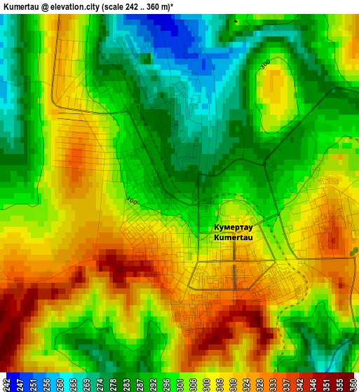
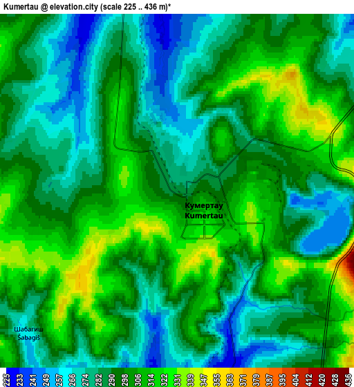
Below is the Elevation map of Kumertau, which displays elevation range with different colors. Scale of the first map is from 242 to 360 m (794 to 1181 ft) with average elevation of 302.6 meters (=993 ft) [note 1]
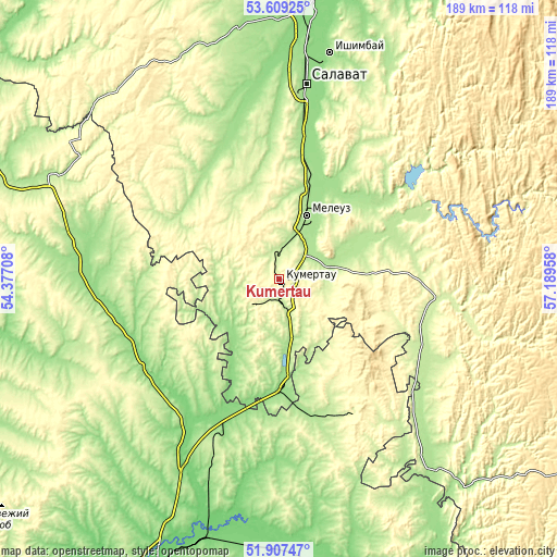
These maps also provides idea of topography and contour of this city, they are displayed at different zoom levels. More info about maps, scale and edge coordinates you can find below images.
| \ | Map #1 | Map #2 | Topo.Map |
| Scale [m] | 242..360 m | 225..436 m | × |
| Scale [ft] | 794..1181 ft | 738..1430 ft | × |
| Average | 302.6 m = 993 ft | 293.7 m = 964 ft | × |
| Width | 5.91 km = 3.7 mi | 11.83 km = 7.4 mi | 189.2 km = 117.6 mi |
| Height | 5.91 km = 3.7 mi | 11.83 km = 7.4 mi | 189.2 km = 117.6 mi |
| ↑Max Latitude | 52.793252° | 52.819817° | 53.60925° |
| Latitude at center | 52.76667° | 52.76667° | 52.76667° |
| ↓Min Latitude | 52.740072° | 52.713458° | 51.90747° |
| ← Min Longitude | 55.739385° | 55.695439° | 54.37708° |
| Longitude center | 55.78333° | 55.78333° | 55.78333° |
| →Max Longitude | 55.827275° | 55.871221° | 57.18958° |
Nearby cities:
Cities around Kumertau sort by population:
• Salavat elevation 159 m
69.1 km,  6°
6°
• Ishimbay 160 m
78.4 km, 12°
• Meleuz 179 m
24.2 km,  24°
24°
• Tyul’gan 308 m
54 km,  151°
151°
• Mrakovo 231 m
56.9 km,  95°
95°
• Sharlyk 165 m
71.4 km,  283°
283°
• Yermolayevo 251 m
5.7 km,  168°
168°
• Yumaguzino 209 m
43.7 km,  69°
69°
• Zirgan 157 m
51.5 km, 10°
• Mayachnyy 308 m
11.3 km,  215°
215°
• Matveyevka 185 m
73.7 km,  158°
158°
• Voskresenskoye 190 m
46.5 km,  31°
31°
Multilingual:
 En español:
Kumertau elevación 285 m.
 En France:
Koumertaou élévation 285 m.
 Auf Deutsch:
Kumertau höhe über dem Meeresspiegel ist 285 m.

Sources and notes:
- [note 1] Map square and city borders are not equal. Map elevation data is calculated only from area inside that square.
- [src 1] Elevation data from geonames database provided with same terms of usage.
- [src 2] The elevation map of Kumertau is generated using elevation data from NASA's 3 arcsec (90m) resolution SRTM data.
- [src 3] Base (background) map © OpenStreetMap contributors tiles are generated by Geofabrik and OpenTopoMap.
Copyright & License:
This Kumertau Elevation Map is licensed under CC BY-SA. You may reuse any part from this page, if you give a proper credit by linking to this URL:
 More info on terms of use page.