Rayevskiy elevation
Rayevskiy (Bashkortostan Republic), Russia elevation is 110 meters and Rayevskiy elevation in feet is 361 ft above sea level [src 1]. Rayevskiy is a populated place (feature code) with elevation that is 89 meters (292 ft) smaller than average city elevation in Russia.
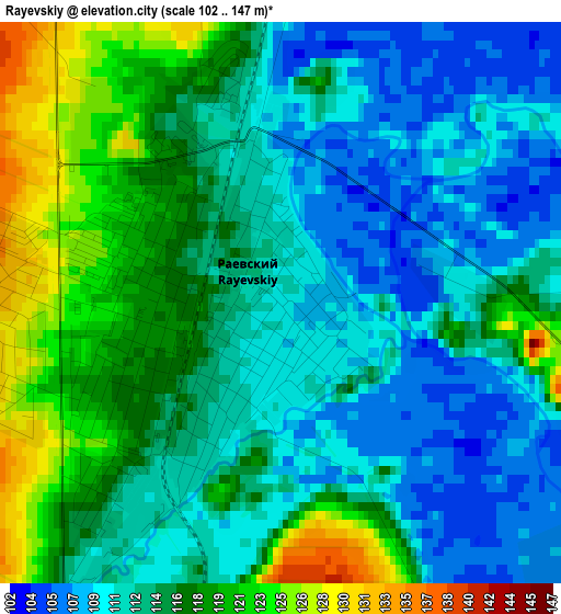
Below is the Elevation map of Rayevskiy, which displays elevation range with different colors. Scale of the first map is from 102 to 147 m (335 to 482 ft) with average elevation of 114.4 meters (=375 ft) [note 1]
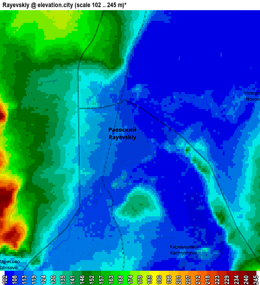
These maps also provides idea of topography and contour of this city, they are displayed at different zoom levels. More info about maps, scale and edge coordinates you can find below images.
| \ | Map #1 | Map #2 | Topo.Map |
| Scale [m] | 102..147 m | 102..245 m | × |
| Scale [ft] | 335..482 ft | 335..804 ft | × |
| Average | 114.4 m = 375 ft | 126.8 m = 416 ft | × |
| Width | 5.74 km = 3.6 mi | 11.47 km = 7.1 mi | 183.5 km = 114 mi |
| Height | 5.74 km = 3.6 mi | 11.47 km = 7.1 mi | 183.5 km = 114 mi |
| ↑Max Latitude | 54.091582° | 54.117347° | 54.88289° |
| Latitude at center | 54.0658° | 54.0658° | 54.0658° |
| ↓Min Latitude | 54.040002° | 54.014189° | 53.23231° |
| ← Min Longitude | 54.902855° | 54.858909° | 53.54055° |
| Longitude center | 54.9468° | 54.9468° | 54.9468° |
| →Max Longitude | 54.990745° | 55.034691° | 56.35305° |
Nearby cities:
Cities around Rayevskiy sort by population:
• Belebey elevation 295 m
54.4 km,  275°
275°
• Davlekanovo 127 m
18.2 km,  18°
18°
• Chishmy 107 m
63.2 km,  26°
26°
• Priyutovo 295 m
68.8 km,  254°
254°
• Tolbazy 213 m
61.3 km,  94°
94°
• Buzdyak 169 m
63 km,  335°
335°
• Kirgiz-Miyaki 221 m
49.2 km,  191°
191°
• Bizhbulyak 252 m
60.7 km,  227°
227°
• Sterlibashevo 254 m
72.8 km,  163°
163°
• Bulgakovo 108 m
77.5 km,  51°
51°
• Aksakovo 330 m
52.1 km,  266°
266°
• Shafranovo 288 m
16.1 km, 226°
Multilingual:
 En español:
Rayevskiy elevación 110 m.
 En France:
Rayevskiy élévation 110 m.
 Auf Deutsch:
Rayevskiy höhe über dem Meeresspiegel ist 110 m.
 На русском:
Раевский, Раевка, Альшеево высота над уровнем моря 110 м
Sources and notes:
- [note 1] Map square and city borders are not equal. Map elevation data is calculated only from area inside that square.
- [src 1] Elevation data from geonames database provided with same terms of usage.
- [src 2] The elevation map of Rayevskiy is generated using elevation data from NASA's 3 arcsec (90m) resolution SRTM data.
- [src 3] Base (background) map © OpenStreetMap contributors tiles are generated by Geofabrik and OpenTopoMap.
Copyright & License:
This Rayevskiy Elevation Map is licensed under CC BY-SA. You may reuse any part from this page, if you give a proper credit by linking to this URL:
 More info on terms of use page.