Tsil’na elevation
Tsil’na (Ulyanovsk), Russia elevation is 102 meters and Tsil’na elevation in feet is 335 ft above sea level [src 1]. Tsil’na is a populated place (feature code) with elevation that is 97 meters (318 ft) smaller than average city elevation in Russia.
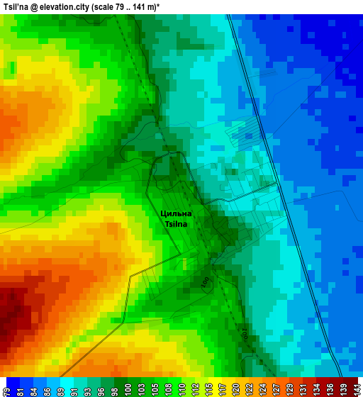
Below is the Elevation map of Tsil’na, which displays elevation range with different colors. Scale of the first map is from 79 to 141 m (259 to 463 ft) with average elevation of 101.6 meters (=333 ft) [note 1]
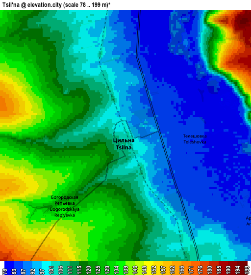
These maps also provides idea of topography and contour of this city, they are displayed at different zoom levels. More info about maps, scale and edge coordinates you can find below images.
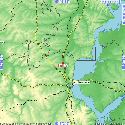
| \ | Map #1 | Map #2 | Topo.Map |
| Scale [m] | 79..141 m | 78..199 m | × |
| Scale [ft] | 259..463 ft | 256..653 ft | × |
| Average | 101.6 m = 333 ft | 111.6 m = 366 ft | × |
| Width | 5.66 km = 3.5 mi | 11.32 km = 7 mi | 181.2 km = 112.6 mi |
| Height | 5.66 km = 3.5 mi | 11.32 km = 7 mi | 181.2 km = 112.6 mi |
| ↑Max Latitude | 54.620782° | 54.646217° | 55.40192° |
| Latitude at center | 54.59533° | 54.59533° | 54.59533° |
| ↓Min Latitude | 54.569862° | 54.544379° | 53.77245° |
| ← Min Longitude | 48.097455° | 48.053509° | 46.73515° |
| Longitude center | 48.1414° | 48.1414° | 48.1414° |
| →Max Longitude | 48.185345° | 48.229291° | 49.54765° |
Nearby cities:
Cities around Tsil’na sort by population:
• Ulyanovsk elevation 176 m
33.7 km,  151°
151°
• Buinsk 93 m
42.9 km,  12°
12°
• Novoul’yanovsk 99 m
52.1 km,  162°
162°
• Cherdakly 68 m
52.5 km,  119°
119°
• Tetyushi 142 m
58.7 km,  49°
49°
• Isheyevka 123 m
20.3 km, 156°
• Staraya Mayna 60 m
50.8 km,  88°
88°
• Yazykovo 167 m
59.2 km,  235°
235°
• Shemursha 160 m
51.4 km,  309°
309°
• Undory 129 m
16.3 km,  84°
84°
• Staroye Drozhzhanoye 178 m
39.7 km,  291°
291°
• Mirnyy 82 m
45.7 km, 123°
Multilingual:
 En español:
Tsil’na elevación 102 m.
 En France:
Tsil’na élévation 102 m.


Sources and notes:
- [note 1] Map square and city borders are not equal. Map elevation data is calculated only from area inside that square.
- [src 1] Elevation data from geonames database provided with same terms of usage.
- [src 2] The elevation map of Tsil’na is generated using elevation data from NASA's 3 arcsec (90m) resolution SRTM data.
- [src 3] Base (background) map © OpenStreetMap contributors tiles are generated by Geofabrik and OpenTopoMap.
Copyright & License:
This Tsil’na Elevation Map is licensed under CC BY-SA. You may reuse any part from this page, if you give a proper credit by linking to this URL:
 More info on terms of use page.