Tetyushi elevation
Tetyushi (Tatarstan Republic), Russia elevation is 142 meters and Tetyushi elevation in feet is 466 ft above sea level [src 1]. Tetyushi is a populated place (feature code) with elevation that is 57 meters (187 ft) smaller than average city elevation in Russia.
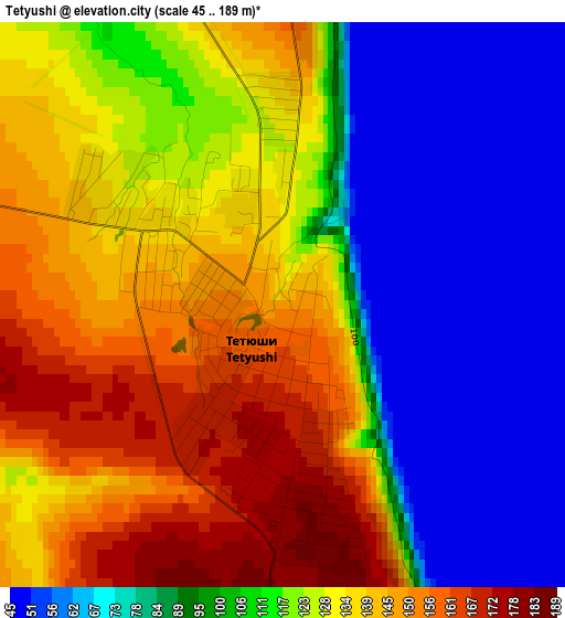
Below is the Elevation map of Tetyushi, which displays elevation range with different colors. Scale of the first map is from 45 to 189 m (148 to 620 ft) with average elevation of 112.5 meters (=369 ft) [note 1]
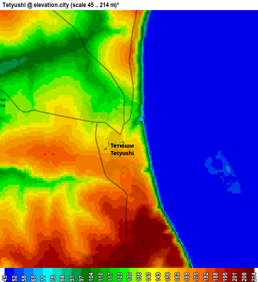
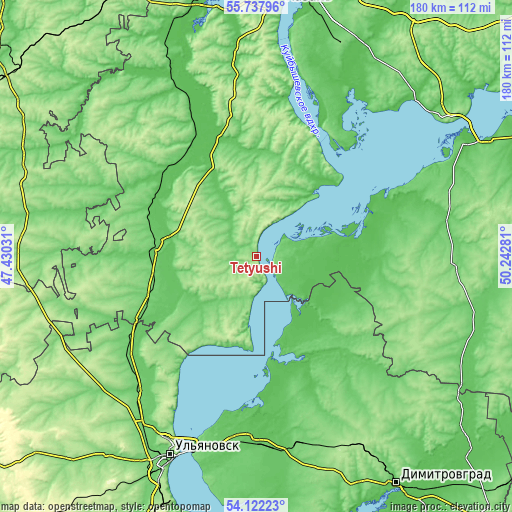
These maps also provides idea of topography and contour of this city, they are displayed at different zoom levels. More info about maps, scale and edge coordinates you can find below images.
| \ | Map #1 | Map #2 | Topo.Map |
| Scale [m] | 45..189 m | 45..214 m | × |
| Scale [ft] | 148..620 ft | 148..702 ft | × |
| Average | 112.5 m = 369 ft | 109.6 m = 360 ft | × |
| Width | 5.61 km = 3.5 mi | 11.23 km = 7 mi | 179.7 km = 111.7 mi |
| Height | 5.61 km = 3.5 mi | 11.23 km = 7 mi | 179.6 km = 111.6 mi |
| ↑Max Latitude | 54.963447° | 54.988668° | 55.73796° |
| Latitude at center | 54.93821° | 54.93821° | 54.93821° |
| ↓Min Latitude | 54.912957° | 54.887689° | 54.12223° |
| ← Min Longitude | 48.792615° | 48.748669° | 47.43031° |
| Longitude center | 48.83656° | 48.83656° | 48.83656° |
| →Max Longitude | 48.880505° | 48.924451° | 50.24281° |
Nearby cities:
Cities around Tetyushi sort by population:
• Buinsk elevation 93 m
35 km,  276°
276°
• Cherdakly 68 m
64.4 km,  179°
179°
• Isheyevka 123 m
67.5 km,  212°
212°
• Bolgar 71 m
14.8 km,  84°
84°
• Laishevo 101 m
68.9 km,  41°
41°
• Staraya Mayna 60 m
37.6 km,  170°
170°
• Bazarnyye Mataki 130 m
70.4 km,  94°
94°
• Apastovo 90 m
36 km,  324°
324°
• Tsil’na 102 m
58.7 km,  229°
229°
• Undory 129 m
46.4 km,  217°
217°
• Mirnyy 82 m
64 km,  186°
186°
• Kuybyshevskiy Zaton 67 m
32.5 km, 40°
Multilingual:
 En español:
Tetyushi elevación 142 m.
 En France:
Tetyushi élévation 142 m.
 Auf Deutsch:
Tetyushi höhe über dem Meeresspiegel ist 142 m.

Sources and notes:
- [note 1] Map square and city borders are not equal. Map elevation data is calculated only from area inside that square.
- [src 1] Elevation data from geonames database provided with same terms of usage.
- [src 2] The elevation map of Tetyushi is generated using elevation data from NASA's 3 arcsec (90m) resolution SRTM data.
- [src 3] Base (background) map © OpenStreetMap contributors tiles are generated by Geofabrik and OpenTopoMap.
Copyright & License:
This Tetyushi Elevation Map is licensed under CC BY-SA. You may reuse any part from this page, if you give a proper credit by linking to this URL:
 More info on terms of use page.