Cherdakly elevation
Cherdakly (Ulyanovsk), Russia elevation is 68 meters and Cherdakly elevation in feet is 223 ft above sea level [src 1]. Cherdakly is a populated place (feature code) with elevation that is 131 meters (430 ft) smaller than average city elevation in Russia.
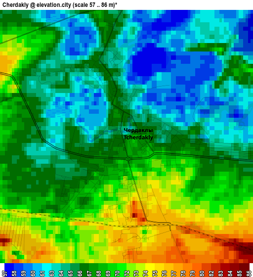
Below is the Elevation map of Cherdakly, which displays elevation range with different colors. Scale of the first map is from 57 to 86 m (187 to 282 ft) with average elevation of 67.3 meters (=221 ft) [note 1]
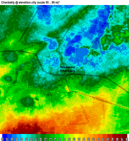
These maps also provides idea of topography and contour of this city, they are displayed at different zoom levels. More info about maps, scale and edge coordinates you can find below images.
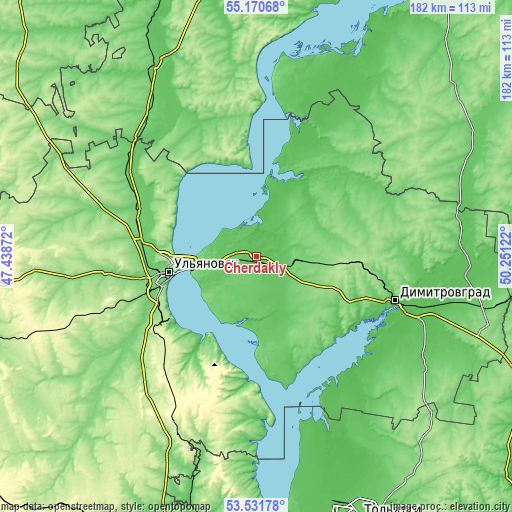
| \ | Map #1 | Map #2 | Topo.Map |
| Scale [m] | 57..86 m | 55..99 m | × |
| Scale [ft] | 187..282 ft | 180..325 ft | × |
| Average | 67.3 m = 221 ft | 71.7 m = 235 ft | × |
| Width | 5.69 km = 3.5 mi | 11.39 km = 7.1 mi | 182.2 km = 113.2 mi |
| Height | 5.69 km = 3.5 mi | 11.39 km = 7.1 mi | 182.2 km = 113.2 mi |
| ↑Max Latitude | 54.384999° | 54.410582° | 55.17068° |
| Latitude at center | 54.3594° | 54.3594° | 54.3594° |
| ↓Min Latitude | 54.333785° | 54.308154° | 53.53178° |
| ← Min Longitude | 48.801025° | 48.757079° | 47.43872° |
| Longitude center | 48.84497° | 48.84497° | 48.84497° |
| →Max Longitude | 48.888915° | 48.932861° | 50.25122° |
Nearby cities:
Cities around Cherdakly sort by population:
• Ulyanovsk elevation 176 m
29.9 km,  263°
263°
• Dimitrovgrad 56 m
52.7 km,  107°
107°
• Novoul’yanovsk 99 m
37.7 km,  231°
231°
• Isheyevka 123 m
38.2 km,  281°
281°
• Sengiley 61 m
44.3 km,  184°
184°
• Staraya Mayna 60 m
27.8 km,  11°
11°
• Mullovka 80 m
40.2 km,  116°
116°
• Tsil’na 102 m
52.5 km,  299°
299°
• Silikatnyy 284 m
53.2 km,  219°
219°
• Undory 129 m
40.3 km,  313°
313°
• Mirnyy 82 m
7.5 km, 275°
• Krasnyy Gulyay 252 m
49.6 km, 222°
Multilingual:
 En español:
Cherdakly elevación 68 m.
 En France:
Cherdakly élévation 68 m.
 Auf Deutsch:
Cherdakly höhe über dem Meeresspiegel ist 68 m.

Sources and notes:
- [note 1] Map square and city borders are not equal. Map elevation data is calculated only from area inside that square.
- [src 1] Elevation data from geonames database provided with same terms of usage.
- [src 2] The elevation map of Cherdakly is generated using elevation data from NASA's 3 arcsec (90m) resolution SRTM data.
- [src 3] Base (background) map © OpenStreetMap contributors tiles are generated by Geofabrik and OpenTopoMap.
Copyright & License:
This Cherdakly Elevation Map is licensed under CC BY-SA. You may reuse any part from this page, if you give a proper credit by linking to this URL:
 More info on terms of use page.