Sengiley elevation
Sengiley (Ulyanovsk), Russia elevation is 61 meters and Sengiley elevation in feet is 200 ft above sea level [src 1]. Sengiley is a populated place (feature code) with elevation that is 138 meters (453 ft) smaller than average city elevation in Russia.
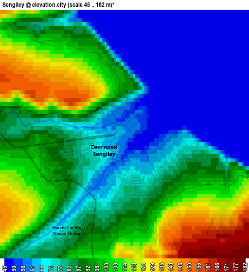
Below is the Elevation map of Sengiley, which displays elevation range with different colors. Scale of the first map is from 45 to 182 m (148 to 597 ft) with average elevation of 87 meters (=285 ft) [note 1]
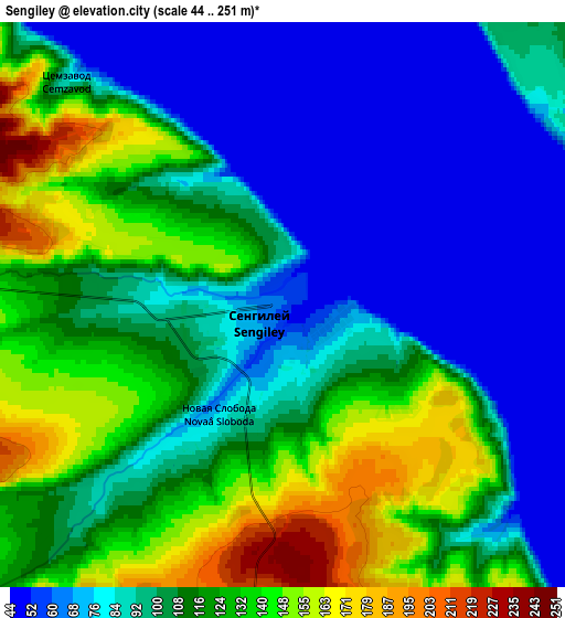
These maps also provides idea of topography and contour of this city, they are displayed at different zoom levels. More info about maps, scale and edge coordinates you can find below images.
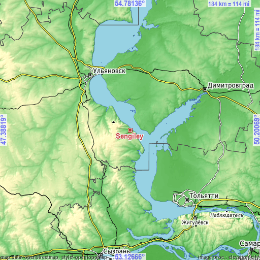
| \ | Map #1 | Map #2 | Topo.Map |
| Scale [m] | 45..182 m | 44..251 m | × |
| Scale [ft] | 148..597 ft | 144..823 ft | × |
| Average | 87 m = 285 ft | 102.6 m = 337 ft | × |
| Width | 5.75 km = 3.6 mi | 11.5 km = 7.1 mi | 184 km = 114.3 mi |
| Height | 5.75 km = 3.6 mi | 11.5 km = 7.1 mi | 184 km = 114.3 mi |
| ↑Max Latitude | 53.988066° | 54.013896° | 54.78136° |
| Latitude at center | 53.96222° | 53.96222° | 53.96222° |
| ↓Min Latitude | 53.936358° | 53.91048° | 53.12666° |
| ← Min Longitude | 48.750495° | 48.706549° | 47.38819° |
| Longitude center | 48.79444° | 48.79444° | 48.79444° |
| →Max Longitude | 48.838385° | 48.882331° | 50.20069° |
Nearby cities:
Cities around Sengiley sort by population:
• Tol’yatti elevation 92 m
60.2 km,  142°
142°
• Ulyanovsk 176 m
48.6 km,  326°
326°
• Dimitrovgrad 56 m
60.6 km,  62°
62°
• Novoul’yanovsk 99 m
33.7 km,  308°
308°
• Cherdakly 68 m
44.3 km,  4°
4°
• Isheyevka 123 m
62.1 km, 326°
• Mullovka 80 m
47.5 km, 56°
• Silikatnyy 284 m
30.7 km,  275°
275°
• Khryashchevka 65 m
25.7 km,  130°
130°
• Mirnyy 82 m
45.1 km,  354°
354°
• Podstepki 66 m
54.5 km,  155°
155°
• Krasnyy Gulyay 252 m
31 km, 283°
Multilingual:
 En español:
Sengiley elevación 61 m.
 En France:
Sengiley élévation 61 m.


Sources and notes:
- [note 1] Map square and city borders are not equal. Map elevation data is calculated only from area inside that square.
- [src 1] Elevation data from geonames database provided with same terms of usage.
- [src 2] The elevation map of Sengiley is generated using elevation data from NASA's 3 arcsec (90m) resolution SRTM data.
- [src 3] Base (background) map © OpenStreetMap contributors tiles are generated by Geofabrik and OpenTopoMap.
Copyright & License:
This Sengiley Elevation Map is licensed under CC BY-SA. You may reuse any part from this page, if you give a proper credit by linking to this URL:
 More info on terms of use page.