Yurla elevation
Yurla (Perm), Russia elevation is 173 meters and Yurla elevation in feet is 568 ft above sea level [src 1]. Yurla is a populated place (feature code) with elevation that is 26 meters (85 ft) smaller than average city elevation in Russia.
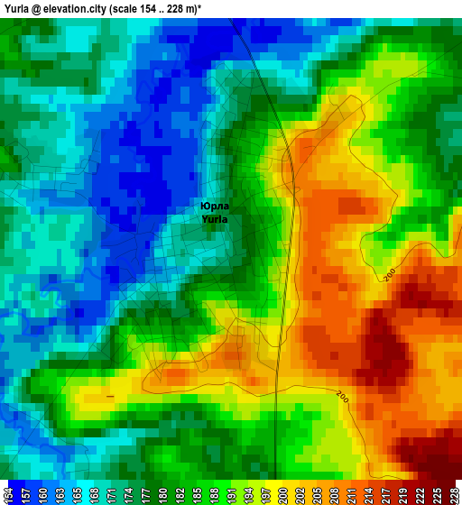
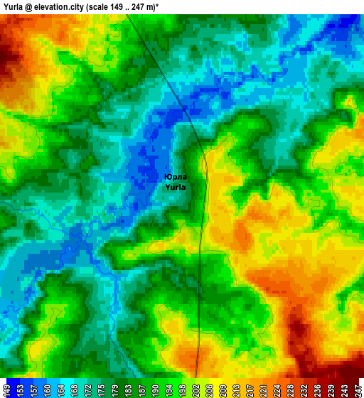
Below is the Elevation map of Yurla, which displays elevation range with different colors. Scale of the first map is from 154 to 228 m (505 to 748 ft) with average elevation of 183.4 meters (=602 ft) [note 1]
These maps also provides idea of topography and contour of this city, they are displayed at different zoom levels. More info about maps, scale and edge coordinates you can find below images.
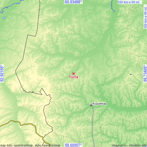
| \ | Map #1 | Map #2 | Topo.Map |
| Scale [m] | 154..228 m | 149..247 m | × |
| Scale [ft] | 505..748 ft | 489..810 ft | × |
| Average | 183.4 m = 602 ft | 188.3 m = 618 ft | × |
| Width | 4.99 km = 3.1 mi | 9.97 km = 6.2 mi | 159.5 km = 99.1 mi |
| Height | 4.99 km = 3.1 mi | 9.97 km = 6.2 mi | 159.5 km = 99.1 mi |
| ↑Max Latitude | 59.347512° | 59.369909° | 60.03498° |
| Latitude at center | 59.3251° | 59.3251° | 59.3251° |
| ↓Min Latitude | 59.302673° | 59.280232° | 58.60007° |
| ← Min Longitude | 54.283855° | 54.239909° | 52.92155° |
| Longitude center | 54.3278° | 54.3278° | 54.3278° |
| →Max Longitude | 54.371745° | 54.415691° | 55.73405° |
Nearby cities:
Cities around Yurla sort by population:
• Kudymkar elevation 166 m
39.4 km,  151°
151°
• Peskovka 197 m
116.3 km,  254°
254°
• Rudnichnyy 183 m
109.8 km,  287°
287°
• Siva 153 m
104.9 km,  178°
178°
• Gayny 130 m
109.2 km,  359°
359°
• Pozhva 149 m
103.6 km,  104°
104°
• Kostino 197 m
76.1 km,  232°
232°
• Kochevo 175 m
30.3 km, 358°
• Maykor 116 m
95.3 km,  111°
111°
• Svetlopolyansk 178 m
111.9 km,  275°
275°
• Kosa 187 m
78.3 km,  28°
28°
• Lesnyye Polyany 218 m
114.6 km, 251°
Multilingual:
 En español:
Yurla elevación 173 m.
 En France:
Yurla élévation 173 m.


Sources and notes:
- [note 1] Map square and city borders are not equal. Map elevation data is calculated only from area inside that square.
- [src 1] Elevation data from geonames database provided with same terms of usage.
- [src 2] The elevation map of Yurla is generated using elevation data from NASA's 3 arcsec (90m) resolution SRTM data.
- [src 3] Base (background) map © OpenStreetMap contributors tiles are generated by Geofabrik and OpenTopoMap.
Copyright & License:
This Yurla Elevation Map is licensed under CC BY-SA. You may reuse any part from this page, if you give a proper credit by linking to this URL:
 More info on terms of use page.