Rudnichnyy elevation
Rudnichnyy (Kirov), Russia elevation is 183 meters and Rudnichnyy elevation in feet is 600 ft above sea level [src 1]. Rudnichnyy is a populated place (feature code) with elevation that is 16 meters (52 ft) smaller than average city elevation in Russia.
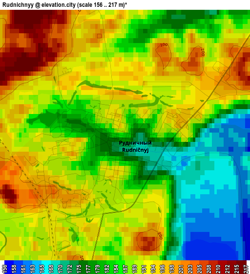
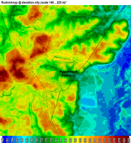
Below is the Elevation map of Rudnichnyy, which displays elevation range with different colors. Scale of the first map is from 156 to 217 m (512 to 712 ft) with average elevation of 187.7 meters (=616 ft) [note 1]
These maps also provides idea of topography and contour of this city, they are displayed at different zoom levels. More info about maps, scale and edge coordinates you can find below images.
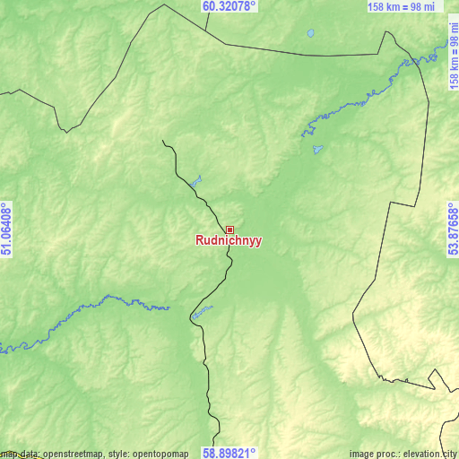
| \ | Map #1 | Map #2 | Topo.Map |
| Scale [m] | 156..217 m | 148..225 m | × |
| Scale [ft] | 512..712 ft | 486..738 ft | × |
| Average | 187.7 m = 616 ft | 183 m = 600 ft | × |
| Width | 4.94 km = 3.1 mi | 9.89 km = 6.1 mi | 158.2 km = 98.3 mi |
| Height | 4.94 km = 3.1 mi | 9.89 km = 6.1 mi | 158.2 km = 98.3 mi |
| ↑Max Latitude | 59.639239° | 59.661444° | 60.32078° |
| Latitude at center | 59.61702° | 59.61702° | 59.61702° |
| ↓Min Latitude | 59.594786° | 59.572537° | 58.89821° |
| ← Min Longitude | 52.426385° | 52.382439° | 51.06408° |
| Longitude center | 52.47033° | 52.47033° | 52.47033° |
| →Max Longitude | 52.514275° | 52.558221° | 53.87658° |
Nearby cities:
Cities around Rudnichnyy sort by population:
• Kirs elevation 159 m
33.5 km,  202°
202°
• Vostochnyy 229 m
93.1 km,  187°
187°
• Lesnoy 174 m
26.5 km,  313°
313°
• Peskovka 197 m
63.9 km, 185°
• Nagorsk 138 m
99.7 km,  250°
250°
• Kostino 197 m
90.8 km,  150°
150°
• Svetlopolyansk 178 m
22.9 km, 195°
• Sozimskiy 160 m
18.7 km,  318°
318°
• Dubrovka 142 m
86 km,  239°
239°
• Lesnyye Polyany 218 m
68.3 km,  182°
182°
• Chërnaya Kholunitsa 190 m
95.4 km,  206°
206°
• Belorechensk 197 m
94.4 km, 186°
Multilingual:
 En español:
Rudnichnyy elevación 183 m.
 En France:
Rudnichnyy élévation 183 m.
 Auf Deutsch:
Rudnichnyy höhe über dem Meeresspiegel ist 183 m.

Sources and notes:
- [note 1] Map square and city borders are not equal. Map elevation data is calculated only from area inside that square.
- [src 1] Elevation data from geonames database provided with same terms of usage.
- [src 2] The elevation map of Rudnichnyy is generated using elevation data from NASA's 3 arcsec (90m) resolution SRTM data.
- [src 3] Base (background) map © OpenStreetMap contributors tiles are generated by Geofabrik and OpenTopoMap.
Copyright & License:
This Rudnichnyy Elevation Map is licensed under CC BY-SA. You may reuse any part from this page, if you give a proper credit by linking to this URL:
 More info on terms of use page.