Pozhva elevation
Pozhva (Perm), Russia elevation is 149 meters and Pozhva elevation in feet is 489 ft above sea level [src 1]. Pozhva is a populated place (feature code) with elevation that is 50 meters (164 ft) smaller than average city elevation in Russia.
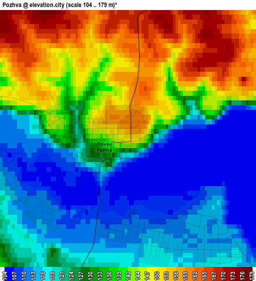
Below is the Elevation map of Pozhva, which displays elevation range with different colors. Scale of the first map is from 104 to 179 m (341 to 587 ft) with average elevation of 131 meters (=430 ft) [note 1]
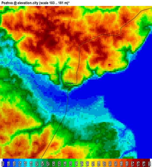
These maps also provides idea of topography and contour of this city, they are displayed at different zoom levels. More info about maps, scale and edge coordinates you can find below images.
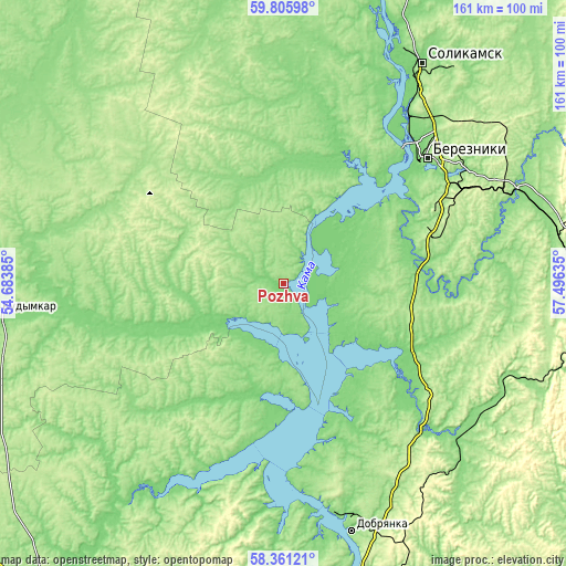
| \ | Map #1 | Map #2 | Topo.Map |
| Scale [m] | 104..179 m | 103..181 m | × |
| Scale [ft] | 341..587 ft | 338..594 ft | × |
| Average | 131 m = 430 ft | 136.7 m = 448 ft | × |
| Width | 5.02 km = 3.1 mi | 10.04 km = 6.2 mi | 160.6 km = 99.8 mi |
| Height | 5.02 km = 3.1 mi | 10.04 km = 6.2 mi | 160.6 km = 99.8 mi |
| ↑Max Latitude | 59.113766° | 59.136317° | 59.80598° |
| Latitude at center | 59.0912° | 59.0912° | 59.0912° |
| ↓Min Latitude | 59.068619° | 59.046023° | 58.36121° |
| ← Min Longitude | 56.046155° | 56.002209° | 54.68385° |
| Longitude center | 56.0901° | 56.0901° | 56.0901° |
| →Max Longitude | 56.134045° | 56.177991° | 57.49635° |
Nearby cities:
Cities around Pozhva sort by population:
• Berezniki elevation 189 m
54.5 km,  49°
49°
• Solikamsk 144 m
71.3 km,  32°
32°
• Dobryanka 132 m
72.1 km,  165°
165°
• Kudymkar 166 m
82.5 km,  263°
263°
• Gubakha 308 m
88.5 km,  108°
108°
• Kizel 293 m
89.2 km,  93°
93°
• Aleksandrovsk 174 m
84.7 km,  84°
84°
• Yayva 137 m
71.8 km,  67°
67°
• Ugleural’skiy 405 m
87.6 km,  100°
100°
• Usol’ye 123 m
50 km,  42°
42°
• Chermoz 132 m
34.7 km, 173°
• Maykor 116 m
15.5 km,  231°
231°
Multilingual:
 En español:
Pozhva elevación 149 m.
 En France:
Pozhva élévation 149 m.


Sources and notes:
- [note 1] Map square and city borders are not equal. Map elevation data is calculated only from area inside that square.
- [src 1] Elevation data from geonames database provided with same terms of usage.
- [src 2] The elevation map of Pozhva is generated using elevation data from NASA's 3 arcsec (90m) resolution SRTM data.
- [src 3] Base (background) map © OpenStreetMap contributors tiles are generated by Geofabrik and OpenTopoMap.
Copyright & License:
This Pozhva Elevation Map is licensed under CC BY-SA. You may reuse any part from this page, if you give a proper credit by linking to this URL:
 More info on terms of use page.