Chermoz elevation
Chermoz (Perm), Russia elevation is 132 meters and Chermoz elevation in feet is 433 ft above sea level [src 1]. Chermoz is a populated place (feature code) with elevation that is 67 meters (220 ft) smaller than average city elevation in Russia.
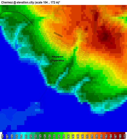
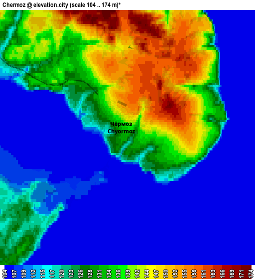
Below is the Elevation map of Chermoz, which displays elevation range with different colors. Scale of the first map is from 104 to 172 m (341 to 564 ft) with average elevation of 127.3 meters (=418 ft) [note 1]
These maps also provides idea of topography and contour of this city, they are displayed at different zoom levels. More info about maps, scale and edge coordinates you can find below images.
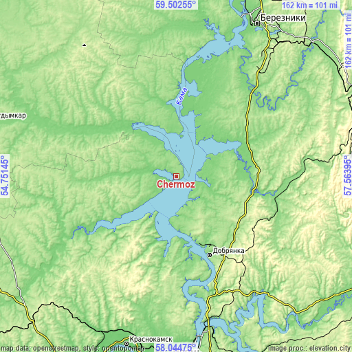
| \ | Map #1 | Map #2 | Topo.Map |
| Scale [m] | 104..172 m | 104..174 m | × |
| Scale [ft] | 341..564 ft | 341..571 ft | × |
| Average | 127.3 m = 418 ft | 121.8 m = 400 ft | × |
| Width | 5.07 km = 3.2 mi | 10.13 km = 6.3 mi | 162.1 km = 100.7 mi |
| Height | 5.07 km = 3.2 mi | 10.13 km = 6.3 mi | 162.1 km = 100.7 mi |
| ↑Max Latitude | 58.80407° | 58.826824° | 59.50255° |
| Latitude at center | 58.7813° | 58.7813° | 58.7813° |
| ↓Min Latitude | 58.758515° | 58.735716° | 58.04475° |
| ← Min Longitude | 56.113755° | 56.069809° | 54.75145° |
| Longitude center | 56.1577° | 56.1577° | 56.1577° |
| →Max Longitude | 56.201645° | 56.245591° | 57.56395° |
Nearby cities:
Cities around Chermoz sort by population:
• Berezniki elevation 189 m
79.4 km,  28°
28°
• Krasnokamsk 108 m
81.5 km,  196°
196°
• Dobryanka 132 m
38.2 km,  157°
157°
• Gubakha 308 m
80.6 km,  85°
85°
• Polazna 159 m
56.4 km, 164°
• Ugleural’skiy 405 m
84.5 km,  77°
77°
• Novyye Lyady 175 m
84.9 km, 161°
• Usol’ye 123 m
77.4 km,  22°
22°
• Overyata 100 m
79.3 km,  192°
192°
• Pozhva 149 m
34.7 km,  353°
353°
• Maykor 116 m
29.6 km,  327°
327°
• Chaykovskaya 130 m
81.1 km,  206°
206°
Multilingual:
 En español:
Chermoz elevación 132 m.
 En France:
Chermoz élévation 132 m.


Sources and notes:
- [note 1] Map square and city borders are not equal. Map elevation data is calculated only from area inside that square.
- [src 1] Elevation data from geonames database provided with same terms of usage.
- [src 2] The elevation map of Chermoz is generated using elevation data from NASA's 3 arcsec (90m) resolution SRTM data.
- [src 3] Base (background) map © OpenStreetMap contributors tiles are generated by Geofabrik and OpenTopoMap.
Copyright & License:
This Chermoz Elevation Map is licensed under CC BY-SA. You may reuse any part from this page, if you give a proper credit by linking to this URL:
 More info on terms of use page.