Siva elevation
Siva (Perm), Russia elevation is 153 meters and Siva elevation in feet is 502 ft above sea level [src 1]. Siva is a populated place (feature code) with elevation that is 46 meters (151 ft) smaller than average city elevation in Russia.
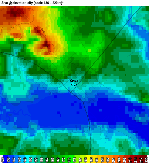
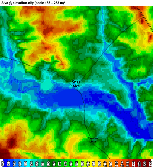
Below is the Elevation map of Siva, which displays elevation range with different colors. Scale of the first map is from 136 to 220 m (446 to 722 ft) with average elevation of 159 meters (=522 ft) [note 1]
These maps also provides idea of topography and contour of this city, they are displayed at different zoom levels. More info about maps, scale and edge coordinates you can find below images.
| \ | Map #1 | Map #2 | Topo.Map |
| Scale [m] | 136..220 m | 135..233 m | × |
| Scale [ft] | 446..722 ft | 443..764 ft | × |
| Average | 159 m = 522 ft | 171 m = 561 ft | × |
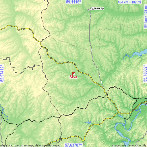
| Width | 5.12 km = 3.2 mi | 10.25 km = 6.4 mi | 164 km = 101.9 mi |
| Height | 5.12 km = 3.2 mi | 10.25 km = 6.4 mi | 163.9 km = 101.8 mi |
| ↑Max Latitude | 58.405071° | 58.428087° | 59.1116° |
| Latitude at center | 58.38204° | 58.38204° | 58.38204° |
| ↓Min Latitude | 58.358994° | 58.335933° | 57.63707° |
| ← Min Longitude | 54.336425° | 54.292479° | 52.97412° |
| Longitude center | 54.38037° | 54.38037° | 54.38037° |
| →Max Longitude | 54.424315° | 54.468261° | 55.78662° |
Nearby cities:
Cities around Siva sort by population:
• Kudymkar elevation 166 m
71.9 km,  12°
12°
• Vereshchagino 237 m
37.4 km,  154°
154°
• Nytva 136 m
74.4 km,  130°
130°
• Ochër 163 m
58.2 km,  159°
159°
• Kez 207 m
66.8 km,  215°
215°
• Karagay 133 m
34.9 km,  111°
111°
• Zyukayka 138 m
27.5 km,  135°
135°
• Ust’-Kachka 96 m
86.6 km,  119°
119°
• Kostino 197 m
87 km,  312°
312°
• Pavlovskiy 118 m
65.9 km, 155°
• Mendeleyevo 214 m
43.1 km, 123°
• Chaykovskaya 130 m
73.2 km, 112°
Multilingual:
 En español:
Siva elevación 153 m.
 En France:
Siva élévation 153 m.


Sources and notes:
- [note 1] Map square and city borders are not equal. Map elevation data is calculated only from area inside that square.
- [src 1] Elevation data from geonames database provided with same terms of usage.
- [src 2] The elevation map of Siva is generated using elevation data from NASA's 3 arcsec (90m) resolution SRTM data.
- [src 3] Base (background) map © OpenStreetMap contributors tiles are generated by Geofabrik and OpenTopoMap.
Copyright & License:
This Siva Elevation Map is licensed under CC BY-SA. You may reuse any part from this page, if you give a proper credit by linking to this URL:
 More info on terms of use page.