Zyukayka elevation
Zyukayka (Perm), Russia elevation is 138 meters and Zyukayka elevation in feet is 453 ft above sea level [src 1]. Zyukayka is a populated place (feature code) with elevation that is 61 meters (200 ft) smaller than average city elevation in Russia.
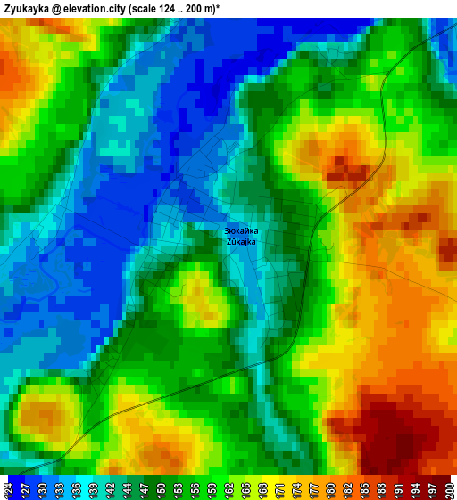
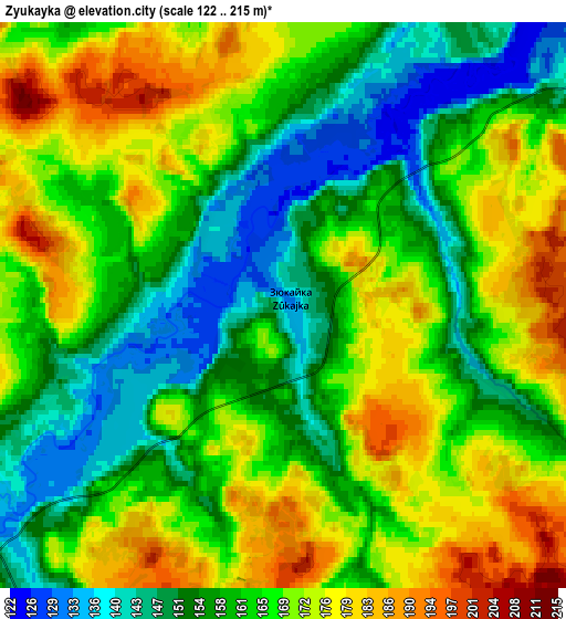
Below is the Elevation map of Zyukayka, which displays elevation range with different colors. Scale of the first map is from 124 to 200 m (407 to 656 ft) with average elevation of 154.4 meters (=507 ft) [note 1]
These maps also provides idea of topography and contour of this city, they are displayed at different zoom levels. More info about maps, scale and edge coordinates you can find below images.
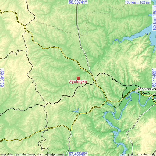
| \ | Map #1 | Map #2 | Topo.Map |
| Scale [m] | 124..200 m | 122..215 m | × |
| Scale [ft] | 407..656 ft | 400..705 ft | × |
| Average | 154.4 m = 507 ft | 163.9 m = 538 ft | × |
| Width | 5.15 km = 3.2 mi | 10.3 km = 6.4 mi | 164.8 km = 102.4 mi |
| Height | 5.15 km = 3.2 mi | 10.3 km = 6.4 mi | 164.8 km = 102.4 mi |
| ↑Max Latitude | 58.227307° | 58.250439° | 58.93741° |
| Latitude at center | 58.20416° | 58.20416° | 58.20416° |
| ↓Min Latitude | 58.180998° | 58.157821° | 57.45545° |
| ← Min Longitude | 54.663895° | 54.619949° | 53.30159° |
| Longitude center | 54.70784° | 54.70784° | 54.70784° |
| →Max Longitude | 54.751785° | 54.795731° | 56.11409° |
Nearby cities:
Cities around Zyukayka sort by population:
• Krasnokamsk elevation 108 m
63 km,  102°
102°
• Vereshchagino 237 m
14.3 km,  192°
192°
• Nytva 136 m
47.1 km,  127°
127°
• Ochër 163 m
34.9 km,  178°
178°
• Kez 207 m
67.8 km,  239°
239°
• Okhansk 117 m
67.1 km,  143°
143°
• Karagay 133 m
15.1 km,  62°
62°
• Siva 153 m
27.5 km,  315°
315°
• Ust’-Kachka 96 m
60.9 km,  111°
111°
• Pavlovskiy 118 m
41 km,  168°
168°
• Mendeleyevo 214 m
17.3 km, 102°
• Chaykovskaya 130 m
49.2 km, 99°
Multilingual:
 En español:
Zyukayka elevación 138 m.
 En France:
Zyukayka élévation 138 m.
 Auf Deutsch:
Zyukayka höhe über dem Meeresspiegel ist 138 m.

Sources and notes:
- [note 1] Map square and city borders are not equal. Map elevation data is calculated only from area inside that square.
- [src 1] Elevation data from geonames database provided with same terms of usage.
- [src 2] The elevation map of Zyukayka is generated using elevation data from NASA's 3 arcsec (90m) resolution SRTM data.
- [src 3] Base (background) map © OpenStreetMap contributors tiles are generated by Geofabrik and OpenTopoMap.
Copyright & License:
This Zyukayka Elevation Map is licensed under CC BY-SA. You may reuse any part from this page, if you give a proper credit by linking to this URL:
 More info on terms of use page.