Nytva elevation
Nytva (Perm), Russia elevation is 136 meters and Nytva elevation in feet is 446 ft above sea level [src 1]. Nytva is a seat of a second-order administrative division (feature code) with elevation that is 63 meters (207 ft) smaller than average city elevation in Russia.
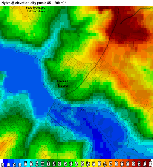
Below is the Elevation map of Nytva, which displays elevation range with different colors. Scale of the first map is from 85 to 209 m (279 to 686 ft) with average elevation of 134.9 meters (=443 ft) [note 1]
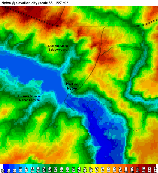
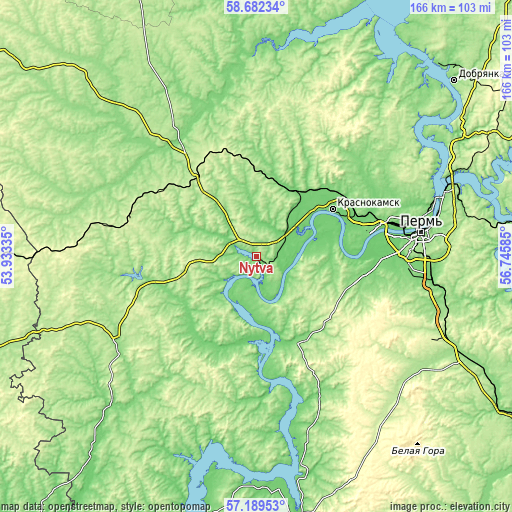
These maps also provides idea of topography and contour of this city, they are displayed at different zoom levels. More info about maps, scale and edge coordinates you can find below images.
| \ | Map #1 | Map #2 | Topo.Map |
| Scale [m] | 85..209 m | 85..227 m | × |
| Scale [ft] | 279..686 ft | 279..745 ft | × |
| Average | 134.9 m = 443 ft | 148.2 m = 486 ft | × |
| Width | 5.19 km = 3.2 mi | 10.37 km = 6.4 mi | 166 km = 103.1 mi |
| Height | 5.19 km = 3.2 mi | 10.37 km = 6.4 mi | 166 km = 103.1 mi |
| ↑Max Latitude | 57.967016° | 57.990318° | 58.68234° |
| Latitude at center | 57.9437° | 57.9437° | 57.9437° |
| ↓Min Latitude | 57.920368° | 57.897022° | 57.18953° |
| ← Min Longitude | 55.295655° | 55.251709° | 53.93335° |
| Longitude center | 55.3396° | 55.3396° | 55.3396° |
| →Max Longitude | 55.383545° | 55.427491° | 56.74585° |
Nearby cities:
Cities around Nytva sort by population:
• Krasnokamsk elevation 108 m
28.8 km,  58°
58°
• Vereshchagino 237 m
43 km,  290°
290°
• Ochër 163 m
37.1 km,  260°
260°
• Okhansk 117 m
25 km,  173°
173°
• Yugo-Kamskiy 121 m
30.6 km,  151°
151°
• Overyata 100 m
34.8 km, 63°
• Kultayevo 120 m
35.7 km,  98°
98°
• Ust’-Kachka 96 m
20.7 km,  71°
71°
• Pavlovskiy 118 m
31.4 km,  248°
248°
• Mendeleyevo 214 m
32.2 km,  321°
321°
• Chaykovskaya 130 m
23.6 km,  29°
29°
• Sokol 118 m
41.8 km,  94°
94°
Multilingual:
 En español:
Nytva elevación 136 m.
 En France:
Nytva élévation 136 m.


Sources and notes:
- [note 1] Map square and city borders are not equal. Map elevation data is calculated only from area inside that square.
- [src 1] Elevation data from geonames database provided with same terms of usage.
- [src 2] The elevation map of Nytva is generated using elevation data from NASA's 3 arcsec (90m) resolution SRTM data.
- [src 3] Base (background) map © OpenStreetMap contributors tiles are generated by Geofabrik and OpenTopoMap.
Copyright & License:
This Nytva Elevation Map is licensed under CC BY-SA. You may reuse any part from this page, if you give a proper credit by linking to this URL:
 More info on terms of use page.