Kultayevo elevation
Kultayevo (Perm), Russia elevation is 120 meters and Kultayevo elevation in feet is 394 ft above sea level [src 1]. Kultayevo is a populated place (feature code) with elevation that is 79 meters (259 ft) smaller than average city elevation in Russia.
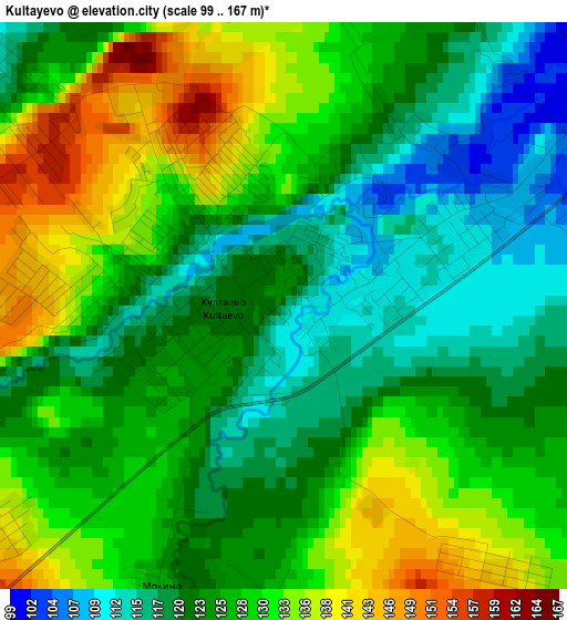
Below is the Elevation map of Kultayevo, which displays elevation range with different colors. Scale of the first map is from 99 to 167 m (325 to 548 ft) with average elevation of 126.1 meters (=414 ft) [note 1]
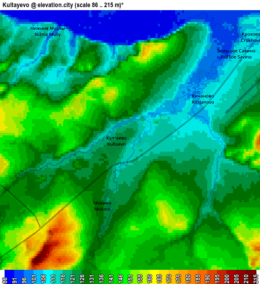
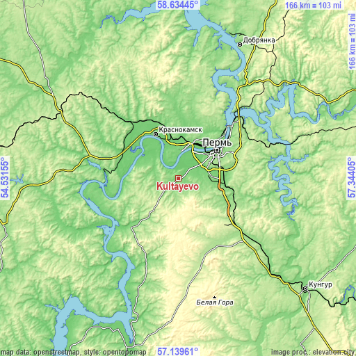
These maps also provides idea of topography and contour of this city, they are displayed at different zoom levels. More info about maps, scale and edge coordinates you can find below images.
| \ | Map #1 | Map #2 | Topo.Map |
| Scale [m] | 99..167 m | 86..215 m | × |
| Scale [ft] | 325..548 ft | 282..705 ft | × |
| Average | 126.1 m = 414 ft | 128 m = 420 ft | × |
| Width | 5.19 km = 3.2 mi | 10.39 km = 6.5 mi | 166.2 km = 103.3 mi |
| Height | 5.19 km = 3.2 mi | 10.39 km = 6.5 mi | 166.2 km = 103.3 mi |
| ↑Max Latitude | 57.918148° | 57.941481° | 58.63445° |
| Latitude at center | 57.8948° | 57.8948° | 57.8948° |
| ↓Min Latitude | 57.871437° | 57.848058° | 57.13961° |
| ← Min Longitude | 55.893855° | 55.849909° | 54.53155° |
| Longitude center | 55.9378° | 55.9378° | 55.9378° |
| →Max Longitude | 55.981745° | 56.025691° | 57.34405° |
Nearby cities:
Cities around Kultayevo sort by population:
• Perm elevation 149 m
22.5 km,  55°
55°
• Krasnokamsk 108 m
23.2 km,  332°
332°
• Zvëzdnyy 220 m
28.7 km,  128°
128°
• Kondratovo 96 m
13.8 km,  46°
46°
• Overyata 100 m
21.5 km,  348°
348°
• Gamovo 148 m
10.5 km,  108°
108°
• Ust’-Kachka 96 m
19.8 km,  307°
307°
• Lobanovo 132 m
21.9 km,  100°
100°
• Ferma 109 m
21.8 km,  88°
88°
• Froly 118 m
20 km,  81°
81°
• Yug 225 m
23 km,  142°
142°
• Sokol 118 m
6.7 km,  70°
70°
Multilingual:
 En español:
Kultayevo elevación 120 m.
 En France:
Kultayevo élévation 120 m.
 Auf Deutsch:
Kultayevo höhe über dem Meeresspiegel ist 120 m.

Sources and notes:
- [note 1] Map square and city borders are not equal. Map elevation data is calculated only from area inside that square.
- [src 1] Elevation data from geonames database provided with same terms of usage.
- [src 2] The elevation map of Kultayevo is generated using elevation data from NASA's 3 arcsec (90m) resolution SRTM data.
- [src 3] Base (background) map © OpenStreetMap contributors tiles are generated by Geofabrik and OpenTopoMap.
Copyright & License:
This Kultayevo Elevation Map is licensed under CC BY-SA. You may reuse any part from this page, if you give a proper credit by linking to this URL:
 More info on terms of use page.