Chegdomyn elevation
Chegdomyn (Khabarovsk), Russia elevation is 426 meters and Chegdomyn elevation in feet is 1398 ft above sea level [src 1]. Chegdomyn is a populated place (feature code) with elevation that is 227 meters (745 ft) bigger than average city elevation in Russia.
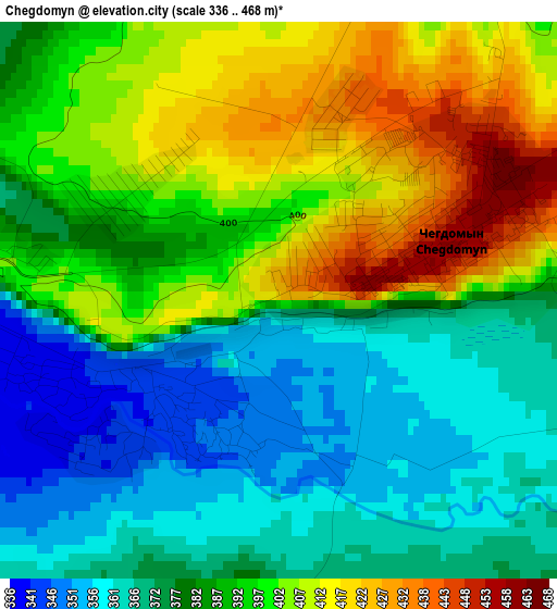
Below is the Elevation map of Chegdomyn, which displays elevation range with different colors. Scale of the first map is from 336 to 468 m (1102 to 1535 ft) with average elevation of 387.4 meters (=1271 ft) [note 1]
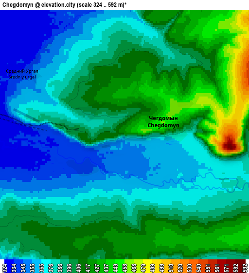
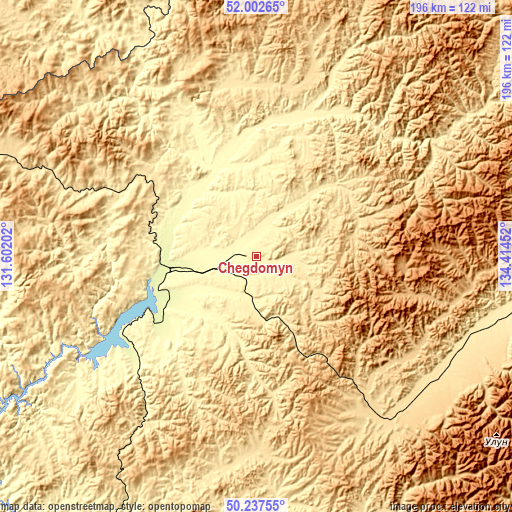
These maps also provides idea of topography and contour of this city, they are displayed at different zoom levels. More info about maps, scale and edge coordinates you can find below images.
| \ | Map #1 | Map #2 | Topo.Map |
| Scale [m] | 336..468 m | 324..592 m | × |
| Scale [ft] | 1102..1535 ft | 1063..1942 ft | × |
| Average | 387.4 m = 1271 ft | 392.4 m = 1287 ft | × |
| Width | 6.13 km = 3.8 mi | 12.27 km = 7.6 mi | 196.3 km = 122 mi |
| Height | 6.13 km = 3.8 mi | 12.27 km = 7.6 mi | 196.2 km = 121.9 mi |
| ↑Max Latitude | 51.156101° | 51.183655° | 52.00265° |
| Latitude at center | 51.12853° | 51.12853° | 51.12853° |
| ↓Min Latitude | 51.100943° | 51.073339° | 50.23755° |
| ← Min Longitude | 132.964325° | 132.920379° | 131.60202° |
| Longitude center | 133.00827° | 133.00827° | 133.00827° |
| →Max Longitude | 133.052215° | 133.096161° | 134.41452° |
Nearby cities:
Cities around Chegdomyn sort by population:
• Novyy Urgal elevation 317 m
29.2 km,  257°
257°
• Talakan 269 m
215.6 km,  243°
243°
• Berëzovyy 163 m
193.9 km,  71°
71°
• Bira 166 m
239.6 km,  189°
189°
• Gorin 71 m
254.9 km,  88°
88°
• Birakan 231 m
254.6 km,  201°
201°
• Tyrma 291 m
134.6 km,  206°
206°
• Kul’dur 374 m
235.1 km, 204°
• Gornyy 471 m
244.4 km,  99°
99°
• Londoko 207 m
245.6 km, 197°
• Ekimchan 497 m
215.9 km,  358°
358°
• Tokur 551 m
223.3 km, 357°
Multilingual:
 En español:
Chegdomyn elevación 426 m.
 En France:
Chegdomyn élévation 426 m.
 Auf Deutsch:
Chegdomyn höhe über dem Meeresspiegel ist 426 m.

Sources and notes:
- [note 1] Map square and city borders are not equal. Map elevation data is calculated only from area inside that square.
- [src 1] Elevation data from geonames database provided with same terms of usage.
- [src 2] The elevation map of Chegdomyn is generated using elevation data from NASA's 3 arcsec (90m) resolution SRTM data.
- [src 3] Base (background) map © OpenStreetMap contributors tiles are generated by Geofabrik and OpenTopoMap.
Copyright & License:
This Chegdomyn Elevation Map is licensed under CC BY-SA. You may reuse any part from this page, if you give a proper credit by linking to this URL:
 More info on terms of use page.