Gorin elevation
Gorin (Khabarovsk), Russia elevation is 71 meters and Gorin elevation in feet is 233 ft above sea level [src 1]. Gorin is a populated place (feature code) with elevation that is 128 meters (420 ft) smaller than average city elevation in Russia.
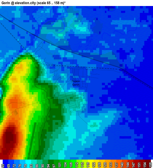
Below is the Elevation map of Gorin, which displays elevation range with different colors. Scale of the first map is from 65 to 158 m (213 to 518 ft) with average elevation of 82.2 meters (=270 ft) [note 1]
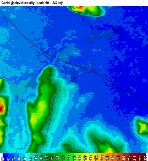
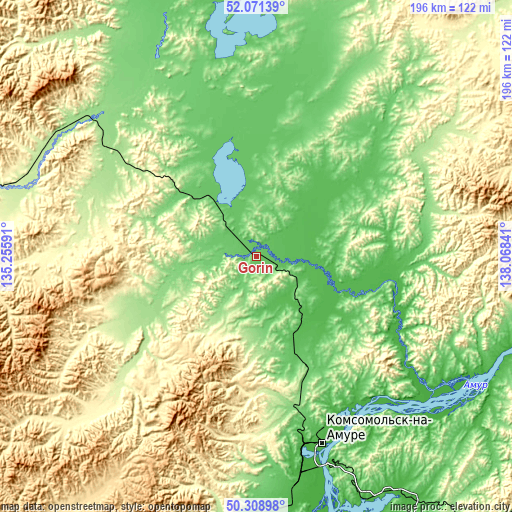
These maps also provides idea of topography and contour of this city, they are displayed at different zoom levels. More info about maps, scale and edge coordinates you can find below images.
| \ | Map #1 | Map #2 | Topo.Map |
| Scale [m] | 65..158 m | 60..232 m | × |
| Scale [ft] | 213..518 ft | 197..761 ft | × |
| Average | 82.2 m = 270 ft | 82.2 m = 270 ft | × |
| Width | 6.12 km = 3.8 mi | 12.25 km = 7.6 mi | 196 km = 121.8 mi |
| Height | 6.12 km = 3.8 mi | 12.25 km = 7.6 mi | 195.9 km = 121.7 mi |
| ↑Max Latitude | 51.226139° | 51.253651° | 52.07139° |
| Latitude at center | 51.19861° | 51.19861° | 51.19861° |
| ↓Min Latitude | 51.171065° | 51.143503° | 50.30898° |
| ← Min Longitude | 136.618215° | 136.574269° | 135.25591° |
| Longitude center | 136.66216° | 136.66216° | 136.66216° |
| →Max Longitude | 136.706105° | 136.750051° | 138.06841° |
Nearby cities:
Cities around Gorin sort by population:
• Komsomolsk-on-Amur elevation 36 m
76.1 km,  161°
161°
• Amursk 45 m
108 km,  171°
171°
• Chegdomyn 426 m
254.9 km,  268°
268°
• Solnechnyy 294 m
52.8 km,  181°
181°
• Solnechnyy 33 m
73.2 km, 159°
• Berëzovyy 163 m
86.6 km,  307°
307°
• Khurba 45 m
89.4 km, 170°
• Selikhino 53 m
109.6 km,  147°
147°
• Vysokogornyy 451 m
212.2 km,  125°
125°
• Litovko 71 m
242.4 km,  205°
205°
• Imeni Poliny Osipenko 69 m
136.6 km,  354°
354°
• Gornyy 471 m
50.6 km,  197°
197°
Multilingual:
 En español:
Gorin elevación 71 m.
 En France:
Gorin élévation 71 m.


Sources and notes:
- [note 1] Map square and city borders are not equal. Map elevation data is calculated only from area inside that square.
- [src 1] Elevation data from geonames database provided with same terms of usage.
- [src 2] The elevation map of Gorin is generated using elevation data from NASA's 3 arcsec (90m) resolution SRTM data.
- [src 3] Base (background) map © OpenStreetMap contributors tiles are generated by Geofabrik and OpenTopoMap.
Copyright & License:
This Gorin Elevation Map is licensed under CC BY-SA. You may reuse any part from this page, if you give a proper credit by linking to this URL:
 More info on terms of use page.