Talakan elevation
Talakan (Amur Oblast), Russia elevation is 269 meters and Talakan elevation in feet is 883 ft above sea level [src 1]. Talakan is a populated place (feature code) with elevation that is 70 meters (230 ft) bigger than average city elevation in Russia.
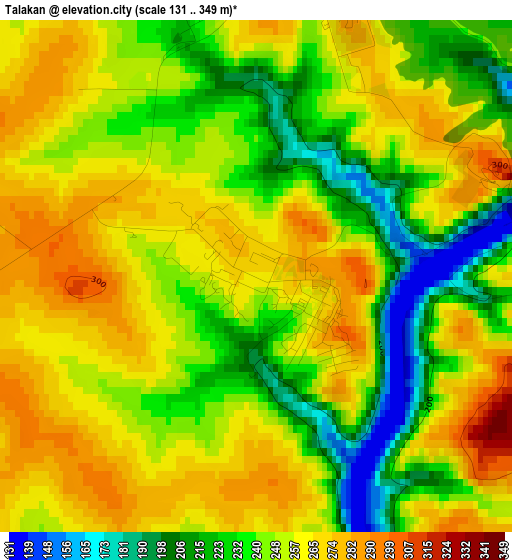
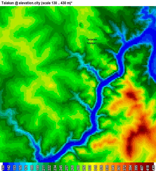
Below is the Elevation map of Talakan, which displays elevation range with different colors. Scale of the first map is from 131 to 349 m (430 to 1145 ft) with average elevation of 249.4 meters (=818 ft) [note 1]
These maps also provides idea of topography and contour of this city, they are displayed at different zoom levels. More info about maps, scale and edge coordinates you can find below images.
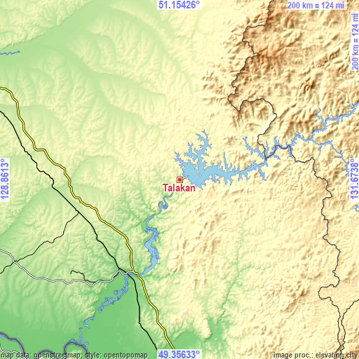
| \ | Map #1 | Map #2 | Topo.Map |
| Scale [m] | 131..349 m | 130..430 m | × |
| Scale [ft] | 430..1145 ft | 427..1411 ft | × |
| Average | 249.4 m = 818 ft | 255.8 m = 839 ft | × |
| Width | 6.25 km = 3.9 mi | 12.49 km = 7.8 mi | 199.9 km = 124.2 mi |
| Height | 6.25 km = 3.9 mi | 12.49 km = 7.8 mi | 199.9 km = 124.2 mi |
| ↑Max Latitude | 50.291864° | 50.319931° | 51.15426° |
| Latitude at center | 50.26378° | 50.26378° | 50.26378° |
| ↓Min Latitude | 50.235679° | 50.207562° | 49.35633° |
| ← Min Longitude | 130.223605° | 130.179659° | 128.8613° |
| Longitude center | 130.26755° | 130.26755° | 130.26755° |
| →Max Longitude | 130.311495° | 130.355441° | 131.6738° |
Nearby cities:
Cities around Talakan sort by population:
• Raychikhinsk elevation 190 m
80.8 km,  229°
229°
• Zavitinsk 237 m
61.2 km,  253°
253°
• Arkhara 161 m
94.2 km,  187°
187°
• Yekaterinoslavka 236 m
83.1 km,  278°
278°
• Novobureyskiy 120 m
59 km,  208°
208°
• Poyarkovo 115 m
135.5 km,  238°
238°
• Bureya 133 m
59.8 km, 212°
• Romny 232 m
85.7 km,  306°
306°
• Novoraychikhinsk 167 m
72 km,  222°
222°
• Tyrma 291 m
136.2 km,  100°
100°
• Khingansk 445 m
142.7 km,  152°
152°
• Shirokiy 176 m
77.5 km, 223°
Multilingual:
 En español:
Talakan elevación 269 m.
 En France:
Talakan élévation 269 m.


Sources and notes:
- [note 1] Map square and city borders are not equal. Map elevation data is calculated only from area inside that square.
- [src 1] Elevation data from geonames database provided with same terms of usage.
- [src 2] The elevation map of Talakan is generated using elevation data from NASA's 3 arcsec (90m) resolution SRTM data.
- [src 3] Base (background) map © OpenStreetMap contributors tiles are generated by Geofabrik and OpenTopoMap.
Copyright & License:
This Talakan Elevation Map is licensed under CC BY-SA. You may reuse any part from this page, if you give a proper credit by linking to this URL:
 More info on terms of use page.