Kosjerić elevation
Kosjerić (Central Serbia, Zlatibor), Serbia elevation is 423 meters and Kosjerić elevation in feet is 1388 ft above sea level [src 1]. Kosjerić is a seat of a third-order administrative division (feature code) with elevation that is 256 meters (840 ft) bigger than average city elevation in Serbia.
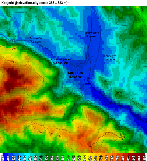
Below is the Elevation map of Kosjerić, which displays elevation range with different colors. Scale of the first map is from 385 to 883 m (1263 to 2897 ft) with average elevation of 560.2 meters (=1838 ft) [note 1]
These maps also provides idea of topography and contour of this city, they are displayed at different zoom levels. More info about maps, scale and edge coordinates you can find below images.
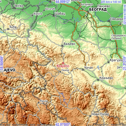
| \ | Map #1 | Topo.Map |
| Scale [m] | 385..883 m | × |
| Scale [ft] | 1263..2897 ft | × |
| Average | 560.2 m = 1838 ft | × |
| Width | 7.03 km = 4.4 mi | 225 km = 139.8 mi |
| Height | 7.03 km = 4.4 mi | 225 km = 139.8 mi |
| ↑Max Latitude | 44.027715° | 44.99912° |
| Latitude at center | 43.99611° | 43.99611° |
| ↓Min Latitude | 43.964488° | 42.97585° |
| ← Min Longitude | 19.862995° | 18.50069° |
| Longitude center | 19.90694° | 19.90694° |
| →Max Longitude | 19.950885° | 21.31319° |
Nearby cities:
Cities around Kosjerić sort by population:
• Čačak elevation 241 m
37.3 km,  108°
108°
• Užice 438 m
16 km,  196°
196°
• Valjevo 180 m
31 km,  358°
358°
• Bajina Bašta 242 m
27.3 km,  264°
264°
• Arilje 334 m
31 km,  150°
150°
• Čajetina 857 m
31.5 km,  209°
209°
• Ljig 154 m
37.1 km,  45°
45°
• Zlatibor 980 m
34 km, 209°
• Gornja Bukovica 362 m
38.9 km,  348°
348°
• Mionica 179 m
31.7 km,  26°
26°
• Lučani 310 m
23.8 km,  129°
129°
• Požega 321 m
19.4 km, 147°
Multilingual:
 En español:
Kosjerić elevación 423 m.
 En France:
Kosjerić élévation 423 m.
 Auf Deutsch:
Kosjerić höhe über dem Meeresspiegel ist 423 m.

Sources and notes:
- [note 1] Map square and city borders are not equal. Map elevation data is calculated only from area inside that square.
- [src 1] Elevation data from geonames database provided with same terms of usage.
- [src 2] The elevation map of Kosjerić is generated using elevation data from NASA's 3 arcsec (90m) resolution SRTM data.
- [src 3] Base (background) map © OpenStreetMap contributors tiles are generated by Geofabrik and OpenTopoMap.
Copyright & License:
This Kosjerić Elevation Map is licensed under CC BY-SA. You may reuse any part from this page, if you give a proper credit by linking to this URL:
 More info on terms of use page.