Valjevo elevation
Valjevo (Central Serbia, Kolubara), Serbia elevation is 180 meters and Valjevo elevation in feet is 591 ft above sea level [src 1]. Valjevo is a seat of a second-order administrative division (feature code) with elevation that is 13 meters (43 ft) bigger than average city elevation in Serbia.
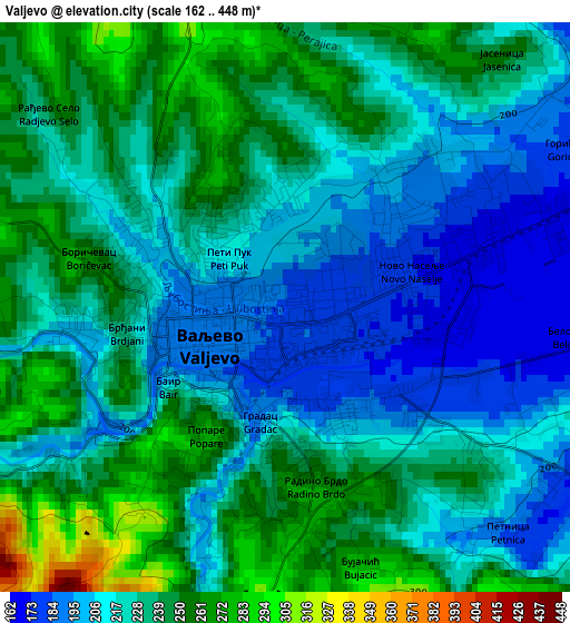
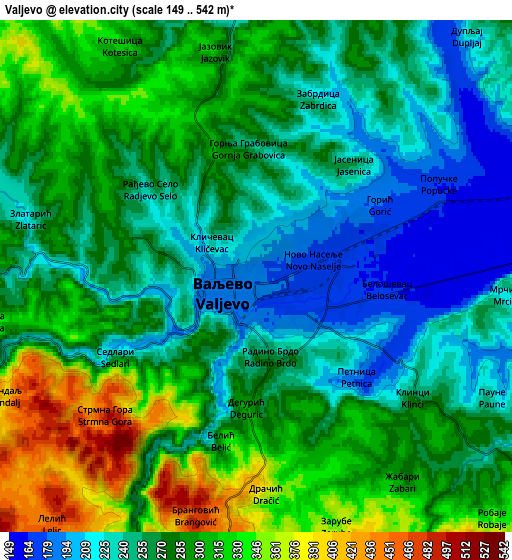
Below is the Elevation map of Valjevo, which displays elevation range with different colors. Scale of the first map is from 162 to 448 m (531 to 1470 ft) with average elevation of 227 meters (=745 ft) [note 1]
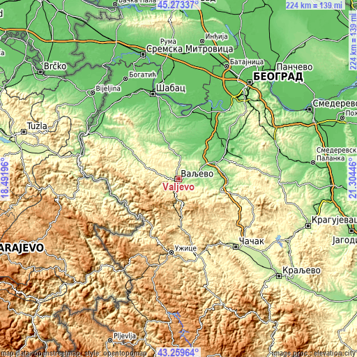
These maps also provides idea of topography and contour of this city, they are displayed at different zoom levels. More info about maps, scale and edge coordinates you can find below images.
| \ | Map #1 | Map #2 | Topo.Map |
| Scale [m] | 162..448 m | 149..542 m | × |
| Scale [ft] | 531..1470 ft | 489..1778 ft | × |
| Average | 227 m = 745 ft | 275.2 m = 903 ft | × |
| Width | 7 km = 4.3 mi | 13.99 km = 8.7 mi | 223.9 km = 139.1 mi |
| Height | 7 km = 4.3 mi | 13.99 km = 8.7 mi | 223.9 km = 139.1 mi |
| ↑Max Latitude | 44.306586° | 44.338026° | 45.27337° |
| Latitude at center | 44.27513° | 44.27513° | 44.27513° |
| ↓Min Latitude | 44.243657° | 44.212167° | 43.25964° |
| ← Min Longitude | 19.854265° | 19.810319° | 18.49196° |
| Longitude center | 19.89821° | 19.89821° | 19.89821° |
| →Max Longitude | 19.942155° | 19.986101° | 21.30446° |
Nearby cities:
Cities around Valjevo sort by population:
• Lazarevac elevation 117 m
31 km,  66°
66°
• Osečina 202 m
26 km,  294°
294°
• Ljig 154 m
27.5 km,  100°
100°
• Draginje 234 m
30.6 km,  339°
339°
• Brdarica 179 m
32.6 km, 342°
• Gornja Bukovica 362 m
9.9 km,  316°
316°
• Kamenica 346 m
15.8 km,  298°
298°
• Kosjerić 423 m
31 km,  178°
178°
• Ub 98 m
24.5 km,  34°
34°
• Lajkovac 111 m
23.7 km,  63°
63°
• Koceljeva 129 m
23.1 km, 342°
• Mionica 179 m
14.8 km, 100°
Multilingual:
 En español:
Valjevo elevación 180 m.
 En France:
Valjevo élévation 180 m.


Sources and notes:
- [note 1] Map square and city borders are not equal. Map elevation data is calculated only from area inside that square.
- [src 1] Elevation data from geonames database provided with same terms of usage.
- [src 2] The elevation map of Valjevo is generated using elevation data from NASA's 3 arcsec (90m) resolution SRTM data.
- [src 3] Base (background) map © OpenStreetMap contributors tiles are generated by Geofabrik and OpenTopoMap.
Copyright & License:
This Valjevo Elevation Map is licensed under CC BY-SA. You may reuse any part from this page, if you give a proper credit by linking to this URL:
 More info on terms of use page.