Lazarevac elevation
Lazarevac (Central Serbia, Belgrade), Serbia elevation is 117 meters and Lazarevac elevation in feet is 384 ft above sea level [src 1]. Lazarevac is a seat of a third-order administrative division (feature code) with elevation that is 50 meters (164 ft) smaller than average city elevation in Serbia.
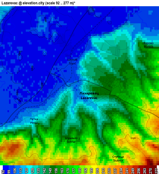
Below is the Elevation map of Lazarevac, which displays elevation range with different colors. Scale of the first map is from 92 to 277 m (302 to 909 ft) with average elevation of 138 meters (=453 ft) [note 1]
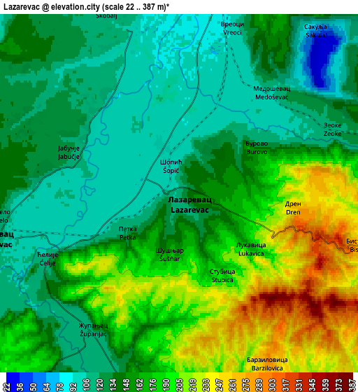
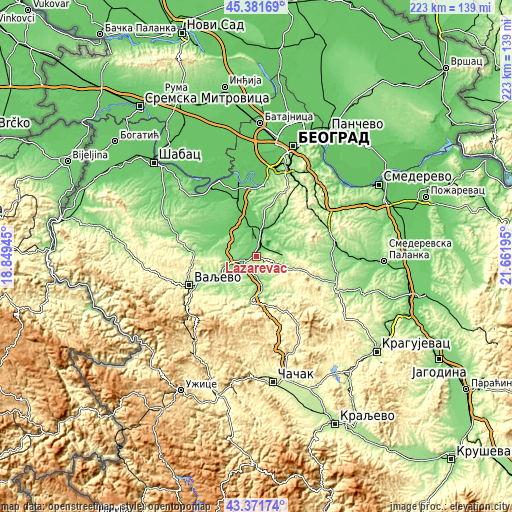
These maps also provides idea of topography and contour of this city, they are displayed at different zoom levels. More info about maps, scale and edge coordinates you can find below images.
| \ | Map #1 | Map #2 | Topo.Map |
| Scale [m] | 92..277 m | 22..387 m | × |
| Scale [ft] | 302..909 ft | 72..1270 ft | × |
| Average | 138 m = 453 ft | 157.3 m = 516 ft | × |
| Width | 6.98 km = 4.3 mi | 13.97 km = 8.7 mi | 223.5 km = 138.9 mi |
| Height | 6.98 km = 4.3 mi | 13.97 km = 8.7 mi | 223.5 km = 138.9 mi |
| ↑Max Latitude | 44.416737° | 44.448117° | 45.38169° |
| Latitude at center | 44.38534° | 44.38534° | 44.38534° |
| ↓Min Latitude | 44.353926° | 44.322495° | 43.37174° |
| ← Min Longitude | 20.211755° | 20.167809° | 18.84945° |
| Longitude center | 20.2557° | 20.2557° | 20.2557° |
| →Max Longitude | 20.299645° | 20.343591° | 21.66195° |
Nearby cities:
Cities around Lazarevac sort by population:
• Aranđelovac elevation 251 m
25.7 km,  109°
109°
• Grabovac 112 m
27.5 km,  330°
330°
• Vranić 209 m
24.8 km,  13°
13°
• Ljig 154 m
17.3 km,  184°
184°
• Stubline 108 m
23.1 km,  335°
335°
• Stepojevac 132 m
14.5 km, 12°
• Mala Moštanica 113 m
28.4 km, 8°
• Sopot 188 m
29.3 km,  59°
59°
• Barajevo 142 m
25 km,  30°
30°
• Mionica 179 m
20.3 km,  223°
223°
• Ub 98 m
16.4 km,  298°
298°
• Lajkovac 111 m
7.4 km,  256°
256°
Multilingual:
 En español:
Lazarevac elevación 117 m.
 En France:
Lazarevac élévation 117 m.
 Auf Deutsch:
Lazarevac höhe über dem Meeresspiegel ist 117 m.

Sources and notes:
- [note 1] Map square and city borders are not equal. Map elevation data is calculated only from area inside that square.
- [src 1] Elevation data from geonames database provided with same terms of usage.
- [src 2] The elevation map of Lazarevac is generated using elevation data from NASA's 3 arcsec (90m) resolution SRTM data.
- [src 3] Base (background) map © OpenStreetMap contributors tiles are generated by Geofabrik and OpenTopoMap.
Copyright & License:
This Lazarevac Elevation Map is licensed under CC BY-SA. You may reuse any part from this page, if you give a proper credit by linking to this URL:
 More info on terms of use page.