Bajina Bašta elevation
Bajina Bašta (Central Serbia, Zlatibor), Serbia elevation is 242 meters and Bajina Bašta elevation in feet is 794 ft above sea level [src 1]. Bajina Bašta is a seat of a third-order administrative division (feature code) with elevation that is 75 meters (246 ft) bigger than average city elevation in Serbia.
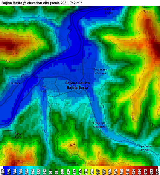
Below is the Elevation map of Bajina Bašta, which displays elevation range with different colors. Scale of the first map is from 205 to 712 m (673 to 2336 ft) with average elevation of 369.1 meters (=1211 ft) [note 1]
These maps also provides idea of topography and contour of this city, they are displayed at different zoom levels. More info about maps, scale and edge coordinates you can find below images.
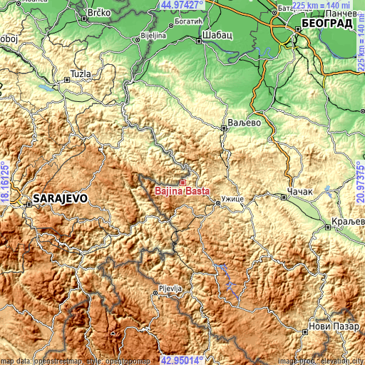
| \ | Map #1 | Map #2 | Topo.Map |
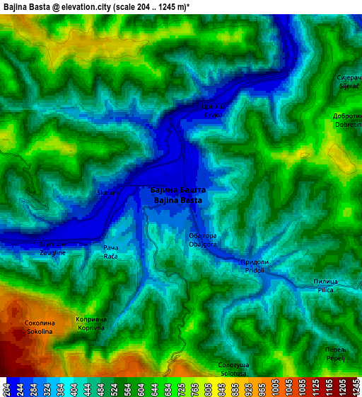
| Scale [m] | 205..712 m | 204..1245 m | × |
| Scale [ft] | 673..2336 ft | 669..4085 ft | × |
| Average | 369.1 m = 1211 ft | 527.5 m = 1731 ft | × |
| Width | 7.03 km = 4.4 mi | 14.07 km = 8.7 mi | 225.1 km = 139.9 mi |
| Height | 7.03 km = 4.4 mi | 14.07 km = 8.7 mi | 225.1 km = 139.9 mi |
| ↑Max Latitude | 44.002449° | 44.034051° | 44.97427° |
| Latitude at center | 43.97083° | 43.97083° | 43.97083° |
| ↓Min Latitude | 43.939194° | 43.907542° | 42.95014° |
| ← Min Longitude | 19.523555° | 19.479609° | 18.16125° |
| Longitude center | 19.5675° | 19.5675° | 19.5675° |
| →Max Longitude | 19.611445° | 19.655391° | 20.97375° |
Nearby cities:
Cities around Bajina Bašta sort by population:
• Užice elevation 438 m
25.8 km,  118°
118°
• Valjevo 180 m
42.9 km,  37°
37°
• Osečina 202 m
44.8 km,  3°
3°
• Čajetina 857 m
27.2 km,  154°
154°
• Ljubovija 178 m
28.7 km,  327°
327°
• Zlatibor 980 m
28.9 km,  158°
158°
• Gornja Bukovica 362 m
45.5 km,  25°
25°
• Kamenica 346 m
43.2 km,  16°
16°
• Ðurići 981 m
20.4 km,  217°
217°
• Priboj 398 m
43.2 km,  184°
184°
• Požega 321 m
39.9 km,  109°
109°
• Kosjerić 423 m
27.3 km,  84°
84°
Multilingual:
 En español:
Bajina Bašta elevación 242 m.
 En France:
Bajina Bašta élévation 242 m.
 Auf Deutsch:
Bajina Bašta höhe über dem Meeresspiegel ist 242 m.

Sources and notes:
- [note 1] Map square and city borders are not equal. Map elevation data is calculated only from area inside that square.
- [src 1] Elevation data from geonames database provided with same terms of usage.
- [src 2] The elevation map of Bajina Bašta is generated using elevation data from NASA's 3 arcsec (90m) resolution SRTM data.
- [src 3] Base (background) map © OpenStreetMap contributors tiles are generated by Geofabrik and OpenTopoMap.
Copyright & License:
This Bajina Bašta Elevation Map is licensed under CC BY-SA. You may reuse any part from this page, if you give a proper credit by linking to this URL:
 More info on terms of use page.