Arilje elevation
Arilje (Central Serbia, Zlatibor), Serbia elevation is 334 meters and Arilje elevation in feet is 1096 ft above sea level [src 1]. Arilje is a seat of a third-order administrative division (feature code) with elevation that is 167 meters (548 ft) bigger than average city elevation in Serbia.
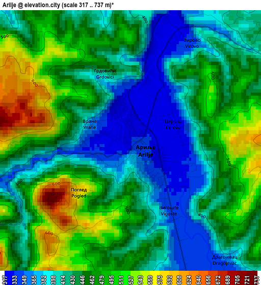
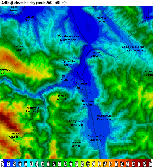
Below is the Elevation map of Arilje, which displays elevation range with different colors. Scale of the first map is from 317 to 737 m (1040 to 2418 ft) with average elevation of 446.6 meters (=1465 ft) [note 1]
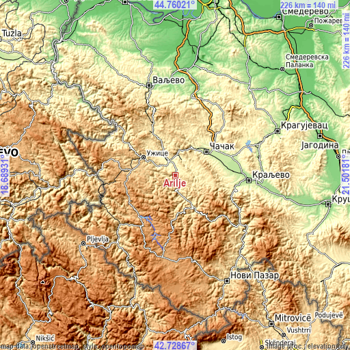
These maps also provides idea of topography and contour of this city, they are displayed at different zoom levels. More info about maps, scale and edge coordinates you can find below images.
| \ | Map #1 | Map #2 | Topo.Map |
| Scale [m] | 317..737 m | 305..951 m | × |
| Scale [ft] | 1040..2418 ft | 1001..3120 ft | × |
| Average | 446.6 m = 1465 ft | 482.4 m = 1583 ft | × |
| Width | 7.06 km = 4.4 mi | 14.12 km = 8.8 mi | 225.9 km = 140.4 mi |
| Height | 7.06 km = 4.4 mi | 14.12 km = 8.8 mi | 225.9 km = 140.4 mi |
| ↑Max Latitude | 43.784794° | 43.816512° | 44.76021° |
| Latitude at center | 43.75306° | 43.75306° | 43.75306° |
| ↓Min Latitude | 43.721309° | 43.689541° | 42.72867° |
| ← Min Longitude | 20.051615° | 20.007669° | 18.68931° |
| Longitude center | 20.09556° | 20.09556° | 20.09556° |
| →Max Longitude | 20.139505° | 20.183451° | 21.50181° |
Nearby cities:
Cities around Arilje sort by population:
• Čačak elevation 241 m
25.5 km,  52°
52°
• Kraljevo 207 m
47.8 km,  93°
93°
• Užice 438 m
23 km,  300°
300°
• Gornji Milanovac 326 m
42.2 km,  44°
44°
• Čajetina 857 m
30.8 km,  269°
269°
• Zlatibor 980 m
31.9 km, 265°
• Prislonica 377 m
35.1 km, 50°
• Nova Varoš 987 m
39.8 km,  215°
215°
• Kosjerić 423 m
31 km,  330°
330°
• Ivanjica 466 m
22.1 km,  150°
150°
• Lučani 310 m
12.5 km,  15°
15°
• Požega 321 m
11.7 km,  335°
335°
Multilingual:
 En español:
Arilje elevación 334 m.
 En France:
Arilje élévation 334 m.


Sources and notes:
- [note 1] Map square and city borders are not equal. Map elevation data is calculated only from area inside that square.
- [src 1] Elevation data from geonames database provided with same terms of usage.
- [src 2] The elevation map of Arilje is generated using elevation data from NASA's 3 arcsec (90m) resolution SRTM data.
- [src 3] Base (background) map © OpenStreetMap contributors tiles are generated by Geofabrik and OpenTopoMap.
Copyright & License:
This Arilje Elevation Map is licensed under CC BY-SA. You may reuse any part from this page, if you give a proper credit by linking to this URL:
 More info on terms of use page.