Prislonica elevation
Prislonica (Central Serbia, Morava), Serbia elevation is 377 meters and Prislonica elevation in feet is 1237 ft above sea level [src 1]. Prislonica is a populated place (feature code) with elevation that is 210 meters (689 ft) bigger than average city elevation in Serbia.
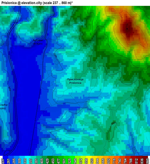
Below is the Elevation map of Prislonica, which displays elevation range with different colors. Scale of the first map is from 237 to 860 m (778 to 2822 ft) with average elevation of 366.2 meters (=1201 ft) [note 1]
These maps also provides idea of topography and contour of this city, they are displayed at different zoom levels. More info about maps, scale and edge coordinates you can find below images.
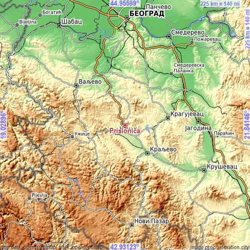
| \ | Map #1 | Topo.Map |
| Scale [m] | 237..860 m | × |
| Scale [ft] | 778..2822 ft | × |
| Average | 366.2 m = 1201 ft | × |
| Width | 7.04 km = 4.4 mi | 225.1 km = 139.9 mi |
| Height | 7.04 km = 4.4 mi | 225.1 km = 139.9 mi |
| ↑Max Latitude | 43.983859° | 44.95599° |
| Latitude at center | 43.95223° | 43.95223° |
| ↓Min Latitude | 43.920585° | 42.93123° |
| ← Min Longitude | 20.391265° | 19.02896° |
| Longitude center | 20.43521° | 20.43521° |
| →Max Longitude | 20.479155° | 21.84146° |
Nearby cities:
Cities around Prislonica sort by population:
• Kragujevac elevation 182 m
39.2 km,  79°
79°
• Čačak 241 m
9.6 km,  225°
225°
• Kraljevo 207 m
32.4 km,  140°
140°
• Aranđelovac 251 m
40.7 km,  14°
14°
• Gornji Milanovac 326 m
8.5 km, 14°
• Arilje 334 m
35.1 km, 230°
• Ljig 154 m
34.7 km,  333°
333°
• Kosjerić 423 m
42.6 km,  276°
276°
• Topola 276 m
38.9 km,  30°
30°
• Požega 321 m
34 km,  250°
250°
• Lučani 310 m
25.9 km, 246°
• Knić 320 m
22.9 km,  97°
97°
Multilingual:
 En español:
Prislonica elevación 377 m.
 En France:
Prislonica élévation 377 m.
 Auf Deutsch:
Prislonica höhe über dem Meeresspiegel ist 377 m.

Sources and notes:
- [note 1] Map square and city borders are not equal. Map elevation data is calculated only from area inside that square.
- [src 1] Elevation data from geonames database provided with same terms of usage.
- [src 2] The elevation map of Prislonica is generated using elevation data from NASA's 3 arcsec (90m) resolution SRTM data.
- [src 3] Base (background) map © OpenStreetMap contributors tiles are generated by Geofabrik and OpenTopoMap.
Copyright & License:
This Prislonica Elevation Map is licensed under CC BY-SA. You may reuse any part from this page, if you give a proper credit by linking to this URL:
 More info on terms of use page.