Agăş elevation
Agăş (Bacău, Comuna Agăş), Romania elevation is 563 meters and Agăş elevation in feet is 1847 ft above sea level [src 1]. Agăş is a seat of a second-order administrative division (feature code) with elevation that is 311 meters (1020 ft) bigger than average city elevation in Romania.
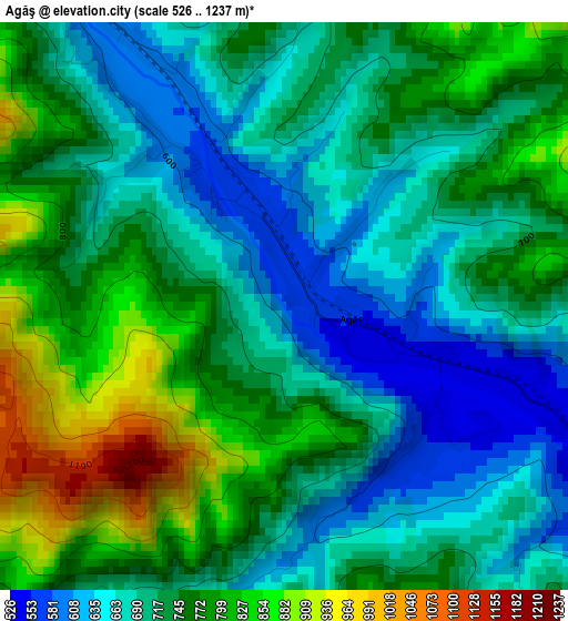
Below is the Elevation map of Agăş, which displays elevation range with different colors. Scale of the first map is from 526 to 1237 m (1726 to 4058 ft) with average elevation of 732.6 meters (=2404 ft) [note 1]
These maps also provides idea of topography and contour of this city, they are displayed at different zoom levels. More info about maps, scale and edge coordinates you can find below images.
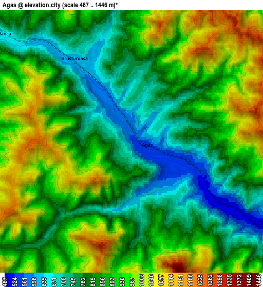
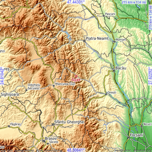
| \ | Map #1 | Map #2 | Topo.Map |
| Scale [m] | 526..1237 m | 487..1446 m | × |
| Scale [ft] | 1726..4058 ft | 1598..4744 ft | × |
| Average | 732.6 m = 2404 ft | 870.5 m = 2856 ft | × |
| Width | 6.73 km = 4.2 mi | 13.46 km = 8.4 mi | 215.3 km = 133.8 mi |
| Height | 6.73 km = 4.2 mi | 13.46 km = 8.4 mi | 215.3 km = 133.8 mi |
| ↑Max Latitude | 46.513581° | 46.543815° | 47.44301° |
| Latitude at center | 46.48333° | 46.48333° | 46.48333° |
| ↓Min Latitude | 46.453062° | 46.422778° | 45.50641° |
| ← Min Longitude | 26.172725° | 26.128779° | 24.81042° |
| Longitude center | 26.21667° | 26.21667° | 26.21667° |
| →Max Longitude | 26.260615° | 26.304561° | 27.62292° |
Nearby cities:
Cities around Agăş sort by population:
• Comăneşti elevation 385 m
18.2 km,  112°
112°
• Asău 409 m
15.1 km, 111°
• Ghimeş-Făget 804 m
16 km,  314°
314°
• Zemeş 853 m
18.9 km,  53°
53°
• Palanca 684 m
9.5 km, 305°
• Brusturoasa 763 m
3.9 km,  341°
341°
• Ciugheș 679 m
8.6 km,  300°
300°
• Făget 758 m
17.1 km, 313°
• Apa Asău 509 m
12.4 km,  87°
87°
• Cotumba 640 m
2.5 km, 308°
• Straja 464 m
12.2 km, 113°
• Ghimeș 710 m
13.6 km, 313°
Multilingual:
 En español:
Agăş elevación 563 m.
 En France:
Agăş élévation 563 m.


Sources and notes:
- [note 1] Map square and city borders are not equal. Map elevation data is calculated only from area inside that square.
- [src 1] Elevation data from geonames database provided with same terms of usage.
- [src 2] The elevation map of Agăş is generated using elevation data from NASA's 3 arcsec (90m) resolution SRTM data.
- [src 3] Base (background) map © OpenStreetMap contributors tiles are generated by Geofabrik and OpenTopoMap.
Copyright & License:
This Agăş Elevation Map is licensed under CC BY-SA. You may reuse any part from this page, if you give a proper credit by linking to this URL:
 More info on terms of use page.