Ghimeş-Făget elevation
Ghimeş-Făget (Bacău, Comuna Ghimeş-Făget), Romania elevation is 804 meters and Ghimeş-Făget elevation in feet is 2638 ft above sea level [src 1]. Ghimeş-Făget is a seat of a second-order administrative division (feature code) with elevation that is 552 meters (1811 ft) bigger than average city elevation in Romania.
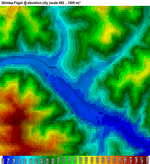
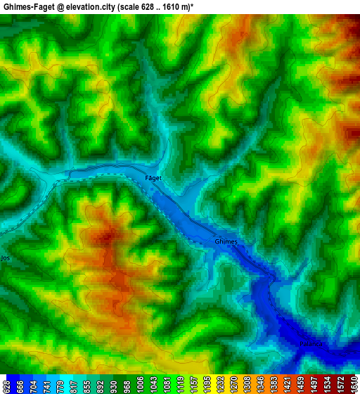
Below is the Elevation map of Ghimeş-Făget, which displays elevation range with different colors. Scale of the first map is from 682 to 1509 m (2238 to 4951 ft) with average elevation of 968.2 meters (=3177 ft) [note 1]
These maps also provides idea of topography and contour of this city, they are displayed at different zoom levels. More info about maps, scale and edge coordinates you can find below images.
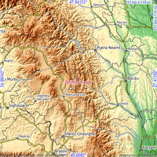
| \ | Map #1 | Map #2 | Topo.Map |
| Scale [m] | 682..1509 m | 628..1610 m | × |
| Scale [ft] | 2238..4951 ft | 2060..5282 ft | × |
| Average | 968.2 m = 3177 ft | 1030.3 m = 3380 ft | × |
| Width | 6.72 km = 4.2 mi | 13.43 km = 8.3 mi | 214.9 km = 133.5 mi |
| Height | 6.72 km = 4.2 mi | 13.43 km = 8.3 mi | 214.9 km = 133.5 mi |
| ↑Max Latitude | 46.613525° | 46.643703° | 47.54123° |
| Latitude at center | 46.58333° | 46.58333° | 46.58333° |
| ↓Min Latitude | 46.553118° | 46.522889° | 45.6082° |
| ← Min Longitude | 26.022725° | 25.978779° | 24.66042° |
| Longitude center | 26.06667° | 26.06667° | 26.06667° |
| →Max Longitude | 26.110615° | 26.154561° | 27.47292° |
Nearby cities:
Cities around Ghimeş-Făget sort by population:
• Bălan elevation 890 m
21.1 km,  290°
290°
• Agăş 563 m
16 km,  134°
134°
• Lunca de Jos 899 m
6.6 km,  253°
253°
• Palanca 684 m
6.7 km,  145°
145°
• Brusturoasa 763 m
12.6 km, 126°
• Lunca de Sus 973 m
9.5 km,  233°
233°
• Valea Rece 864 m
9.3 km,  296°
296°
• Ciugheș 679 m
7.9 km, 149°
• Făget 758 m
1.2 km, 301°
• Cotumba 640 m
13.5 km,  135°
135°
• Ghimeș 710 m
2.4 km, 134°
• Bolovăniș 849 m
3.8 km,  343°
343°
Multilingual:
 En español:
Ghimeş-Făget elevación 804 m.
 En France:
Ghimeş-Făget élévation 804 m.
 Auf Deutsch:
Ghimeş-Făget höhe über dem Meeresspiegel ist 804 m.

Sources and notes:
- [note 1] Map square and city borders are not equal. Map elevation data is calculated only from area inside that square.
- [src 1] Elevation data from geonames database provided with same terms of usage.
- [src 2] The elevation map of Ghimeş-Făget is generated using elevation data from NASA's 3 arcsec (90m) resolution SRTM data.
- [src 3] Base (background) map © OpenStreetMap contributors tiles are generated by Geofabrik and OpenTopoMap.
Copyright & License:
This Ghimeş-Făget Elevation Map is licensed under CC BY-SA. You may reuse any part from this page, if you give a proper credit by linking to this URL:
 More info on terms of use page.