Lunca de Sus elevation
Lunca de Sus (Harghita, Comuna Lunca de Sus), Romania elevation is 973 meters and Lunca de Sus elevation in feet is 3192 ft above sea level [src 1]. Lunca de Sus is a seat of a second-order administrative division (feature code) with elevation that is 721 meters (2365 ft) bigger than average city elevation in Romania.
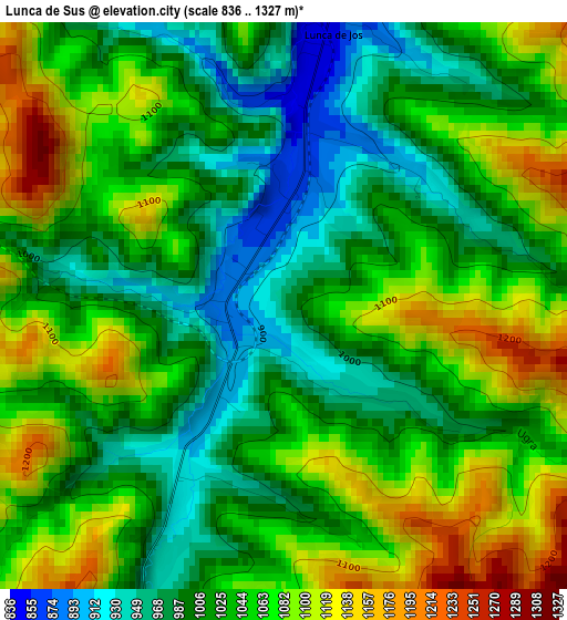
Below is the Elevation map of Lunca de Sus, which displays elevation range with different colors. Scale of the first map is from 836 to 1327 m (2743 to 4354 ft) with average elevation of 1038.6 meters (=3407 ft) [note 1]
These maps also provides idea of topography and contour of this city, they are displayed at different zoom levels. More info about maps, scale and edge coordinates you can find below images.
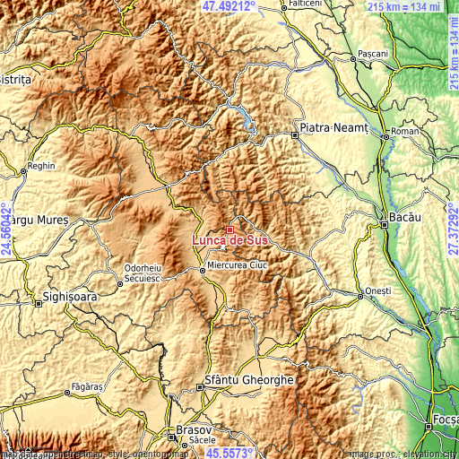
| \ | Map #1 | Topo.Map |
| Scale [m] | 836..1327 m | × |
| Scale [ft] | 2743..4354 ft | × |
| Average | 1038.6 m = 3407 ft | × |
| Width | 6.72 km = 4.2 mi | 215.1 km = 133.7 mi |
| Height | 6.72 km = 4.2 mi | 215.1 km = 133.7 mi |
| ↑Max Latitude | 46.563553° | 47.49212° |
| Latitude at center | 46.53333° | 46.53333° |
| ↓Min Latitude | 46.50309° | 45.5573° |
| ← Min Longitude | 25.922725° | 24.56042° |
| Longitude center | 25.96667° | 25.96667° |
| →Max Longitude | 26.010615° | 27.37292° |
Nearby cities:
Cities around Lunca de Sus sort by population:
• Ghimeş-Făget elevation 804 m
9.5 km,  53°
53°
• Lunca de Jos 899 m
3.9 km,  18°
18°
• Palanca 684 m
11.5 km,  90°
90°
• Frumoasa 785 m
12.9 km,  223°
223°
• Tomești 734 m
14.6 km,  280°
280°
• Mihăileni 733 m
13.7 km,  237°
237°
• Valea Rece 864 m
9.7 km,  356°
356°
• Ciugheș 679 m
11.8 km,  96°
96°
• Făget 758 m
9.1 km, 47°
• Ghimeș 710 m
10.1 km,  67°
67°
• Nicolești 788 m
14 km, 221°
• Bolovăniș 849 m
11.3 km,  35°
35°
Multilingual:
 En español:
Lunca de Sus elevación 973 m.
 En France:
Lunca de Sus élévation 973 m.
 Auf Deutsch:
Lunca de Sus höhe über dem Meeresspiegel ist 973 m.

Sources and notes:
- [note 1] Map square and city borders are not equal. Map elevation data is calculated only from area inside that square.
- [src 1] Elevation data from geonames database provided with same terms of usage.
- [src 2] The elevation map of Lunca de Sus is generated using elevation data from NASA's 3 arcsec (90m) resolution SRTM data.
- [src 3] Base (background) map © OpenStreetMap contributors tiles are generated by Geofabrik and OpenTopoMap.
Copyright & License:
This Lunca de Sus Elevation Map is licensed under CC BY-SA. You may reuse any part from this page, if you give a proper credit by linking to this URL:
 More info on terms of use page.