Zemeş elevation
Zemeş (Bacău, Comuna Zemeş), Romania elevation is 853 meters and Zemeş elevation in feet is 2799 ft above sea level [src 1]. Zemeş is a seat of a second-order administrative division (feature code) with elevation that is 601 meters (1972 ft) bigger than average city elevation in Romania.
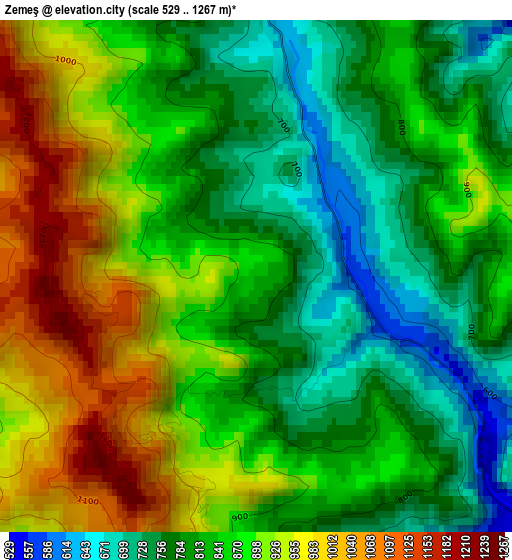
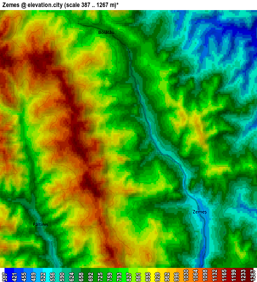
Below is the Elevation map of Zemeş, which displays elevation range with different colors. Scale of the first map is from 529 to 1267 m (1736 to 4157 ft) with average elevation of 854 meters (=2802 ft) [note 1]
These maps also provides idea of topography and contour of this city, they are displayed at different zoom levels. More info about maps, scale and edge coordinates you can find below images.
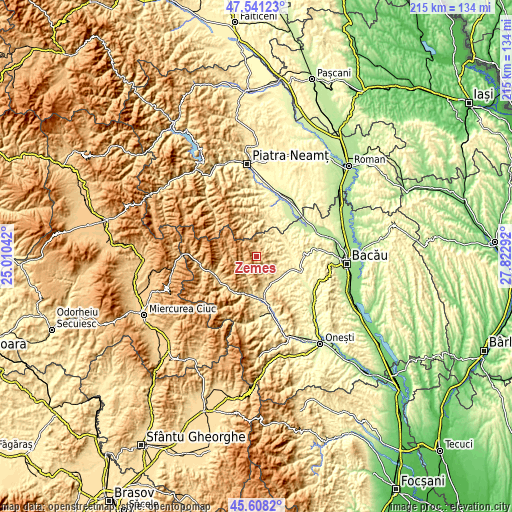
| \ | Map #1 | Map #2 | Topo.Map |
| Scale [m] | 529..1267 m | 387..1267 m | × |
| Scale [ft] | 1736..4157 ft | 1270..4157 ft | × |
| Average | 854 m = 2802 ft | 797.4 m = 2616 ft | × |
| Width | 6.72 km = 4.2 mi | 13.43 km = 8.3 mi | 214.9 km = 133.5 mi |
| Height | 6.72 km = 4.2 mi | 13.43 km = 8.3 mi | 214.9 km = 133.5 mi |
| ↑Max Latitude | 46.613525° | 46.643703° | 47.54123° |
| Latitude at center | 46.58333° | 46.58333° | 46.58333° |
| ↓Min Latitude | 46.553118° | 46.522889° | 45.6082° |
| ← Min Longitude | 26.372725° | 26.328779° | 25.01042° |
| Longitude center | 26.41667° | 26.41667° | 26.41667° |
| →Max Longitude | 26.460615° | 26.504561° | 27.82292° |
Nearby cities:
Cities around Zemeş sort by population:
• Moineşti elevation 476 m
13.2 km,  155°
155°
• Balcani 432 m
11.6 km,  61°
61°
• Măgireşti 443 m
12.6 km,  126°
126°
• Solonţ 588 m
8.5 km,  115°
115°
• Frumoasa 371 m
13 km,  47°
47°
• Schitu Frumoasa 406 m
7.9 km,  43°
43°
• Apa Asău 509 m
11 km,  195°
195°
• Cucuieți 428 m
8.6 km,  85°
85°
• Valea Arinilor 459 m
11.8 km,  143°
143°
• Găzărie 400 m
13.1 km, 143°
• Ludași 340 m
13.1 km,  72°
72°
• Bolătău 691 m
5.7 km,  348°
348°
Multilingual:
 En español:
Zemeş elevación 853 m.
 En France:
Zemeş élévation 853 m.


Sources and notes:
- [note 1] Map square and city borders are not equal. Map elevation data is calculated only from area inside that square.
- [src 1] Elevation data from geonames database provided with same terms of usage.
- [src 2] The elevation map of Zemeş is generated using elevation data from NASA's 3 arcsec (90m) resolution SRTM data.
- [src 3] Base (background) map © OpenStreetMap contributors tiles are generated by Geofabrik and OpenTopoMap.
Copyright & License:
This Zemeş Elevation Map is licensed under CC BY-SA. You may reuse any part from this page, if you give a proper credit by linking to this URL:
 More info on terms of use page.