Bădeana elevation
Bădeana (Vaslui, Comuna Tutova), Romania elevation is 63 meters and Bădeana elevation in feet is 207 ft above sea level [src 1]. Bădeana is a populated place (feature code) with elevation that is 189 meters (620 ft) smaller than average city elevation in Romania.
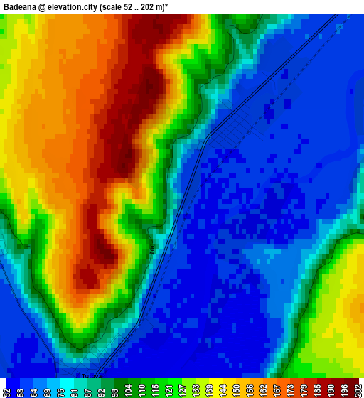
Below is the Elevation map of Bădeana, which displays elevation range with different colors. Scale of the first map is from 52 to 202 m (171 to 663 ft) with average elevation of 104 meters (=341 ft) [note 1]
These maps also provides idea of topography and contour of this city, they are displayed at different zoom levels. More info about maps, scale and edge coordinates you can find below images.
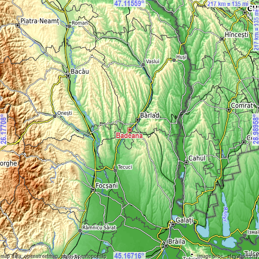
| \ | Map #1 | Topo.Map |
| Scale [m] | 52..202 m | × |
| Scale [ft] | 171..663 ft | × |
| Average | 104 m = 341 ft | × |
| Width | 6.77 km = 4.2 mi | 216.6 km = 134.6 mi |
| Height | 6.77 km = 4.2 mi | 216.6 km = 134.6 mi |
| ↑Max Latitude | 46.180436° | 47.11559° |
| Latitude at center | 46.15° | 46.15° |
| ↓Min Latitude | 46.119547° | 45.16716° |
| ← Min Longitude | 27.539385° | 26.17708° |
| Longitude center | 27.58333° | 27.58333° |
| →Max Longitude | 27.627275° | 28.98958° |
Nearby cities:
Cities around Bădeana sort by population:
• Bârlad elevation 70 m
11.2 km,  35°
35°
• Ghidigeni 102 m
12.8 km,  210°
210°
• Tutova 54 m
4.5 km, 214°
• Griviţa 183 m
5.1 km,  90°
90°
• Iveşti 72 m
5.3 km,  313°
313°
• Bălăşeşti 137 m
8.5 km,  130°
130°
• Trestiana 65 m
7.6 km, 42°
• Pogonești 77 m
3.9 km,  273°
273°
• Ciorăști 109 m
10.8 km,  248°
248°
• Bălăbănești 142 m
12.3 km,  119°
119°
• Ciocani 96 m
12.4 km,  351°
351°
• Pochidia 108 m
11.9 km,  178°
178°
Multilingual:
 En español:
Bădeana elevación 63 m.
 En France:
Bădeana élévation 63 m.


Sources and notes:
- [note 1] Map square and city borders are not equal. Map elevation data is calculated only from area inside that square.
- [src 1] Elevation data from geonames database provided with same terms of usage.
- [src 2] The elevation map of Bădeana is generated using elevation data from NASA's 3 arcsec (90m) resolution SRTM data.
- [src 3] Base (background) map © OpenStreetMap contributors tiles are generated by Geofabrik and OpenTopoMap.
Copyright & License:
This Bădeana Elevation Map is licensed under CC BY-SA. You may reuse any part from this page, if you give a proper credit by linking to this URL:
 More info on terms of use page.