Tutova elevation
Tutova (Vaslui, Comuna Tutova), Romania elevation is 54 meters and Tutova elevation in feet is 177 ft above sea level [src 1]. Tutova is a seat of a second-order administrative division (feature code) with elevation that is 198 meters (650 ft) smaller than average city elevation in Romania.
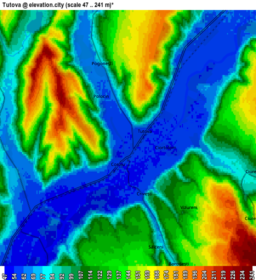
Below is the Elevation map of Tutova, which displays elevation range with different colors. Scale of the first map is from 51 to 224 m (167 to 735 ft) with average elevation of 90.4 meters (=297 ft) [note 1]
These maps also provides idea of topography and contour of this city, they are displayed at different zoom levels. More info about maps, scale and edge coordinates you can find below images.

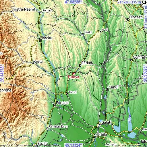
| \ | Map #1 | Map #2 | Topo.Map |
| Scale [m] | 51..224 m | 47..241 m | × |
| Scale [ft] | 167..735 ft | 154..791 ft | × |
| Average | 90.4 m = 297 ft | 108.1 m = 355 ft | × |
| Width | 6.77 km = 4.2 mi | 13.55 km = 8.4 mi | 216.8 km = 134.7 mi |
| Height | 6.77 km = 4.2 mi | 13.55 km = 8.4 mi | 216.8 km = 134.7 mi |
| ↑Max Latitude | 46.147124° | 46.177561° | 47.08285° |
| Latitude at center | 46.11667° | 46.11667° | 46.11667° |
| ↓Min Latitude | 46.086199° | 46.055711° | 45.13324° |
| ← Min Longitude | 27.506055° | 27.462109° | 26.14375° |
| Longitude center | 27.55° | 27.55° | 27.55° |
| →Max Longitude | 27.593945° | 27.637891° | 28.95625° |
Nearby cities:
Cities around Tutova sort by population:
• Ghidigeni elevation 102 m
8.4 km,  207°
207°
• Griviţa 183 m
8.6 km,  64°
64°
• Iveşti 72 m
7.5 km,  350°
350°
• Gohor 106 m
12.8 km,  244°
244°
• Priponeşti 165 m
9.7 km,  247°
247°
• Bălăşeşti 137 m
9.2 km,  101°
101°
• Cerţeşti 236 m
12.3 km,  155°
155°
• Trestiana 65 m
12 km,  39°
39°
• Pogonești 77 m
4.2 km,  340°
340°
• Bădeana 63 m
4.5 km,  34°
34°
• Ciorăști 109 m
7.5 km,  267°
267°
• Pochidia 108 m
8.7 km, 160°
Multilingual:
 En español:
Tutova elevación 54 m.
 En France:
Tutova élévation 54 m.


Sources and notes:
- [note 1] Map square and city borders are not equal. Map elevation data is calculated only from area inside that square.
- [src 1] Elevation data from geonames database provided with same terms of usage.
- [src 2] The elevation map of Tutova is generated using elevation data from NASA's 3 arcsec (90m) resolution SRTM data.
- [src 3] Base (background) map © OpenStreetMap contributors tiles are generated by Geofabrik and OpenTopoMap.
Copyright & License:
This Tutova Elevation Map is licensed under CC BY-SA. You may reuse any part from this page, if you give a proper credit by linking to this URL:
 More info on terms of use page.