Ghidigeni elevation
Ghidigeni (Galaţi, Comuna Ghidigeni), Romania elevation is 102 meters and Ghidigeni elevation in feet is 335 ft above sea level [src 1]. Ghidigeni is a seat of a second-order administrative division (feature code) with elevation that is 150 meters (492 ft) smaller than average city elevation in Romania.
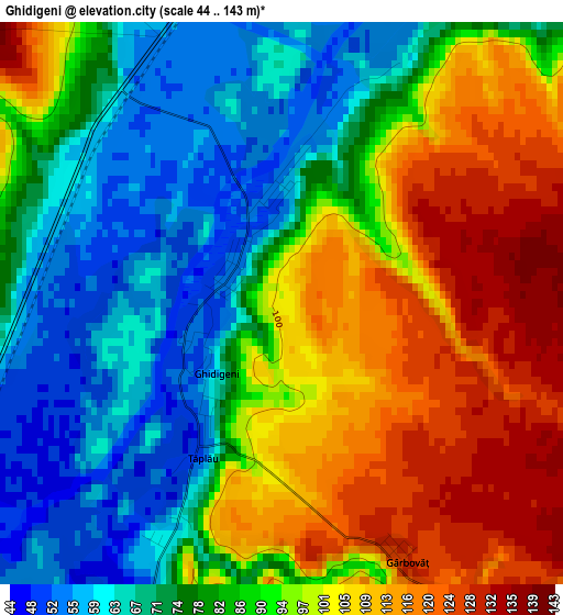
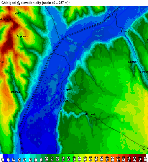
Below is the Elevation map of Ghidigeni, which displays elevation range with different colors. Scale of the first map is from 44 to 143 m (144 to 469 ft) with average elevation of 88.2 meters (=289 ft) [note 1]
These maps also provides idea of topography and contour of this city, they are displayed at different zoom levels. More info about maps, scale and edge coordinates you can find below images.
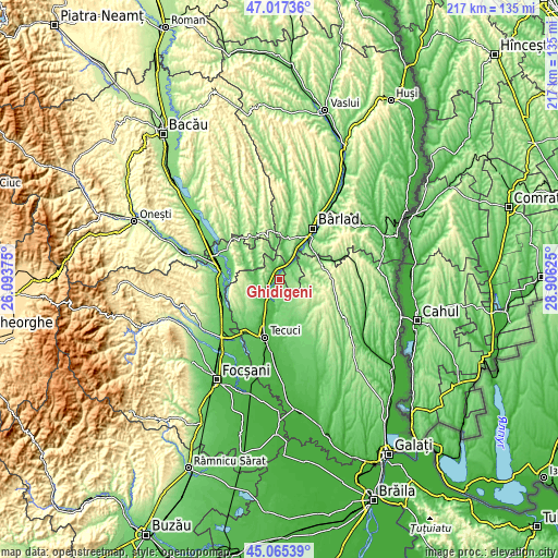
| \ | Map #1 | Map #2 | Topo.Map |
| Scale [m] | 44..143 m | 40..257 m | × |
| Scale [ft] | 144..469 ft | 131..843 ft | × |
| Average | 88.2 m = 289 ft | 109.5 m = 359 ft | × |
| Width | 6.78 km = 4.2 mi | 13.56 km = 8.4 mi | 217 km = 134.8 mi |
| Height | 6.78 km = 4.2 mi | 13.56 km = 8.4 mi | 217 km = 134.8 mi |
| ↑Max Latitude | 46.080491° | 46.110965° | 47.01736° |
| Latitude at center | 46.05° | 46.05° | 46.05° |
| ↓Min Latitude | 46.019492° | 45.988968° | 45.06539° |
| ← Min Longitude | 27.456055° | 27.412109° | 26.09375° |
| Longitude center | 27.5° | 27.5° | 27.5° |
| →Max Longitude | 27.543945° | 27.587891° | 28.90625° |
Nearby cities:
Cities around Ghidigeni sort by population:
• Brăhăşeştii de Sus elevation 117 m
11.6 km,  270°
270°
• Tutova 54 m
8.4 km,  27°
27°
• Gohor 106 m
7.9 km,  283°
283°
• Brăhășești 177 m
10.5 km,  259°
259°
• Priponeşti 165 m
6.3 km,  305°
305°
• Cerţeşti 236 m
9.7 km,  112°
112°
• Tănăsoaia 206 m
11.7 km,  298°
298°
• Tălpigi 48 m
5.1 km,  204°
204°
• Negrilești 47 m
10.4 km,  188°
188°
• Pogonești 77 m
11.6 km,  12°
12°
• Ciorăști 109 m
8 km,  332°
332°
• Pochidia 108 m
6.8 km,  96°
96°
Multilingual:
 En español:
Ghidigeni elevación 102 m.
 En France:
Ghidigeni élévation 102 m.
 Auf Deutsch:
Ghidigeni höhe über dem Meeresspiegel ist 102 m.

Sources and notes:
- [note 1] Map square and city borders are not equal. Map elevation data is calculated only from area inside that square.
- [src 1] Elevation data from geonames database provided with same terms of usage.
- [src 2] The elevation map of Ghidigeni is generated using elevation data from NASA's 3 arcsec (90m) resolution SRTM data.
- [src 3] Base (background) map © OpenStreetMap contributors tiles are generated by Geofabrik and OpenTopoMap.
Copyright & License:
This Ghidigeni Elevation Map is licensed under CC BY-SA. You may reuse any part from this page, if you give a proper credit by linking to this URL:
 More info on terms of use page.