Negrilești elevation
Negrilești (Galaţi, Comuna Negrileşti), Romania elevation is 47 meters and Negrilești elevation in feet is 154 ft above sea level [src 1]. Negrilești is a seat of a second-order administrative division (feature code) with elevation that is 205 meters (673 ft) smaller than average city elevation in Romania.
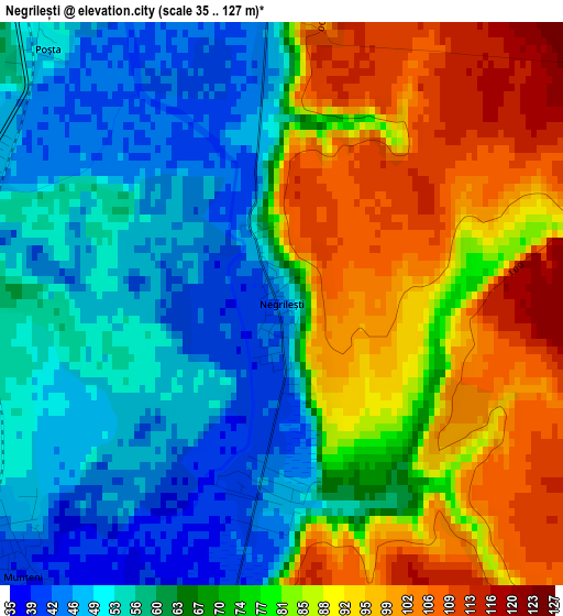
Below is the Elevation map of Negrilești, which displays elevation range with different colors. Scale of the first map is from 35 to 127 m (115 to 417 ft) with average elevation of 72.1 meters (=237 ft) [note 1]
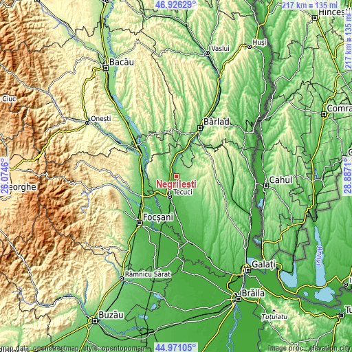
These maps also provides idea of topography and contour of this city, they are displayed at different zoom levels. More info about maps, scale and edge coordinates you can find below images.
| \ | Map #1 | Topo.Map |
| Scale [m] | 35..127 m | × |
| Scale [ft] | 115..417 ft | × |
| Average | 72.1 m = 237 ft | × |
| Width | 6.79 km = 4.2 mi | 217.4 km = 135.1 mi |
| Height | 6.79 km = 4.2 mi | 217.4 km = 135.1 mi |
| ↑Max Latitude | 45.987832° | 46.92629° |
| Latitude at center | 45.95729° | 45.95729° |
| ↓Min Latitude | 45.926731° | 44.97105° |
| ← Min Longitude | 27.436905° | 26.0746° |
| Longitude center | 27.48085° | 27.48085° |
| →Max Longitude | 27.524795° | 28.8871° |
Nearby cities:
Cities around Negrilești sort by population:
• Tecuci elevation 36 m
12.5 km,  196°
196°
• Matca 58 m
12.6 km,  161°
161°
• Munteni 43 m
4.5 km,  234°
234°
• Corod 96 m
12.3 km,  121°
121°
• Ghidigeni 102 m
10.4 km,  8°
8°
• Brăhășești 177 m
12.2 km,  313°
313°
• Ţepu 161 m
8.9 km,  276°
276°
• Cerţeşti 236 m
12.4 km,  57°
57°
• Tălpigi 48 m
5.7 km,  353°
353°
• Ungureni 46 m
5 km,  189°
189°
• Blânzi 131 m
13.3 km,  100°
100°
• Pochidia 108 m
12.6 km,  40°
40°
Multilingual:
 En español:
Negrilești elevación 47 m.
 En France:
Negrilești élévation 47 m.
 Auf Deutsch:
Negrilești höhe über dem Meeresspiegel ist 47 m.

Sources and notes:
- [note 1] Map square and city borders are not equal. Map elevation data is calculated only from area inside that square.
- [src 1] Elevation data from geonames database provided with same terms of usage.
- [src 2] The elevation map of Negrilești is generated using elevation data from NASA's 3 arcsec (90m) resolution SRTM data.
- [src 3] Base (background) map © OpenStreetMap contributors tiles are generated by Geofabrik and OpenTopoMap.
Copyright & License:
This Negrilești Elevation Map is licensed under CC BY-SA. You may reuse any part from this page, if you give a proper credit by linking to this URL:
 More info on terms of use page.