Blânzi elevation
Blânzi (Galaţi, Comuna Corod), Romania elevation is 131 meters and Blânzi elevation in feet is 430 ft above sea level [src 1]. Blânzi is a populated place (feature code) with elevation that is 121 meters (397 ft) smaller than average city elevation in Romania.
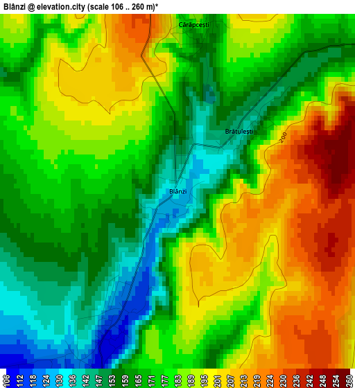
Below is the Elevation map of Blânzi, which displays elevation range with different colors. Scale of the first map is from 106 to 260 m (348 to 853 ft) with average elevation of 179.3 meters (=588 ft) [note 1]
These maps also provides idea of topography and contour of this city, they are displayed at different zoom levels. More info about maps, scale and edge coordinates you can find below images.
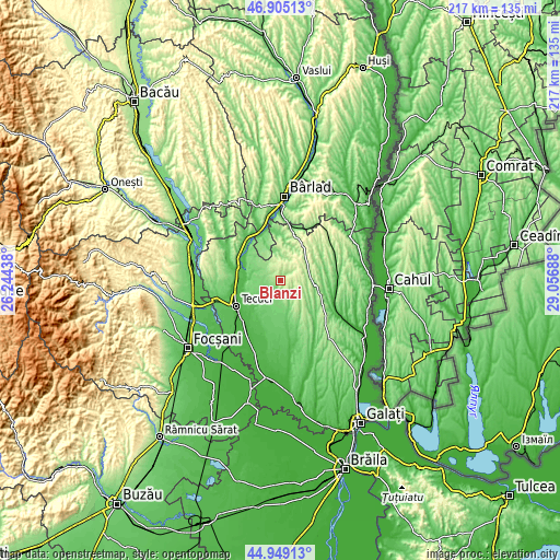
| \ | Map #1 | Topo.Map |
| Scale [m] | 106..260 m | × |
| Scale [ft] | 348..853 ft | × |
| Average | 179.3 m = 588 ft | × |
| Width | 6.8 km = 4.2 mi | 217.5 km = 135.1 mi |
| Height | 6.8 km = 4.2 mi | 217.5 km = 135.1 mi |
| ↑Max Latitude | 45.966304° | 46.90513° |
| Latitude at center | 45.93575° | 45.93575° |
| ↓Min Latitude | 45.905179° | 44.94913° |
| ← Min Longitude | 27.606685° | 26.24438° |
| Longitude center | 27.65063° | 27.65063° |
| →Max Longitude | 27.694575° | 29.05688° |
Nearby cities:
Cities around Blânzi sort by population:
• Matca elevation 58 m
13.2 km,  223°
223°
• Corod 96 m
4.8 km,  213°
213°
• Drăguşeni 272 m
8.4 km,  65°
65°
• Cerţeşti 236 m
9.4 km,  343°
343°
• Corni 212 m
13.1 km,  136°
136°
• Valea Mărului 107 m
11.2 km,  163°
163°
• Smulţi 218 m
7.7 km,  92°
92°
• Negrilești 47 m
13.3 km,  280°
280°
• Ungureni 46 m
14.2 km,  259°
259°
• Mândrești 128 m
7 km,  146°
146°
• Crăiești 205 m
12.5 km, 86°
• Pochidia 108 m
12.9 km, 337°
Multilingual:
 En español:
Blânzi elevación 131 m.
 En France:
Blânzi élévation 131 m.


Sources and notes:
- [note 1] Map square and city borders are not equal. Map elevation data is calculated only from area inside that square.
- [src 1] Elevation data from geonames database provided with same terms of usage.
- [src 2] The elevation map of Blânzi is generated using elevation data from NASA's 3 arcsec (90m) resolution SRTM data.
- [src 3] Base (background) map © OpenStreetMap contributors tiles are generated by Geofabrik and OpenTopoMap.
Copyright & License:
This Blânzi Elevation Map is licensed under CC BY-SA. You may reuse any part from this page, if you give a proper credit by linking to this URL:
 More info on terms of use page.