Drăguşeni elevation
Drăguşeni (Galaţi, Comuna Drăguşeni), Romania elevation is 272 meters and Drăguşeni elevation in feet is 892 ft above sea level [src 1]. Drăguşeni is a seat of a second-order administrative division (feature code) with elevation that is 20 meters (66 ft) bigger than average city elevation in Romania.
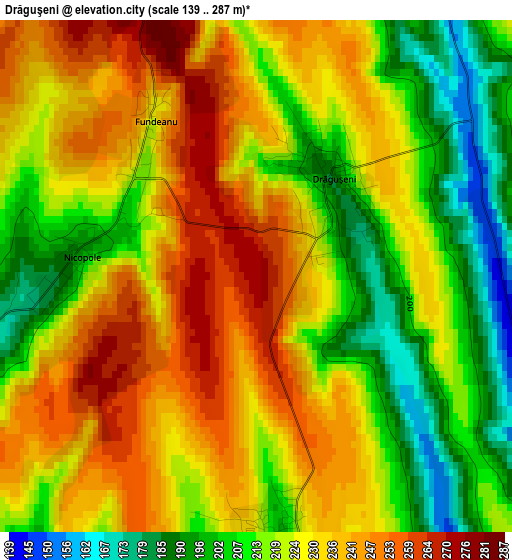
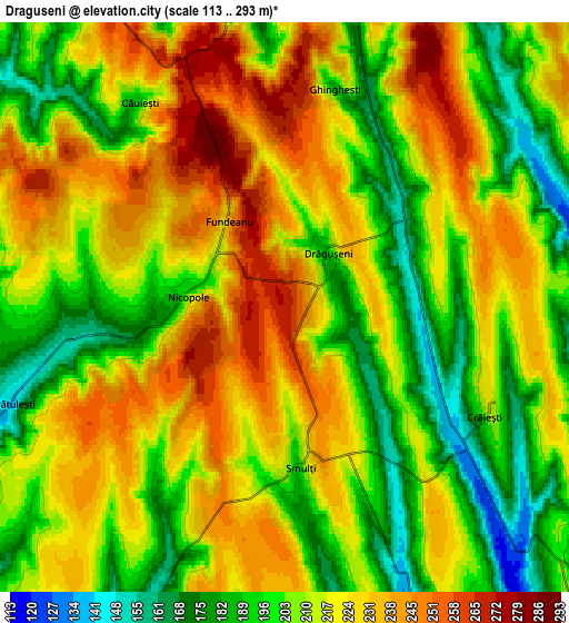
Below is the Elevation map of Drăguşeni, which displays elevation range with different colors. Scale of the first map is from 139 to 287 m (456 to 942 ft) with average elevation of 224.5 meters (=737 ft) [note 1]
These maps also provides idea of topography and contour of this city, they are displayed at different zoom levels. More info about maps, scale and edge coordinates you can find below images.
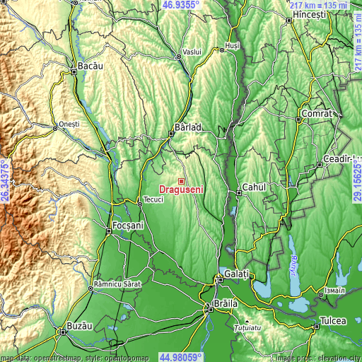
| \ | Map #1 | Map #2 | Topo.Map |
| Scale [m] | 139..287 m | 113..293 m | × |
| Scale [ft] | 456..942 ft | 371..961 ft | × |
| Average | 224.5 m = 737 ft | 213.6 m = 701 ft | × |
| Width | 6.79 km = 4.2 mi | 13.59 km = 8.4 mi | 217.4 km = 135.1 mi |
| Height | 6.79 km = 4.2 mi | 13.59 km = 8.4 mi | 217.4 km = 135.1 mi |
| ↑Max Latitude | 45.997207° | 46.027727° | 46.9355° |
| Latitude at center | 45.96667° | 45.96667° | 45.96667° |
| ↓Min Latitude | 45.936116° | 45.905546° | 44.98059° |
| ← Min Longitude | 27.706055° | 27.662109° | 26.34375° |
| Longitude center | 27.75° | 27.75° | 27.75° |
| →Max Longitude | 27.793945° | 27.837891° | 29.15625° |
Nearby cities:
Cities around Drăguşeni sort by population:
• Corod elevation 96 m
12.7 km,  234°
234°
• Cerţeşti 236 m
11.7 km,  298°
298°
• Corni 212 m
13 km,  174°
174°
• Vârlezi 130 m
10.7 km,  133°
133°
• Băneasa 67 m
14.6 km,  104°
104°
• Jorăşti 166 m
9.2 km,  78°
78°
• Smulţi 218 m
3.7 km,  180°
180°
• Rădești 211 m
12.2 km,  14°
14°
• Blânzi 131 m
8.4 km,  245°
245°
• Mândrești 128 m
10 km,  202°
202°
• Crăiești 205 m
5.4 km,  118°
118°
• Bălăbănești 142 m
14.5 km,  351°
351°
Multilingual:
 En español:
Drăguşeni elevación 272 m.
 En France:
Drăguşeni élévation 272 m.
 Auf Deutsch:
Drăguşeni höhe über dem Meeresspiegel ist 272 m.

Sources and notes:
- [note 1] Map square and city borders are not equal. Map elevation data is calculated only from area inside that square.
- [src 1] Elevation data from geonames database provided with same terms of usage.
- [src 2] The elevation map of Drăguşeni is generated using elevation data from NASA's 3 arcsec (90m) resolution SRTM data.
- [src 3] Base (background) map © OpenStreetMap contributors tiles are generated by Geofabrik and OpenTopoMap.
Copyright & License:
This Drăguşeni Elevation Map is licensed under CC BY-SA. You may reuse any part from this page, if you give a proper credit by linking to this URL:
 More info on terms of use page.