Mândrești elevation
Mândrești (Galaţi, Comuna Valea Mãrului), Romania elevation is 128 meters and Mândrești elevation in feet is 420 ft above sea level [src 1]. Mândrești is a populated place (feature code) with elevation that is 124 meters (407 ft) smaller than average city elevation in Romania.
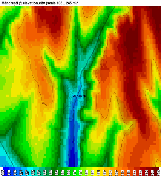
Below is the Elevation map of Mândrești, which displays elevation range with different colors. Scale of the first map is from 105 to 245 m (344 to 804 ft) with average elevation of 189 meters (=620 ft) [note 1]
These maps also provides idea of topography and contour of this city, they are displayed at different zoom levels. More info about maps, scale and edge coordinates you can find below images.
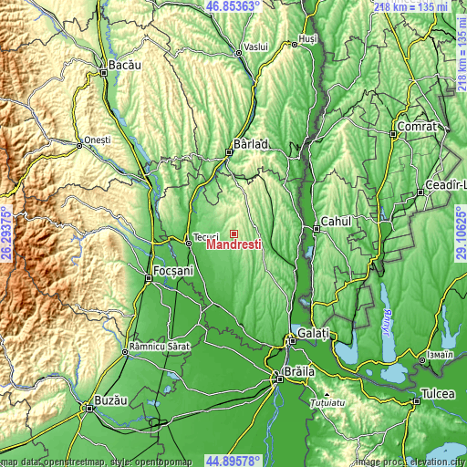
| \ | Map #1 | Topo.Map |
| Scale [m] | 105..245 m | × |
| Scale [ft] | 344..804 ft | × |
| Average | 189 m = 620 ft | × |
| Width | 6.8 km = 4.2 mi | 217.7 km = 135.3 mi |
| Height | 6.8 km = 4.2 mi | 217.7 km = 135.3 mi |
| ↑Max Latitude | 45.913913° | 46.85363° |
| Latitude at center | 45.88333° | 45.88333° |
| ↓Min Latitude | 45.85273° | 44.89578° |
| ← Min Longitude | 27.656055° | 26.29375° |
| Longitude center | 27.7° | 27.7° |
| →Max Longitude | 27.743945° | 29.10625° |
Nearby cities:
Cities around Mândrești sort by population:
• Matca elevation 58 m
13.4 km,  253°
253°
• Cudalbi 97 m
11.1 km,  180°
180°
• Corod 96 m
6.7 km,  286°
286°
• Drăguşeni 272 m
10 km,  22°
22°
• Târgu Bujor 137 m
15.6 km,  96°
96°
• Băleni 121 m
12.7 km,  125°
125°
• Corni 212 m
6.4 km, 125°
• Valea Mărului 107 m
5 km,  187°
187°
• Vârlezi 130 m
11.8 km,  80°
80°
• Smulţi 218 m
6.8 km,  34°
34°
• Blânzi 131 m
7 km,  326°
326°
• Crăiești 205 m
10.9 km,  52°
52°
Multilingual:
 En español:
Mândrești elevación 128 m.
 En France:
Mândrești élévation 128 m.
 Auf Deutsch:
Mândrești höhe über dem Meeresspiegel ist 128 m.

Sources and notes:
- [note 1] Map square and city borders are not equal. Map elevation data is calculated only from area inside that square.
- [src 1] Elevation data from geonames database provided with same terms of usage.
- [src 2] The elevation map of Mândrești is generated using elevation data from NASA's 3 arcsec (90m) resolution SRTM data.
- [src 3] Base (background) map © OpenStreetMap contributors tiles are generated by Geofabrik and OpenTopoMap.
Copyright & License:
This Mândrești Elevation Map is licensed under CC BY-SA. You may reuse any part from this page, if you give a proper credit by linking to this URL:
 More info on terms of use page.