Munteni elevation
Munteni (Galaţi, Comuna Munteni), Romania elevation is 43 meters and Munteni elevation in feet is 141 ft above sea level [src 1]. Munteni is a seat of a second-order administrative division (feature code) with elevation that is 209 meters (686 ft) smaller than average city elevation in Romania.
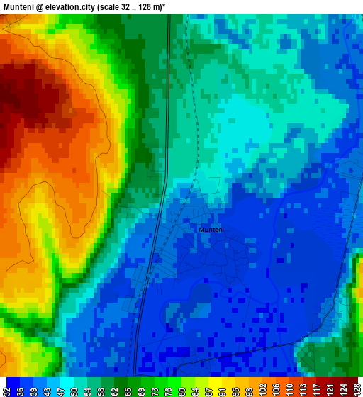
Below is the Elevation map of Munteni, which displays elevation range with different colors. Scale of the first map is from 32 to 128 m (105 to 420 ft) with average elevation of 59.9 meters (=197 ft) [note 1]
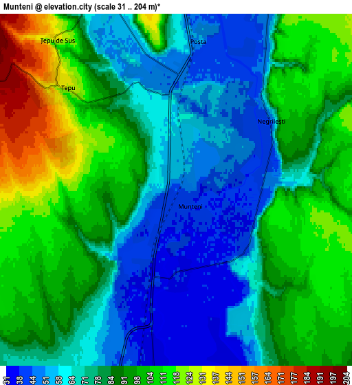
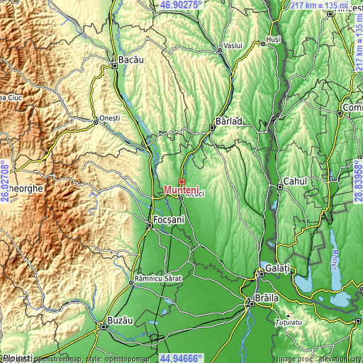
These maps also provides idea of topography and contour of this city, they are displayed at different zoom levels. More info about maps, scale and edge coordinates you can find below images.
| \ | Map #1 | Map #2 | Topo.Map |
| Scale [m] | 32..128 m | 31..204 m | × |
| Scale [ft] | 105..420 ft | 102..669 ft | × |
| Average | 59.9 m = 197 ft | 83.7 m = 275 ft | × |
| Width | 6.8 km = 4.2 mi | 13.59 km = 8.4 mi | 217.5 km = 135.1 mi |
| Height | 6.8 km = 4.2 mi | 13.59 km = 8.4 mi | 217.5 km = 135.1 mi |
| ↑Max Latitude | 45.963885° | 45.994424° | 46.90275° |
| Latitude at center | 45.93333° | 45.93333° | 45.93333° |
| ↓Min Latitude | 45.902758° | 45.872169° | 44.94666° |
| ← Min Longitude | 27.389385° | 27.345439° | 26.02708° |
| Longitude center | 27.43333° | 27.43333° | 27.43333° |
| →Max Longitude | 27.477275° | 27.521221° | 28.83958° |
Nearby cities:
Cities around Munteni sort by population:
• Tecuci elevation 36 m
9.3 km,  179°
179°
• Matca 58 m
12.1 km,  140°
140°
• Cosmeşti 81 m
11.8 km,  233°
233°
• Ghidigeni 102 m
14 km,  21°
21°
• Nicoreşti 131 m
9.6 km,  269°
269°
• Buciumeni 203 m
12.7 km,  305°
305°
• Brăhășești 177 m
12.3 km,  335°
335°
• Ţepu 161 m
6.3 km, 305°
• Tălpigi 48 m
8.8 km, 20°
• Negrilești 47 m
4.5 km,  54°
54°
• Ungureni 46 m
3.6 km,  128°
128°
• Cosmeștii-Vale 52 m
13.3 km,  237°
237°
Multilingual:
 En español:
Munteni elevación 43 m.
 En France:
Munteni élévation 43 m.


Sources and notes:
- [note 1] Map square and city borders are not equal. Map elevation data is calculated only from area inside that square.
- [src 1] Elevation data from geonames database provided with same terms of usage.
- [src 2] The elevation map of Munteni is generated using elevation data from NASA's 3 arcsec (90m) resolution SRTM data.
- [src 3] Base (background) map © OpenStreetMap contributors tiles are generated by Geofabrik and OpenTopoMap.
Copyright & License:
This Munteni Elevation Map is licensed under CC BY-SA. You may reuse any part from this page, if you give a proper credit by linking to this URL:
 More info on terms of use page.