Cosmeștii-Vale elevation
Cosmeștii-Vale (Galaţi, Comuna Cosmeşti), Romania elevation is 52 meters and Cosmeștii-Vale elevation in feet is 171 ft above sea level [src 1]. Cosmeștii-Vale is a populated place (feature code) with elevation that is 200 meters (656 ft) smaller than average city elevation in Romania.
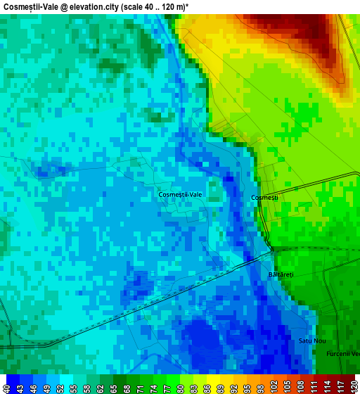
Below is the Elevation map of Cosmeștii-Vale, which displays elevation range with different colors. Scale of the first map is from 40 to 120 m (131 to 394 ft) with average elevation of 62.1 meters (=204 ft) [note 1]
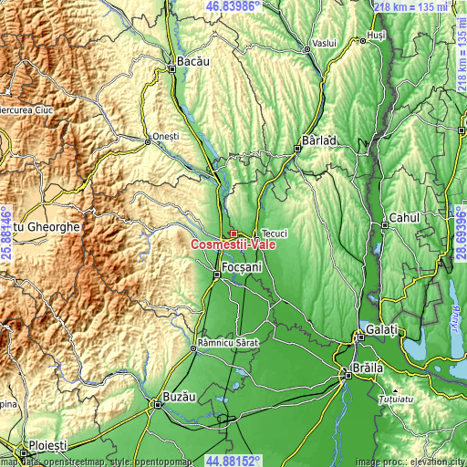
These maps also provides idea of topography and contour of this city, they are displayed at different zoom levels. More info about maps, scale and edge coordinates you can find below images.
| \ | Map #1 | Topo.Map |
| Scale [m] | 40..120 m | × |
| Scale [ft] | 131..394 ft | × |
| Average | 62.1 m = 204 ft | × |
| Width | 6.8 km = 4.2 mi | 217.7 km = 135.3 mi |
| Height | 6.8 km = 4.2 mi | 217.7 km = 135.3 mi |
| ↑Max Latitude | 45.899901° | 46.83986° |
| Latitude at center | 45.86931° | 45.86931° |
| ↓Min Latitude | 45.838703° | 44.88152° |
| ← Min Longitude | 27.243765° | 25.88146° |
| Longitude center | 27.28771° | 27.28771° |
| →Max Longitude | 27.331655° | 28.69396° |
Nearby cities:
Cities around Cosmeștii-Vale sort by population:
• Tecuci elevation 36 m
11.6 km,  100°
100°
• Munteni 43 m
13.3 km,  57°
57°
• Mărășești 58 m
4.5 km,  290°
290°
• Cosmeşti 81 m
1.8 km,  86°
86°
• Nicoreşti 131 m
7.2 km,  13°
13°
• Garoafa 68 m
11.7 km,  215°
215°
• Movileni 50 m
13.6 km,  151°
151°
• Ţepu 161 m
12.4 km,  29°
29°
• Furcenii Noi 62 m
7.6 km, 148°
• Ciușlea 45 m
9.2 km,  170°
170°
• Igești 87 m
9.8 km,  236°
236°
• Mirceștii Noi 43 m
13.2 km,  185°
185°
Multilingual:
 En español:
Cosmeștii-Vale elevación 52 m.
 En France:
Cosmeștii-Vale élévation 52 m.
 Auf Deutsch:
Cosmeștii-Vale höhe über dem Meeresspiegel ist 52 m.

Sources and notes:
- [note 1] Map square and city borders are not equal. Map elevation data is calculated only from area inside that square.
- [src 1] Elevation data from geonames database provided with same terms of usage.
- [src 2] The elevation map of Cosmeștii-Vale is generated using elevation data from NASA's 3 arcsec (90m) resolution SRTM data.
- [src 3] Base (background) map © OpenStreetMap contributors tiles are generated by Geofabrik and OpenTopoMap.
Copyright & License:
This Cosmeștii-Vale Elevation Map is licensed under CC BY-SA. You may reuse any part from this page, if you give a proper credit by linking to this URL:
 More info on terms of use page.