Garoafa elevation
Garoafa (Vrancea, Comuna Garoafa), Romania elevation is 68 meters and Garoafa elevation in feet is 223 ft above sea level [src 1]. Garoafa is a seat of a second-order administrative division (feature code) with elevation that is 184 meters (604 ft) smaller than average city elevation in Romania.
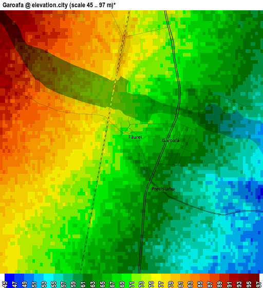
Below is the Elevation map of Garoafa, which displays elevation range with different colors. Scale of the first map is from 45 to 97 m (148 to 318 ft) with average elevation of 69.4 meters (=228 ft) [note 1]
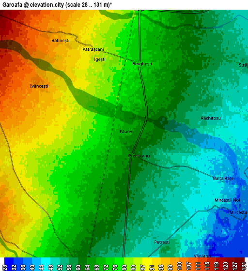
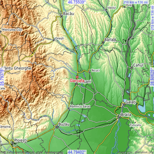
These maps also provides idea of topography and contour of this city, they are displayed at different zoom levels. More info about maps, scale and edge coordinates you can find below images.
| \ | Map #1 | Map #2 | Topo.Map |
| Scale [m] | 45..97 m | 28..131 m | × |
| Scale [ft] | 148..318 ft | 92..430 ft | × |
| Average | 69.4 m = 228 ft | 70.6 m = 232 ft | × |
| Width | 6.82 km = 4.2 mi | 13.63 km = 8.5 mi | 218.1 km = 135.5 mi |
| Height | 6.82 km = 4.2 mi | 13.63 km = 8.5 mi | 218.1 km = 135.5 mi |
| ↑Max Latitude | 45.813968° | 45.844589° | 46.75539° |
| Latitude at center | 45.78333° | 45.78333° | 45.78333° |
| ↓Min Latitude | 45.752675° | 45.722004° | 44.79402° |
| ← Min Longitude | 27.156055° | 27.112109° | 25.79375° |
| Longitude center | 27.2° | 27.2° | 27.2° |
| →Max Longitude | 27.243945° | 27.287891° | 28.60625° |
Nearby cities:
Cities around Garoafa sort by population:
• Focșani elevation 54 m
9.4 km,  187°
187°
• Vânători 45 m
6.8 km,  145°
145°
• Jariştea 153 m
10.3 km,  270°
270°
• Slobozia-Câmpineanca 70 m
10.6 km,  209°
209°
• Câmpineanca 82 m
9.7 km, 214°
• Unirea 109 m
8.6 km,  236°
236°
• Jorăști 38 m
9.1 km, 147°
• Ciușlea 45 m
8.3 km,  86°
86°
• Igești 87 m
4.3 km,  341°
341°
• Mirceștii Noi 43 m
6.7 km,  122°
122°
• Oleșești 148 m
10.5 km,  313°
313°
• Vârteşcoiu 122 m
10.6 km, 238°
Multilingual:
 En español:
Garoafa elevación 68 m.
 En France:
Garoafa élévation 68 m.


Sources and notes:
- [note 1] Map square and city borders are not equal. Map elevation data is calculated only from area inside that square.
- [src 1] Elevation data from geonames database provided with same terms of usage.
- [src 2] The elevation map of Garoafa is generated using elevation data from NASA's 3 arcsec (90m) resolution SRTM data.
- [src 3] Base (background) map © OpenStreetMap contributors tiles are generated by Geofabrik and OpenTopoMap.
Copyright & License:
This Garoafa Elevation Map is licensed under CC BY-SA. You may reuse any part from this page, if you give a proper credit by linking to this URL:
 More info on terms of use page.