Câmpineanca elevation
Câmpineanca (Vrancea, Comuna Câmpineanca), Romania elevation is 82 meters and Câmpineanca elevation in feet is 269 ft above sea level [src 1]. Câmpineanca is a seat of a second-order administrative division (feature code) with elevation that is 170 meters (558 ft) smaller than average city elevation in Romania.
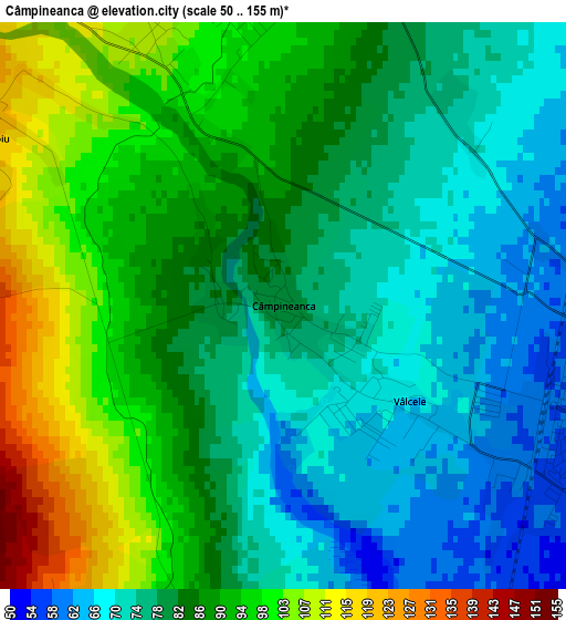
Below is the Elevation map of Câmpineanca, which displays elevation range with different colors. Scale of the first map is from 50 to 155 m (164 to 509 ft) with average elevation of 84.5 meters (=277 ft) [note 1]
These maps also provides idea of topography and contour of this city, they are displayed at different zoom levels. More info about maps, scale and edge coordinates you can find below images.
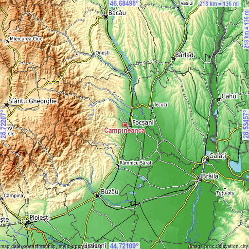
| \ | Map #1 | Topo.Map |
| Scale [m] | 50..155 m | × |
| Scale [ft] | 164..509 ft | × |
| Average | 84.5 m = 277 ft | × |
| Width | 6.82 km = 4.2 mi | 218.4 km = 135.7 mi |
| Height | 6.82 km = 4.2 mi | 218.4 km = 135.7 mi |
| ↑Max Latitude | 45.742337° | 46.68498° |
| Latitude at center | 45.71166° | 45.71166° |
| ↓Min Latitude | 45.680966° | 44.72109° |
| ← Min Longitude | 27.084375° | 25.72207° |
| Longitude center | 27.12832° | 27.12832° |
| →Max Longitude | 27.172265° | 28.53457° |
Nearby cities:
Cities around Câmpineanca sort by population:
• Focșani elevation 54 m
4.5 km,  106°
106°
• Odobeşti 223 m
8.6 km,  315°
315°
• Coteşti 246 m
9.2 km,  221°
221°
• Garoafa 68 m
9.7 km,  34°
34°
• Jariştea 153 m
9.3 km,  329°
329°
• Goleşti 69 m
5 km,  175°
175°
• Slobozia-Câmpineanca 70 m
1.4 km,  163°
163°
• Cârligele 119 m
3.8 km,  214°
214°
• Broşteni 285 m
8.5 km,  300°
300°
• Unirea 109 m
3.6 km, 332°
• Ceardac 54 m
5.5 km,  147°
147°
• Vârteşcoiu 122 m
4.2 km, 304°
Multilingual:
 En español:
Câmpineanca elevación 82 m.
 En France:
Câmpineanca élévation 82 m.
 Auf Deutsch:
Câmpineanca höhe über dem Meeresspiegel ist 82 m.

Sources and notes:
- [note 1] Map square and city borders are not equal. Map elevation data is calculated only from area inside that square.
- [src 1] Elevation data from geonames database provided with same terms of usage.
- [src 2] The elevation map of Câmpineanca is generated using elevation data from NASA's 3 arcsec (90m) resolution SRTM data.
- [src 3] Base (background) map © OpenStreetMap contributors tiles are generated by Geofabrik and OpenTopoMap.
Copyright & License:
This Câmpineanca Elevation Map is licensed under CC BY-SA. You may reuse any part from this page, if you give a proper credit by linking to this URL:
 More info on terms of use page.