Oleșești elevation
Oleșești (Vrancea, Comuna Ţifeşti), Romania elevation is 148 meters and Oleșești elevation in feet is 486 ft above sea level [src 1]. Oleșești is a populated place (feature code) with elevation that is 104 meters (341 ft) smaller than average city elevation in Romania.
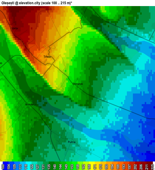
Below is the Elevation map of Oleșești, which displays elevation range with different colors. Scale of the first map is from 100 to 215 m (328 to 705 ft) with average elevation of 142.6 meters (=468 ft) [note 1]
These maps also provides idea of topography and contour of this city, they are displayed at different zoom levels. More info about maps, scale and edge coordinates you can find below images.
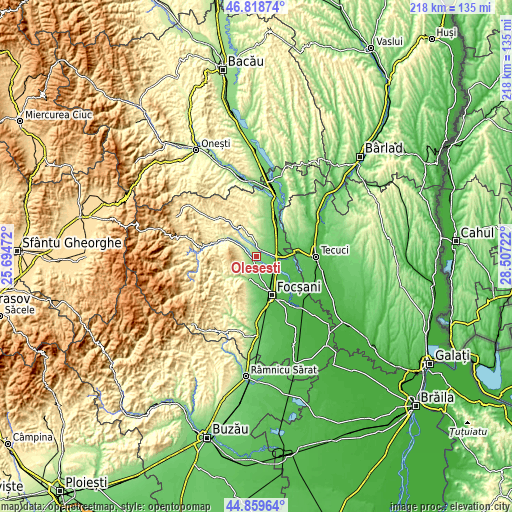
| \ | Map #1 | Topo.Map |
| Scale [m] | 100..215 m | × |
| Scale [ft] | 328..705 ft | × |
| Average | 142.6 m = 468 ft | × |
| Width | 6.81 km = 4.2 mi | 217.8 km = 135.3 mi |
| Height | 6.81 km = 4.2 mi | 217.8 km = 135.3 mi |
| ↑Max Latitude | 45.878412° | 46.81874° |
| Latitude at center | 45.84781° | 45.84781° |
| ↓Min Latitude | 45.817191° | 44.85964° |
| ← Min Longitude | 27.057025° | 25.69472° |
| Longitude center | 27.10097° | 27.10097° |
| →Max Longitude | 27.144915° | 28.50722° |
Nearby cities:
Cities around Oleșești sort by population:
• Mărășești elevation 58 m
11 km,  68°
68°
• Panciu 201 m
6 km,  346°
346°
• Odobeşti 223 m
9.8 km,  203°
203°
• Ţifeşti 150 m
0.3 km,  342°
342°
• Garoafa 68 m
10.5 km,  133°
133°
• Boloteşti 148 m
3.1 km,  238°
238°
• Jariştea 153 m
7.6 km, 200°
• Străoane 326 m
10.3 km, 337°
• Moviliţa 190 m
11.4 km,  359°
359°
• Unirea 109 m
12 km,  177°
177°
• Găgești 155 m
3.6 km,  284°
284°
• Igești 87 m
7 km,  115°
115°
Multilingual:
 En español:
Oleșești elevación 148 m.
 En France:
Oleșești élévation 148 m.
 Auf Deutsch:
Oleșești höhe über dem Meeresspiegel ist 148 m.

Sources and notes:
- [note 1] Map square and city borders are not equal. Map elevation data is calculated only from area inside that square.
- [src 1] Elevation data from geonames database provided with same terms of usage.
- [src 2] The elevation map of Oleșești is generated using elevation data from NASA's 3 arcsec (90m) resolution SRTM data.
- [src 3] Base (background) map © OpenStreetMap contributors tiles are generated by Geofabrik and OpenTopoMap.
Copyright & License:
This Oleșești Elevation Map is licensed under CC BY-SA. You may reuse any part from this page, if you give a proper credit by linking to this URL:
 More info on terms of use page.