Griviţa elevation
Griviţa (Vaslui, Comuna Griviţa), Romania elevation is 183 meters and Griviţa elevation in feet is 600 ft above sea level [src 1]. Griviţa is a seat of a second-order administrative division (feature code) with elevation that is 69 meters (226 ft) smaller than average city elevation in Romania.
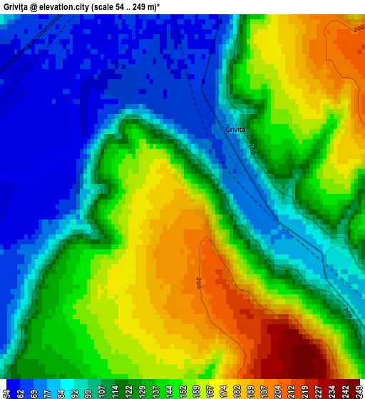
Below is the Elevation map of Griviţa, which displays elevation range with different colors. Scale of the first map is from 54 to 249 m (177 to 817 ft) with average elevation of 126.3 meters (=414 ft) [note 1]
These maps also provides idea of topography and contour of this city, they are displayed at different zoom levels. More info about maps, scale and edge coordinates you can find below images.
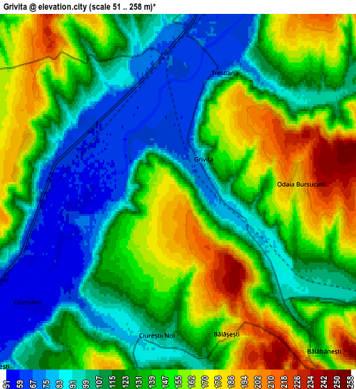
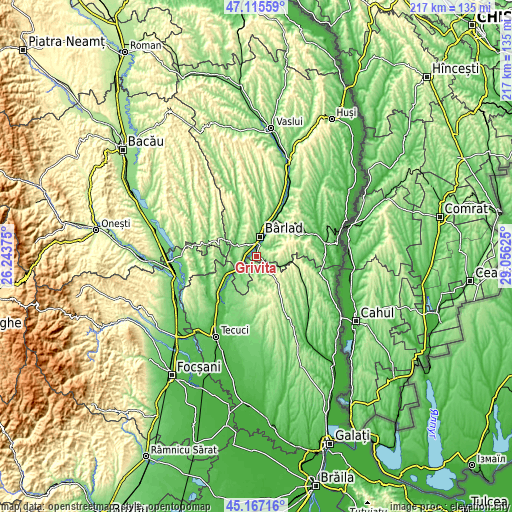
| \ | Map #1 | Map #2 | Topo.Map |
| Scale [m] | 54..249 m | 51..258 m | × |
| Scale [ft] | 177..817 ft | 167..846 ft | × |
| Average | 126.3 m = 414 ft | 130.1 m = 427 ft | × |
| Width | 6.77 km = 4.2 mi | 13.54 km = 8.4 mi | 216.6 km = 134.6 mi |
| Height | 6.77 km = 4.2 mi | 13.54 km = 8.4 mi | 216.6 km = 134.6 mi |
| ↑Max Latitude | 46.180436° | 46.210855° | 47.11559° |
| Latitude at center | 46.15° | 46.15° | 46.15° |
| ↓Min Latitude | 46.119547° | 46.089078° | 45.16716° |
| ← Min Longitude | 27.606055° | 27.562109° | 26.24375° |
| Longitude center | 27.65° | 27.65° | 27.65° |
| →Max Longitude | 27.693945° | 27.737891° | 29.05625° |
Nearby cities:
Cities around Griviţa sort by population:
• Bârlad elevation 70 m
9.2 km,  9°
9°
• Tutova 54 m
8.6 km,  244°
244°
• Vinderei 239 m
11.6 km,  90°
90°
• Iveşti 72 m
9.7 km,  292°
292°
• Bălăşeşti 137 m
5.7 km,  166°
166°
• Rădești 211 m
13.8 km,  128°
128°
• Trestiana 65 m
5.6 km,  0°
0°
• Pogonești 77 m
9.1 km,  271°
271°
• Bădeana 63 m
5.1 km, 270°
• Fruntișeni 136 m
11.1 km,  55°
55°
• Bălăbănești 142 m
8.2 km,  137°
137°
• Pochidia 108 m
12.8 km,  202°
202°
Multilingual:
 En español:
Griviţa elevación 183 m.
 En France:
Griviţa élévation 183 m.


Sources and notes:
- [note 1] Map square and city borders are not equal. Map elevation data is calculated only from area inside that square.
- [src 1] Elevation data from geonames database provided with same terms of usage.
- [src 2] The elevation map of Griviţa is generated using elevation data from NASA's 3 arcsec (90m) resolution SRTM data.
- [src 3] Base (background) map © OpenStreetMap contributors tiles are generated by Geofabrik and OpenTopoMap.
Copyright & License:
This Griviţa Elevation Map is licensed under CC BY-SA. You may reuse any part from this page, if you give a proper credit by linking to this URL:
 More info on terms of use page.