Bălușești elevation
Bălușești (Neamţ, Comuna Icuseşti), Romania elevation is 261 meters and Bălușești elevation in feet is 856 ft above sea level [src 1]. Bălușești is a populated place (feature code) with elevation that is 9 meters (30 ft) bigger than average city elevation in Romania.
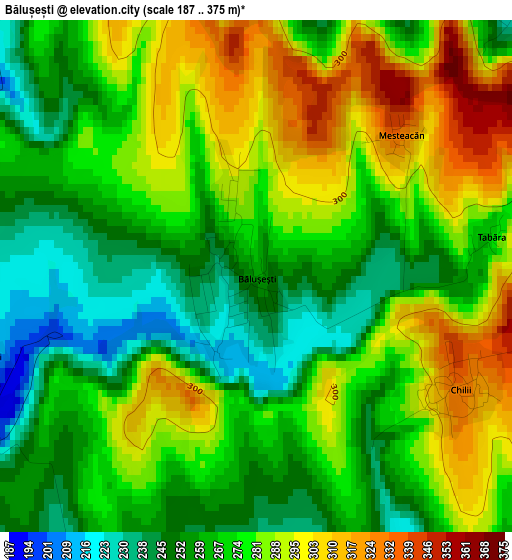
Below is the Elevation map of Bălușești, which displays elevation range with different colors. Scale of the first map is from 187 to 375 m (614 to 1230 ft) with average elevation of 274.2 meters (=900 ft) [note 1]
These maps also provides idea of topography and contour of this city, they are displayed at different zoom levels. More info about maps, scale and edge coordinates you can find below images.
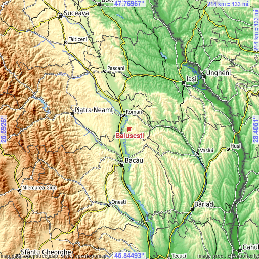
| \ | Map #1 | Topo.Map |
| Scale [m] | 187..375 m | × |
| Scale [ft] | 614..1230 ft | × |
| Average | 274.2 m = 900 ft | × |
| Width | 6.69 km = 4.2 mi | 214 km = 133 mi |
| Height | 6.69 km = 4.2 mi | 214 km = 133 mi |
| ↑Max Latitude | 46.845975° | 47.76967° |
| Latitude at center | 46.81591° | 46.81591° |
| ↓Min Latitude | 46.785828° | 45.84493° |
| ← Min Longitude | 26.954905° | 25.5926° |
| Longitude center | 26.99885° | 26.99885° |
| →Max Longitude | 27.042795° | 28.4051° |
Nearby cities:
Cities around Bălușești sort by population:
• Filipeşti elevation 173 m
11.4 km,  230°
230°
• Icuseşti 169 m
5.3 km,  250°
250°
• Valea Ursului 278 m
6.4 km,  89°
89°
• Oniceni 334 m
11.5 km, 89°
• Horia 186 m
11.8 km,  329°
329°
• Poienari 235 m
12.6 km,  50°
50°
• Cotu Vameș 184 m
10.5 km,  341°
341°
• Bozieni 272 m
11.7 km,  80°
80°
• Ion Creangă 187 m
6.2 km,  346°
346°
• Dămieneşti 178 m
9.3 km,  187°
187°
• Cârligi 208 m
12.6 km,  243°
243°
• Chilii 330 m
3.1 km,  119°
119°
Multilingual:
 En español:
Bălușești elevación 261 m.
 En France:
Bălușești élévation 261 m.
 Auf Deutsch:
Bălușești höhe über dem Meeresspiegel ist 261 m.

Sources and notes:
- [note 1] Map square and city borders are not equal. Map elevation data is calculated only from area inside that square.
- [src 1] Elevation data from geonames database provided with same terms of usage.
- [src 2] The elevation map of Bălușești is generated using elevation data from NASA's 3 arcsec (90m) resolution SRTM data.
- [src 3] Base (background) map © OpenStreetMap contributors tiles are generated by Geofabrik and OpenTopoMap.
Copyright & License:
This Bălușești Elevation Map is licensed under CC BY-SA. You may reuse any part from this page, if you give a proper credit by linking to this URL:
 More info on terms of use page.