Boţeşti elevation
Boţeşti (Arges, Comuna Boţeşti), Romania elevation is 465 meters and Boţeşti elevation in feet is 1526 ft above sea level [src 1]. Boţeşti is a seat of a second-order administrative division (feature code) with elevation that is 213 meters (699 ft) bigger than average city elevation in Romania.
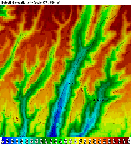
Below is the Elevation map of Boţeşti, which displays elevation range with different colors. Scale of the first map is from 377 to 580 m (1237 to 1903 ft) with average elevation of 499.7 meters (=1639 ft) [note 1]
These maps also provides idea of topography and contour of this city, they are displayed at different zoom levels. More info about maps, scale and edge coordinates you can find below images.
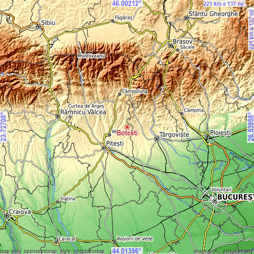
| \ | Map #1 | Topo.Map |
| Scale [m] | 377..580 m | × |
| Scale [ft] | 1237..1903 ft | × |
| Average | 499.7 m = 1639 ft | × |
| Width | 6.91 km = 4.3 mi | 221.1 km = 137.4 mi |
| Height | 6.91 km = 4.3 mi | 221.1 km = 137.4 mi |
| ↑Max Latitude | 45.047727° | 46.00212° |
| Latitude at center | 45.01667° | 45.01667° |
| ↓Min Latitude | 44.985597° | 44.01396° |
| ← Min Longitude | 25.089385° | 23.72708° |
| Longitude center | 25.13333° | 25.13333° |
| →Max Longitude | 25.177275° | 26.53958° |
Nearby cities:
Cities around Boţeşti sort by population:
• Izvoarele elevation 363 m
10.6 km,  79°
79°
• Tătărani 408 m
10.6 km,  100°
100°
• Titeşti 419 m
10.5 km,  270°
270°
• Davideşti 452 m
7.9 km, 270°
• Vulturești 420 m
6.8 km,  324°
324°
• Dobreşti 403 m
5.6 km,  180°
180°
• Dragodănești 393 m
9.2 km,  61°
61°
• Conțești 354 m
10.3 km,  249°
249°
• Scheiu de Jos 334 m
10.5 km,  150°
150°
• Priboiu 388 m
9.9 km, 81°
• Scheiu de Sus 344 m
8.2 km, 145°
• Cândeşti Vale 442 m
9.9 km,  41°
41°
Multilingual:
 En español:
Boţeşti elevación 465 m.
 En France:
Boţeşti élévation 465 m.


Sources and notes:
- [note 1] Map square and city borders are not equal. Map elevation data is calculated only from area inside that square.
- [src 1] Elevation data from geonames database provided with same terms of usage.
- [src 2] The elevation map of Boţeşti is generated using elevation data from NASA's 3 arcsec (90m) resolution SRTM data.
- [src 3] Base (background) map © OpenStreetMap contributors tiles are generated by Geofabrik and OpenTopoMap.
Copyright & License:
This Boţeşti Elevation Map is licensed under CC BY-SA. You may reuse any part from this page, if you give a proper credit by linking to this URL:
 More info on terms of use page.