Dobreşti elevation
Dobreşti (Arges, Comuna Dobreşti), Romania elevation is 403 meters and Dobreşti elevation in feet is 1322 ft above sea level [src 1]. Dobreşti is a seat of a second-order administrative division (feature code) with elevation that is 151 meters (495 ft) bigger than average city elevation in Romania.
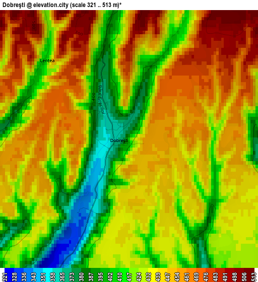
Below is the Elevation map of Dobreşti, which displays elevation range with different colors. Scale of the first map is from 321 to 513 m (1053 to 1683 ft) with average elevation of 435 meters (=1427 ft) [note 1]
These maps also provides idea of topography and contour of this city, they are displayed at different zoom levels. More info about maps, scale and edge coordinates you can find below images.
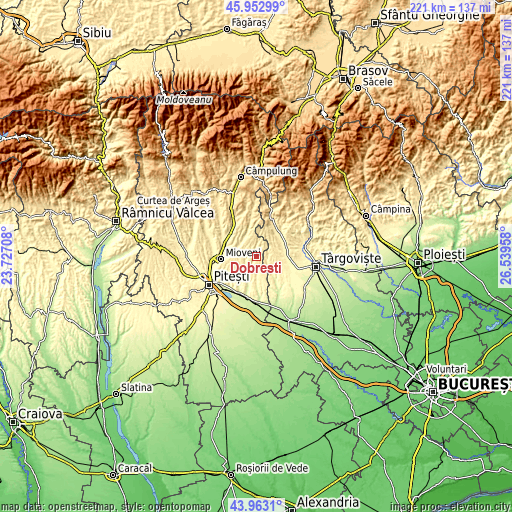
| \ | Map #1 | Topo.Map |
| Scale [m] | 321..513 m | × |
| Scale [ft] | 1053..1683 ft | × |
| Average | 435 m = 1427 ft | × |
| Width | 6.91 km = 4.3 mi | 221.3 km = 137.5 mi |
| Height | 6.91 km = 4.3 mi | 221.2 km = 137.4 mi |
| ↑Max Latitude | 44.997754° | 45.95299° |
| Latitude at center | 44.96667° | 44.96667° |
| ↓Min Latitude | 44.935569° | 43.9631° |
| ← Min Longitude | 25.089385° | 23.72708° |
| Longitude center | 25.13333° | 25.13333° |
| →Max Longitude | 25.177275° | 26.53958° |
Nearby cities:
Cities around Dobreşti sort by population:
• Tătărani elevation 408 m
11.1 km,  70°
70°
• Bogaţi 287 m
11.1 km,  180°
180°
• Priboieni 279 m
10.1 km,  203°
203°
• Davideşti 452 m
9.6 km,  305°
305°
• Vulturești 420 m
11.7 km,  340°
340°
• Beleţi 294 m
8.4 km,  207°
207°
• Căprioru 341 m
11.8 km,  81°
81°
• Conțești 354 m
9.9 km,  281°
281°
• Boţeşti 465 m
5.6 km,  0°
0°
• Scheiu de Jos 334 m
6.3 km,  124°
124°
• Suseni 328 m
7.4 km,  173°
173°
• Scheiu de Sus 344 m
4.9 km,  104°
104°
Multilingual:
 En español:
Dobreşti elevación 403 m.
 En France:
Dobreşti élévation 403 m.
 Auf Deutsch:
Dobreşti höhe über dem Meeresspiegel ist 403 m.

Sources and notes:
- [note 1] Map square and city borders are not equal. Map elevation data is calculated only from area inside that square.
- [src 1] Elevation data from geonames database provided with same terms of usage.
- [src 2] The elevation map of Dobreşti is generated using elevation data from NASA's 3 arcsec (90m) resolution SRTM data.
- [src 3] Base (background) map © OpenStreetMap contributors tiles are generated by Geofabrik and OpenTopoMap.
Copyright & License:
This Dobreşti Elevation Map is licensed under CC BY-SA. You may reuse any part from this page, if you give a proper credit by linking to this URL:
 More info on terms of use page.