Titeşti elevation
Titeşti (Arges, Comuna Țițești), Romania elevation is 419 meters and Titeşti elevation in feet is 1375 ft above sea level [src 1]. Titeşti is a seat of a second-order administrative division (feature code) with elevation that is 167 meters (548 ft) bigger than average city elevation in Romania.
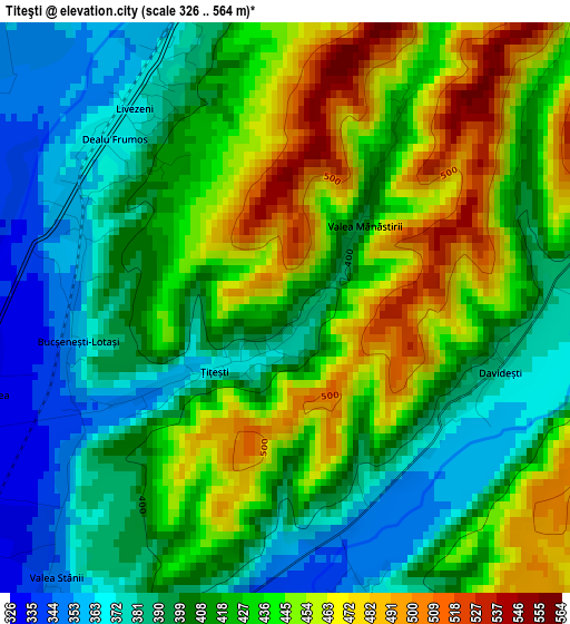
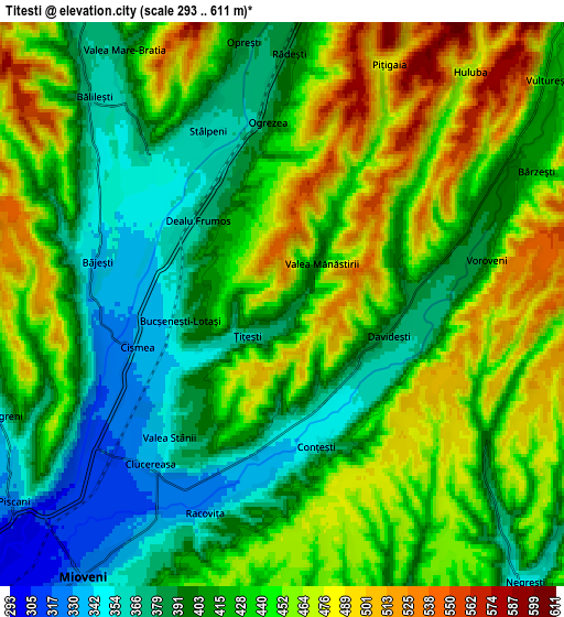
Below is the Elevation map of Titeşti, which displays elevation range with different colors. Scale of the first map is from 326 to 564 m (1070 to 1850 ft) with average elevation of 419.5 meters (=1376 ft) [note 1]
These maps also provides idea of topography and contour of this city, they are displayed at different zoom levels. More info about maps, scale and edge coordinates you can find below images.
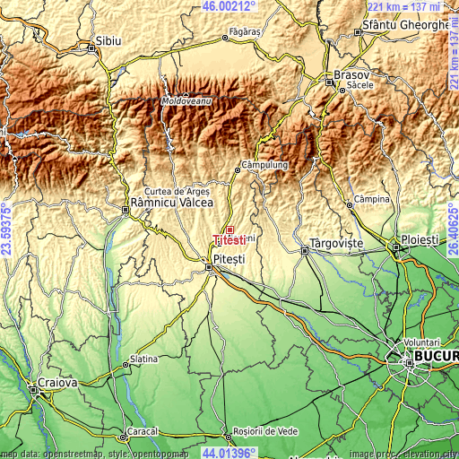
| \ | Map #1 | Map #2 | Topo.Map |
| Scale [m] | 326..564 m | 293..611 m | × |
| Scale [ft] | 1070..1850 ft | 961..2005 ft | × |
| Average | 419.5 m = 1376 ft | 427.5 m = 1403 ft | × |
| Width | 6.91 km = 4.3 mi | 13.82 km = 8.6 mi | 221.1 km = 137.4 mi |
| Height | 6.91 km = 4.3 mi | 13.82 km = 8.6 mi | 221.1 km = 137.4 mi |
| ↑Max Latitude | 45.047727° | 45.078766° | 46.00212° |
| Latitude at center | 45.01667° | 45.01667° | 45.01667° |
| ↓Min Latitude | 44.985597° | 44.954506° | 44.01396° |
| ← Min Longitude | 24.956055° | 24.912109° | 23.59375° |
| Longitude center | 25° | 25° | 25° |
| →Max Longitude | 25.043945° | 25.087891° | 26.40625° |
Nearby cities:
Cities around Titeşti sort by population:
• Mioveni elevation 326 m
7.9 km,  215°
215°
• Stâlpeni 356 m
4.5 km,  324°
324°
• Bălileşti 476 m
7.6 km, 316°
• Dărmăneşti 344 m
7.9 km,  270°
270°
• Davideşti 452 m
2.6 km,  90°
90°
• Racovița 327 m
5.4 km,  200°
200°
• Conțești 354 m
3.6 km,  167°
167°
• Livezeni 370 m
3 km, 322°
• Rădești 388 m
6.1 km,  1°
1°
• Băjești 344 m
4.8 km,  282°
282°
• Valea Popii 444 m
8.6 km,  11°
11°
• Bucșenești-Lotași 360 m
2.5 km,  260°
260°
Multilingual:
 En español:
Titeşti elevación 419 m.
 En France:
Titeşti élévation 419 m.


Sources and notes:
- [note 1] Map square and city borders are not equal. Map elevation data is calculated only from area inside that square.
- [src 1] Elevation data from geonames database provided with same terms of usage.
- [src 2] The elevation map of Titeşti is generated using elevation data from NASA's 3 arcsec (90m) resolution SRTM data.
- [src 3] Base (background) map © OpenStreetMap contributors tiles are generated by Geofabrik and OpenTopoMap.
Copyright & License:
This Titeşti Elevation Map is licensed under CC BY-SA. You may reuse any part from this page, if you give a proper credit by linking to this URL:
 More info on terms of use page.