Mioveni elevation
Mioveni (Arges, Oraș Mioveni), Romania elevation is 326 meters and Mioveni elevation in feet is 1070 ft above sea level [src 1]. Mioveni is a seat of a second-order administrative division (feature code) with elevation that is 74 meters (243 ft) bigger than average city elevation in Romania.
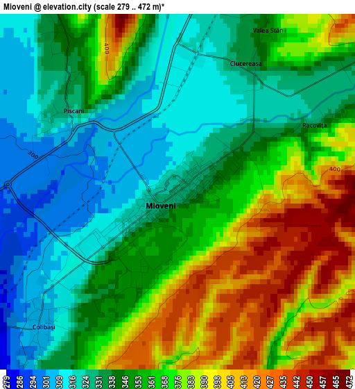
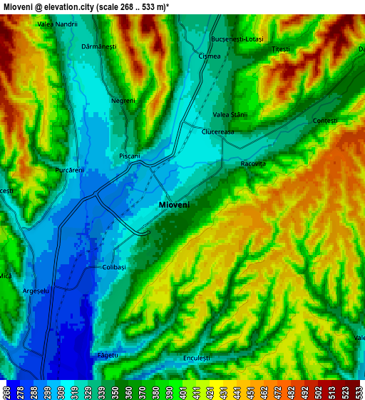
Below is the Elevation map of Mioveni, which displays elevation range with different colors. Scale of the first map is from 279 to 472 m (915 to 1549 ft) with average elevation of 355.1 meters (=1165 ft) [note 1]
These maps also provides idea of topography and contour of this city, they are displayed at different zoom levels. More info about maps, scale and edge coordinates you can find below images.
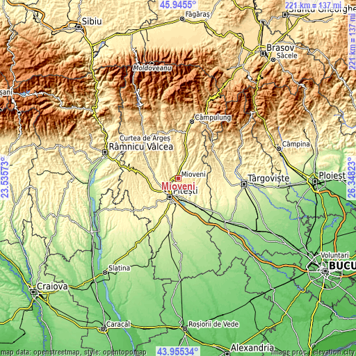
| \ | Map #1 | Map #2 | Topo.Map |
| Scale [m] | 279..472 m | 268..533 m | × |
| Scale [ft] | 915..1549 ft | 879..1749 ft | × |
| Average | 355.1 m = 1165 ft | 373.7 m = 1226 ft | × |
| Width | 6.92 km = 4.3 mi | 13.83 km = 8.6 mi | 221.3 km = 137.5 mi |
| Height | 6.92 km = 4.3 mi | 13.83 km = 8.6 mi | 221.3 km = 137.5 mi |
| ↑Max Latitude | 44.990138° | 45.021209° | 45.9455° |
| Latitude at center | 44.95905° | 44.95905° | 44.95905° |
| ↓Min Latitude | 44.927945° | 44.896824° | 43.95534° |
| ← Min Longitude | 24.898035° | 24.854089° | 23.53573° |
| Longitude center | 24.94198° | 24.94198° | 24.94198° |
| →Max Longitude | 24.985925° | 25.029871° | 26.34823° |
Nearby cities:
Cities around Mioveni sort by population:
• Titeşti elevation 419 m
7.9 km,  35°
35°
• Miceşti 353 m
6 km,  260°
260°
• Budeasa Mică 455 m
7.3 km, 262°
• Dărmăneşti 344 m
7.2 km,  332°
332°
• Colibași 306 m
3.7 km,  224°
224°
• Racovița 327 m
3 km,  63°
63°
• Argeșelu 295 m
6.6 km,  237°
237°
• Purcăreni 316 m
4.4 km,  283°
283°
• Conțești 354 m
6.1 km, 61°
• Băjești 344 m
7.5 km,  358°
358°
• Făgetu 291 m
6.3 km,  202°
202°
• Bucșenești-Lotași 360 m
6.4 km,  19°
19°
Multilingual:
 En español:
Mioveni elevación 326 m.
 En France:
Mioveni élévation 326 m.


Sources and notes:
- [note 1] Map square and city borders are not equal. Map elevation data is calculated only from area inside that square.
- [src 1] Elevation data from geonames database provided with same terms of usage.
- [src 2] The elevation map of Mioveni is generated using elevation data from NASA's 3 arcsec (90m) resolution SRTM data.
- [src 3] Base (background) map © OpenStreetMap contributors tiles are generated by Geofabrik and OpenTopoMap.
Copyright & License:
This Mioveni Elevation Map is licensed under CC BY-SA. You may reuse any part from this page, if you give a proper credit by linking to this URL:
 More info on terms of use page.