Brebeni elevation
Brebeni (Olt, Comuna Brebeni), Romania elevation is 129 meters and Brebeni elevation in feet is 423 ft above sea level [src 1]. Brebeni is a seat of a second-order administrative division (feature code) with elevation that is 123 meters (404 ft) smaller than average city elevation in Romania.
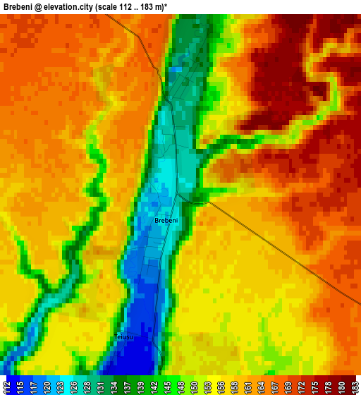
Below is the Elevation map of Brebeni, which displays elevation range with different colors. Scale of the first map is from 112 to 183 m (367 to 600 ft) with average elevation of 155.8 meters (=511 ft) [note 1]
These maps also provides idea of topography and contour of this city, they are displayed at different zoom levels. More info about maps, scale and edge coordinates you can find below images.
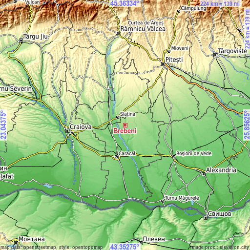
| \ | Map #1 | Topo.Map |
| Scale [m] | 112..183 m | × |
| Scale [ft] | 367..600 ft | × |
| Average | 155.8 m = 511 ft | × |
| Width | 6.99 km = 4.3 mi | 223.6 km = 138.9 mi |
| Height | 6.99 km = 4.3 mi | 223.5 km = 138.9 mi |
| ↑Max Latitude | 44.398077° | 45.36334° |
| Latitude at center | 44.36667° | 44.36667° |
| ↓Min Latitude | 44.335246° | 43.35275° |
| ← Min Longitude | 24.406055° | 23.04375° |
| Longitude center | 24.45° | 24.45° |
| →Max Longitude | 24.493945° | 25.85625° |
Nearby cities:
Cities around Brebeni sort by population:
• Slatina elevation 165 m
9.9 km,  318°
318°
• Perieţi 181 m
8.8 km,  64°
64°
• Valea Mare 198 m
11.2 km,  353°
353°
• Izvoarele 139 m
12.3 km,  154°
154°
• Schitu 136 m
9.5 km,  101°
101°
• Coteana 143 m
7.5 km,  169°
169°
• Slătioara 107 m
11.2 km,  289°
289°
• Bălteni 195 m
11.2 km,  35°
35°
• Ipotești 114 m
6 km,  220°
220°
• Greci 129 m
9.6 km,  114°
114°
• Vâlcele 124 m
12 km,  141°
141°
• Catanele 151 m
9 km,  79°
79°
Multilingual:
 En español:
Brebeni elevación 129 m.
 En France:
Brebeni élévation 129 m.


Sources and notes:
- [note 1] Map square and city borders are not equal. Map elevation data is calculated only from area inside that square.
- [src 1] Elevation data from geonames database provided with same terms of usage.
- [src 2] The elevation map of Brebeni is generated using elevation data from NASA's 3 arcsec (90m) resolution SRTM data.
- [src 3] Base (background) map © OpenStreetMap contributors tiles are generated by Geofabrik and OpenTopoMap.
Copyright & License:
This Brebeni Elevation Map is licensed under CC BY-SA. You may reuse any part from this page, if you give a proper credit by linking to this URL:
 More info on terms of use page.