Vâlcele elevation
Vâlcele (Olt, Comuna Vâlcele), Romania elevation is 124 meters and Vâlcele elevation in feet is 407 ft above sea level [src 1]. Vâlcele is a populated place (feature code) with elevation that is 128 meters (420 ft) smaller than average city elevation in Romania.
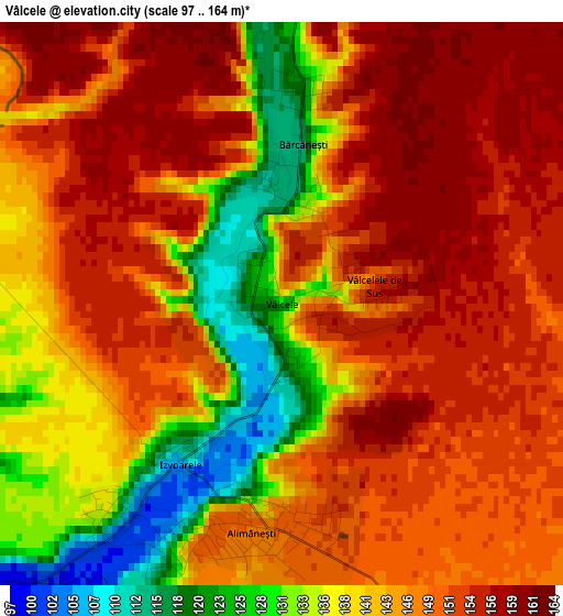
Below is the Elevation map of Vâlcele, which displays elevation range with different colors. Scale of the first map is from 97 to 164 m (318 to 538 ft) with average elevation of 144.9 meters (=475 ft) [note 1]
These maps also provides idea of topography and contour of this city, they are displayed at different zoom levels. More info about maps, scale and edge coordinates you can find below images.
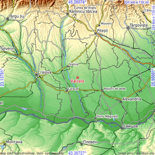
| \ | Map #1 | Topo.Map |
| Scale [m] | 97..164 m | × |
| Scale [ft] | 318..538 ft | × |
| Average | 144.9 m = 475 ft | × |
| Width | 7 km = 4.3 mi | 223.9 km = 139.1 mi |
| Height | 7 km = 4.3 mi | 223.9 km = 139.1 mi |
| ↑Max Latitude | 44.314082° | 45.28074° |
| Latitude at center | 44.28263° | 44.28263° |
| ↓Min Latitude | 44.251161° | 43.26727° |
| ← Min Longitude | 24.499815° | 23.13751° |
| Longitude center | 24.54376° | 24.54376° |
| →Max Longitude | 24.587705° | 25.95001° |
Nearby cities:
Cities around Vâlcele sort by population:
• Mărunţei elevation 82 m
11.1 km,  213°
213°
• Izvoarele 139 m
2.8 km,  230°
230°
• Comani 77 m
11.8 km,  200°
200°
• Schitu 136 m
7.7 km,  13°
13°
• Coteana 143 m
6.4 km,  287°
287°
• Brebeni 129 m
12 km,  321°
321°
• Alimănești 147 m
2.9 km,  187°
187°
• Bălănești 99 m
6.1 km, 233°
• Ipotești 114 m
12.3 km, 292°
• Greci 129 m
5.4 km, 13°
• Vâlcelele de Sus 152 m
1.2 km,  79°
79°
• Catanele 151 m
11.1 km, 7°
Multilingual:
 En español:
Vâlcele elevación 124 m.
 En France:
Vâlcele élévation 124 m.


Sources and notes:
- [note 1] Map square and city borders are not equal. Map elevation data is calculated only from area inside that square.
- [src 1] Elevation data from geonames database provided with same terms of usage.
- [src 2] The elevation map of Vâlcele is generated using elevation data from NASA's 3 arcsec (90m) resolution SRTM data.
- [src 3] Base (background) map © OpenStreetMap contributors tiles are generated by Geofabrik and OpenTopoMap.
Copyright & License:
This Vâlcele Elevation Map is licensed under CC BY-SA. You may reuse any part from this page, if you give a proper credit by linking to this URL:
 More info on terms of use page.