Bălteni elevation
Bălteni (Olt, Comuna Bălteni), Romania elevation is 195 meters and Bălteni elevation in feet is 640 ft above sea level [src 1]. Bălteni is a seat of a second-order administrative division (feature code) with elevation that is 57 meters (187 ft) smaller than average city elevation in Romania.
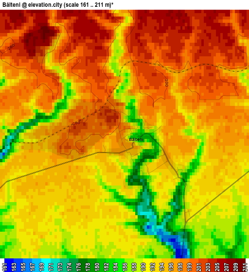
Below is the Elevation map of Bălteni, which displays elevation range with different colors. Scale of the first map is from 161 to 211 m (528 to 692 ft) with average elevation of 194.4 meters (=638 ft) [note 1]
These maps also provides idea of topography and contour of this city, they are displayed at different zoom levels. More info about maps, scale and edge coordinates you can find below images.
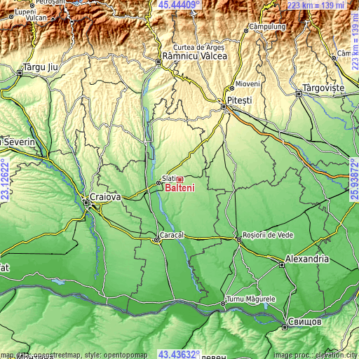
| \ | Map #1 | Topo.Map |
| Scale [m] | 161..211 m | × |
| Scale [ft] | 528..692 ft | × |
| Average | 194.4 m = 638 ft | × |
| Width | 6.98 km = 4.3 mi | 223.2 km = 138.7 mi |
| Height | 6.98 km = 4.3 mi | 223.2 km = 138.7 mi |
| ↑Max Latitude | 44.480193° | 45.44409° |
| Latitude at center | 44.44883° | 44.44883° |
| ↓Min Latitude | 44.41745° | 43.43632° |
| ← Min Longitude | 24.488525° | 23.12622° |
| Longitude center | 24.53247° | 24.53247° |
| →Max Longitude | 24.576415° | 25.93872° |
Nearby cities:
Cities around Bălteni sort by population:
• Potcoava elevation 185 m
10.1 km,  67°
67°
• Perieţi 181 m
5.6 km,  165°
165°
• Valea Mare 198 m
8.1 km,  284°
284°
• Brebeni 129 m
11.2 km,  215°
215°
• Priseaca 218 m
10 km,  319°
319°
• Bacea 162 m
10.1 km,  123°
123°
• Valea Merilor 162 m
10.1 km,  75°
75°
• Bircii 184 m
9.4 km,  36°
36°
• Potcoava Fălcoeni 207 m
8.4 km,  52°
52°
• Mărgineni Slobozia 190 m
9.4 km,  11°
11°
• Catanele 151 m
7.8 km,  162°
162°
• Sinești 156 m
10.8 km, 78°
Multilingual:
 En español:
Bălteni elevación 195 m.
 En France:
Bălteni élévation 195 m.


Sources and notes:
- [note 1] Map square and city borders are not equal. Map elevation data is calculated only from area inside that square.
- [src 1] Elevation data from geonames database provided with same terms of usage.
- [src 2] The elevation map of Bălteni is generated using elevation data from NASA's 3 arcsec (90m) resolution SRTM data.
- [src 3] Base (background) map © OpenStreetMap contributors tiles are generated by Geofabrik and OpenTopoMap.
Copyright & License:
This Bălteni Elevation Map is licensed under CC BY-SA. You may reuse any part from this page, if you give a proper credit by linking to this URL:
 More info on terms of use page.