Potcoava elevation
Potcoava (Olt, Oraş Potcoava), Romania elevation is 185 meters and Potcoava elevation in feet is 607 ft above sea level [src 1]. Potcoava is a seat of a second-order administrative division (feature code) with elevation that is 67 meters (220 ft) smaller than average city elevation in Romania.
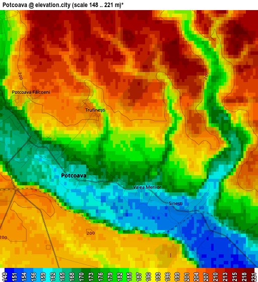
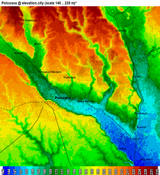
Below is the Elevation map of Potcoava, which displays elevation range with different colors. Scale of the first map is from 148 to 221 m (486 to 725 ft) with average elevation of 189.8 meters (=623 ft) [note 1]
These maps also provides idea of topography and contour of this city, they are displayed at different zoom levels. More info about maps, scale and edge coordinates you can find below images.
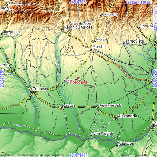
| \ | Map #1 | Map #2 | Topo.Map |
| Scale [m] | 148..221 m | 140..235 m | × |
| Scale [ft] | 486..725 ft | 459..771 ft | × |
| Average | 189.8 m = 623 ft | 189.5 m = 622 ft | × |
| Width | 6.97 km = 4.3 mi | 13.94 km = 8.7 mi | 223.1 km = 138.6 mi |
| Height | 6.97 km = 4.3 mi | 13.94 km = 8.7 mi | 223.1 km = 138.6 mi |
| ↑Max Latitude | 44.514675° | 44.546002° | 45.478° |
| Latitude at center | 44.48333° | 44.48333° | 44.48333° |
| ↓Min Latitude | 44.451969° | 44.42059° | 43.47141° |
| ← Min Longitude | 24.606055° | 24.562109° | 23.24375° |
| Longitude center | 24.65° | 24.65° | 24.65° |
| →Max Longitude | 24.693945° | 24.737891° | 26.05625° |
Nearby cities:
Cities around Potcoava sort by population:
• Corbu elevation 161 m
5.3 km,  90°
90°
• Icoana 144 m
9.1 km,  144°
144°
• Vitănești 181 m
6.1 km,  36°
36°
• Bălteni 195 m
10.1 km,  247°
247°
• Bacea 162 m
9.5 km,  185°
185°
• Negreni 209 m
10.4 km,  335°
335°
• Valea Merilor 162 m
1.4 km,  159°
159°
• Bircii 184 m
5.2 km,  315°
315°
• Potcoava Fălcoeni 207 m
2.9 km,  295°
295°
• Mărgineni Slobozia 190 m
9.1 km,  305°
305°
• Sinești 156 m
2.1 km, 143°
• Sârbii-Măgura 194 m
9.1 km, 35°
Multilingual:
 En español:
Potcoava elevación 185 m.
 En France:
Potcoava élévation 185 m.
 Auf Deutsch:
Potcoava höhe über dem Meeresspiegel ist 185 m.

Sources and notes:
- [note 1] Map square and city borders are not equal. Map elevation data is calculated only from area inside that square.
- [src 1] Elevation data from geonames database provided with same terms of usage.
- [src 2] The elevation map of Potcoava is generated using elevation data from NASA's 3 arcsec (90m) resolution SRTM data.
- [src 3] Base (background) map © OpenStreetMap contributors tiles are generated by Geofabrik and OpenTopoMap.
Copyright & License:
This Potcoava Elevation Map is licensed under CC BY-SA. You may reuse any part from this page, if you give a proper credit by linking to this URL:
 More info on terms of use page.