Broşteni elevation
Broşteni (Suceava, Oraş Broşteni), Romania elevation is 699 meters and Broşteni elevation in feet is 2293 ft above sea level [src 1]. Broşteni is a seat of a second-order administrative division (feature code) with elevation that is 447 meters (1467 ft) bigger than average city elevation in Romania.
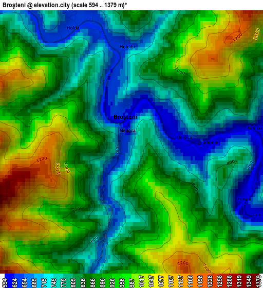
Below is the Elevation map of Broşteni, which displays elevation range with different colors. Scale of the first map is from 594 to 1379 m (1949 to 4524 ft) with average elevation of 873.4 meters (=2865 ft) [note 1]
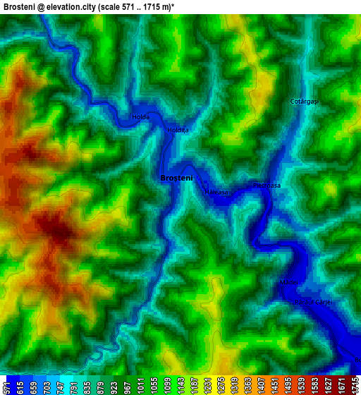
These maps also provides idea of topography and contour of this city, they are displayed at different zoom levels. More info about maps, scale and edge coordinates you can find below images.
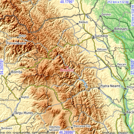
| \ | Map #1 | Map #2 | Topo.Map |
| Scale [m] | 594..1379 m | 571..1715 m | × |
| Scale [ft] | 1949..4524 ft | 1873..5627 ft | × |
| Average | 873.4 m = 2865 ft | 980.6 m = 3217 ft | × |
| Width | 6.64 km = 4.1 mi | 13.27 km = 8.2 mi | 212.3 km = 131.9 mi |
| Height | 6.64 km = 4.1 mi | 13.27 km = 8.2 mi | 212.3 km = 131.9 mi |
| ↑Max Latitude | 47.263161° | 47.292975° | 48.1796° |
| Latitude at center | 47.23333° | 47.23333° | 47.23333° |
| ↓Min Latitude | 47.203482° | 47.173617° | 46.26986° |
| ← Min Longitude | 25.656055° | 25.612109° | 24.29375° |
| Longitude center | 25.7° | 25.7° | 25.7° |
| →Max Longitude | 25.743945° | 25.787891° | 27.10625° |
Nearby cities:
Cities around Broşteni sort by population:
• Borca elevation 856 m
7.5 km,  137°
137°
• Poiana Teiului 664 m
25 km,  126°
126°
• Fărcaşa 770 m
12.5 km, 126°
• Ostra 765 m
19.2 km,  15°
15°
• Bilbor 958 m
24.7 km,  214°
214°
• Grinţieş 723 m
24 km,  148°
148°
• Panaci 914 m
24.2 km,  278°
278°
• Crucea 748 m
14.4 km,  334°
334°
• Sabasa 644 m
9.6 km,  111°
111°
• Boboiești 667 m
25.6 km,  84°
84°
• Dorna-Arini 807 m
25 km,  297°
297°
• Negrileasa 645 m
22.9 km, 22°
Multilingual:
 En español:
Broşteni elevación 699 m.
 En France:
Broşteni élévation 699 m.
 Auf Deutsch:
Broşteni höhe über dem Meeresspiegel ist 699 m.

Sources and notes:
- [note 1] Map square and city borders are not equal. Map elevation data is calculated only from area inside that square.
- [src 1] Elevation data from geonames database provided with same terms of usage.
- [src 2] The elevation map of Broşteni is generated using elevation data from NASA's 3 arcsec (90m) resolution SRTM data.
- [src 3] Base (background) map © OpenStreetMap contributors tiles are generated by Geofabrik and OpenTopoMap.
Copyright & License:
This Broşteni Elevation Map is licensed under CC BY-SA. You may reuse any part from this page, if you give a proper credit by linking to this URL:
 More info on terms of use page.